Gabas (river)
| Gabas | |
|---|---|
 | |
| Location | |
| Country | France |
| Physical characteristics | |
| Source | |
| - location | Plateau of Ger |
| Mouth | |
- location | Adour |
- coordinates | 43°45′41″N 0°42′9″W / 43.76139°N 0.70250°W / 43.76139; -0.70250 (Adour-Louts)Coordinates: 43°45′41″N 0°42′9″W / 43.76139°N 0.70250°W / 43.76139; -0.70250 (Adour-Louts) |
| Length | 117 km (73 mi) |
| Basin features | |
| Progression | Adour→ Atlantic Ocean |
This article may be expanded with text translated from the corresponding article in French. (September 2014) Click [show] for important translation instructions.
|
The Gabas, is a left tributary of the Adour, in the Landes, in the Southwest of France.
Contents
1 Name
2 Geography
3 Main tributaries
4 References
Name
The name Gabas is derived from the French 'gave'[1] (Gascon: 'gabe'), which in the Pyrenees generically describes a small or large watercourse. The river was known as the fluvius gavasensis in 982.[2]
A tributary of the Léez is named the Gabassot, an hypocoristic of Gabas.
Geography
The Gabas rises in the plateau of Ger in the north of Lourdes, as the union of the Gabastou and the Honrède. It flows north-west like the neighboring rivers: the Luy, the Uzan and the Ousse.
The Gabas crosses the Tursan, in the Landes. It flows into the Adour in Toulouzette, downstream from Saint-Sever.
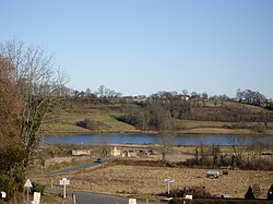
A dam of 20 million cubic metres (16,000 acre⋅ft) was built in its upper course to regulate the lowest water level.
Main tributaries
- (R) the Bayle from Lourenties
- (R) the Bas, from Geaune
- (R) the Lescoû, from Saint-Loubouer
- (L) the Petit Bas, from Pimbo
- (R) the Lescoû, from Saint-Loubouer
- (L) the Laudon, from Hagetmau
References
- http://www.geoportail.fr
- The Gabas at the Sandre database
^ fr:Gave
^ cartulary of Saint-Sever.
This article related to a river in France is a stub. You can help Wikipedia by expanding it. |


