Guandu metro station
Guandu R25 關渡 | |
|---|---|
 Guandu station | |
| Location | No. 51, Lane 296, Dadu Road, Sec. 3 Beitou, Taipei Taiwan |
| Operated by |
|
| Line(s) |
|
| Connections | Bus stop |
| Construction | |
| Structure type | At-Grade |
| History | |
| Opened | 28 March 1997 |
| Traffic | |
| Passengers | 23,409 daily (2016)[1] (Ranked 61st of 109) |
| Guandu metro station | |||||||||||||||||||||
| Traditional Chinese | 關渡站 | ||||||||||||||||||||
|---|---|---|---|---|---|---|---|---|---|---|---|---|---|---|---|---|---|---|---|---|---|
| Simplified Chinese | 关渡站 | ||||||||||||||||||||
| |||||||||||||||||||||
The Taipei Metro Guandu station (formerly Kuantu Station until 2003) is located in Beitou District, Taipei, Taiwan. It is a station on the Tamsui Line. In the past, the station belonged to the now-defunct TRA Tamsui Line.
Contents
1 Station overview
2 History
3 Station layout
4 Around the station
5 References
Station overview
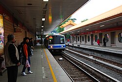
A train arriving at Guandu station.

Guandu station concourse.
The at-grade, station structure with two side platforms and two exits. The washrooms are inside the entrance area.[2] The station is situated southwest of Guandu Elementary School, between Zhongyang North Road, Dadu Road and Ligong Street.
History
The station was originally opened on 25 December 1901 with the opening of the Tamsui Railroad Line (as "Jiangtou Parking Station"). After the war it was renamed to Guandu. On 15 July 1988, this service was discontinued and station was closed, and was re-opened on 28 March 1997.
The five millionth EasyCard was sold at Guandu station on 7 February 2005.[3]
Station layout
2F | Connecting Level | Skyway for Platform Connection |
Street Level | ||
Side platform, doors will open on the right | ||
| Platform 1 | ← | |
| Platform 2 | → | |
Side platform, doors will open on the right | ||
| Concourse (to Platform 2) | ||
| Entrance/Exit, lobby, information desk, automatic ticket dispensing machines, one-way faregates Restrooms, shops | ||
Around the station
- Guandu Nature Park
- Tittot Glass Art Museum
.mw-parser-output .adjacent-stationsmax-width:50em;margin:0.5em auto;font-size:95%;clear:both.mw-parser-output .adjacent-stations .isAfont-size:smaller;font-style:italic.mw-parser-output .adjacent-stations .smAfont-size:smaller.mw-parser-output .adjacent-stations .hcAwidth:30%;vertical-align:middle.mw-parser-output .adjacent-stations .hmAvertical-align:middle.mw-parser-output .adjacent-stations .bcAtext-align:center;vertical-align:middle.mw-parser-output .adjacent-stations .bbAtext-align:center;width:8px;min-width:8px
| Preceding station | Following station | |||
|---|---|---|---|---|
Zhuwei towards Tamsui | Tamsui–Xinyi line | Zhongyi towards Xiangshan or Daan | ||
References
| Wikimedia Commons has media related to Guandu Station. |
^ "Passenger Volume at Taipei Rapid Transit Stations" (PDF). Taipei City Department of Transportation. 2017-03-13. Retrieved 2017-03-13..mw-parser-output cite.citationfont-style:inherit.mw-parser-output .citation qquotes:"""""""'""'".mw-parser-output .citation .cs1-lock-free abackground:url("//upload.wikimedia.org/wikipedia/commons/thumb/6/65/Lock-green.svg/9px-Lock-green.svg.png")no-repeat;background-position:right .1em center.mw-parser-output .citation .cs1-lock-limited a,.mw-parser-output .citation .cs1-lock-registration abackground:url("//upload.wikimedia.org/wikipedia/commons/thumb/d/d6/Lock-gray-alt-2.svg/9px-Lock-gray-alt-2.svg.png")no-repeat;background-position:right .1em center.mw-parser-output .citation .cs1-lock-subscription abackground:url("//upload.wikimedia.org/wikipedia/commons/thumb/a/aa/Lock-red-alt-2.svg/9px-Lock-red-alt-2.svg.png")no-repeat;background-position:right .1em center.mw-parser-output .cs1-subscription,.mw-parser-output .cs1-registrationcolor:#555.mw-parser-output .cs1-subscription span,.mw-parser-output .cs1-registration spanborder-bottom:1px dotted;cursor:help.mw-parser-output .cs1-ws-icon abackground:url("//upload.wikimedia.org/wikipedia/commons/thumb/4/4c/Wikisource-logo.svg/12px-Wikisource-logo.svg.png")no-repeat;background-position:right .1em center.mw-parser-output code.cs1-codecolor:inherit;background:inherit;border:inherit;padding:inherit.mw-parser-output .cs1-hidden-errordisplay:none;font-size:100%.mw-parser-output .cs1-visible-errorfont-size:100%.mw-parser-output .cs1-maintdisplay:none;color:#33aa33;margin-left:0.3em.mw-parser-output .cs1-subscription,.mw-parser-output .cs1-registration,.mw-parser-output .cs1-formatfont-size:95%.mw-parser-output .cs1-kern-left,.mw-parser-output .cs1-kern-wl-leftpadding-left:0.2em.mw-parser-output .cs1-kern-right,.mw-parser-output .cs1-kern-wl-rightpadding-right:0.2em
^ "Route Map: Guandu". Taipei Rapid Transit Corporation. Retrieved 2010-06-20.
^ "Over 5 million Easy Cards sold". The China Post. 2005-02-21. Retrieved 2010-06-20.
Coordinates: 25°07′33″N 121°28′02″E / 25.125805°N 121.467338°E / 25.125805; 121.467338
Taipei Metro stations | |||||
|---|---|---|---|---|---|
(Boldface denotes an MRT interchange station; "gray" denotes unused stations.) | |||||
| |||||
| |||||
| |||||
| |||||
| |||||
Y Circular Line (Circular / North-South)[u/c; planned] |
| ||||
| Stations |
| ||||||
|---|---|---|---|---|---|---|---|
| Rolling stock |
| ||||||
| |||||||
This Taiwanese rapid transit article is a stub. You can help Wikipedia by expanding it. |


