Maumee River
| Maumee River | |
|---|---|
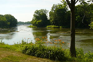 The Maumee River at Grand Rapids, Ohio | |
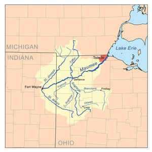 Map of the Maumee River watershed | |
| Location | |
| Country | United States |
| States | Indiana, Ohio |
| Cities and towns | Fort Wayne, Indiana; New Haven, Indiana; Antwerp, Ohio; Cecil, Ohio; Defiance, Ohio; Florida, Ohio; Napoleon, Ohio; Grand Rapids, Ohio; Waterville, Ohio; Maumee, Ohio; Perrysburg, Ohio; Rossford, Ohio; Toledo, Ohio; Oregon, Ohio |
| Physical characteristics | |
| Source | |
| - location | Fort Wayne by the confluence of the St. Joseph and St. Marys |
| - coordinates | 41°04′58″N 85°07′56″W / 41.0827778°N 85.1322222°W / 41.0827778; -85.1322222 (Maumee River origin) |
| - elevation | 750 ft (230 m) |
| Mouth | |
- location | Lake Erie at Toledo |
- coordinates | 41°41′58″N 83°27′36″W / 41.6994444°N 83.46°W / 41.6994444; -83.46 (Maumee River mouth)Coordinates: 41°41′58″N 83°27′36″W / 41.6994444°N 83.46°W / 41.6994444; -83.46 (Maumee River mouth) |
- elevation | 571 ft (174 m) |
| Length | 137 miles (220 km) |
| Basin size | 6,354 sq mi (16,460 km2) |
| Discharge | |
| - average | 5,297 cu ft/s (150.0 m3/s) |
| Basin features | |
| Progression | Northeast |
The Maumee River (pronounced /mɔːˈmiː/)[1] (Shawnee: Hotaawathiipi;[2]Miami-Illinois: Taawaawa siipiiwi)[3] is a river running from northeastern Indiana into northwestern Ohio and Lake Erie in the United States. It is formed at the confluence of the St. Joseph and St. Marys rivers, where Fort Wayne, Indiana, has developed, and meanders northeastwardly for 137 miles (220 km)[4] through an agricultural region of glacial moraines before flowing into the Maumee Bay of Lake Erie. The city of Toledo is located at the mouth of the Maumee. The Maumee was designated an Ohio State Scenic River on July 18, 1974. The Maumee watershed is Ohio’s breadbasket; it is two-thirds farmland, mostly corn and soybeans. It is the largest watershed of any of the rivers feeding the Great Lakes,[5] and supplies five percent of Lake Erie’s water.[6]
Contents
1 History
2 Natural history
3 Transportation
4 Watershed
5 Islands
6 Walleye run
7 Cities and towns along the river
8 See also
9 References
10 Further reading
11 External links
History
Historically the river was also known as the "Miami" in United States treaties with Native Americans. As early as 1671, French colonists called the river Miami du Lac, or Miami of the Lake (in contrast to the "Miami of the Ohio" or the Great Miami River, called in Miami-Illinois Ahsenisiipi). Maumee is an anglicized spelling of the Ottawa or Odawa name for the Miami tribe, Maamii. The Odawa had a village at the mouth of the Maumee River and occupied other territory in northwestern Ohio.[7]
The Battle of Fallen Timbers, the final battle of the Northwest Indian War, was fought 3⁄4 mile (1.2 km) north of the banks of the Maumee River. After this decisive victory for General Anthony Wayne, Native Americans ceded a twelve mile square tract around Perrysburg and Maumee to the United States by the Treaty of Greenville in 1795.[8] Lands north of the river and downstream of Defiance were ceded in the 1807 Treaty of Detroit,[9] and the rest of the Maumee River valley was ceded in the 1817 Treaty of Fort Meigs.[10]
Prior to the development of canals, portages between the rivers were important trade routes. U.S. forces built forts such as Fort Loramie, Fort Recovery, and Fort Defiance. In honor of General Wayne's victory on the banks of the Maumee, the primary bridge crossing the river near downtown Toledo is named the Anthony Wayne Suspension Bridge.
A dispute over control of part of the Maumee River region led to the so-called Toledo War between Ohio and the Michigan Territory.
Agricultural practices along the Maumee River have contributed in the 21st century to high phosphate levels in Lake Erie. This triggered algae blooms in the lake,[6] rendering drinking water from the city of Toledo unsafe for consumption for nearly a week in August 2014.[11]
Natural history
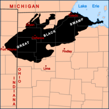
The general extent of the Great Black Swamp prior to the 19th century
The Maumee River watershed was once part of the Great Black Swamp, a remnant of Glacial Lake Maumee, the proglacial ancestor of Lake Erie. The 1,500-square-mile (3,900 km2) swamp was a vast network of forests, wetlands, and grasslands, a rich habitat for numerous species of birds, animals, fish and flora. During the 19th century, European-American settlers struggled to drain the swamp and to convert the land to farmland; they dramatically altered the habitat, reducing areas where species could flourish.
Transportation
The mouth of the river at Toledo and Lake Erie is wide and supports considerable commercial traffic, including oil, grain, and coal. About 12 miles (19 km) upstream, in the town of Perrysburg, Ohio, the river becomes much shallower and today supports only recreational navigation above that point. The Miami and Erie Canal was built parallel to and north of the Maumee between Toledo and Defiance, Ohio, to enable extended transportation of shipped goods. The canal entered the river at a "slackwater" created by Independence Dam. It exited the river at Defiance and was built to the south, ending at Cincinnati, Ohio. While abandoned for commercial use, portions of the canal's towpath are maintained for recreational use in both Lucas and Henry counties. A restored section of canal, including a canal lock, is operated at Providence Metropark, where visitors can ride an authentic canal boat.
The Wabash and Erie Canal was constructed on the south side of the river, continuing southwest from Defiance to Fort Wayne, Indiana, crossing the "summit" to the Wabash River valley (in Miami-Illinois the Wabash River was known as Waapaahšiki siipiiwi). Both canals were important pre-railway transportation methods in the 1840–60 period.
Watershed
The Maumee has the largest watershed of any Great Lakes river,[5] with 8,316 square miles (21,540 km2). This area includes a portion of southern Michigan. In addition to its source tributaries – the St. Joseph River (in Miami-Illinois: Kociihsasiipi) and St. Marys (in Miami-Illinois: Nameewa siipiiwi), the Maumee's principal tributaries are the Auglaize River and the Tiffin River, which join it at Defiance from the south and north, respectively.
Islands

The St. Marys River (left) and St. Joseph River (right) converge to form the Maumee River (foreground) in Fort Wayne, Indiana.
There are several small islands in the section of the Maumee River in northwest Ohio. The names of the islands are:[12]
- Indian Island – near Farnsworth Park west of Toledo
- Woodcock Island – just west of Indian Island, adjacent to Missionary Island
- Missionary Island – near Farnsworth Park west of Toledo
- Granger Island – near Waterville, Ohio
- Butler Island – near Side Cut Metropark, adjacent to Missionary Island's North East side
- Grave Island – adjacent to Missionary Island on its south side, opposite of Butler Island
- Bluegrass Island – part of Side Cut Metropark
- Audubon Island – the largest island in the Maumee River, formerly McKee's Island or Ewing Island, part of SideCut Park
- Marengo Island – near Maumee, Ohio
- Horseshoe Island – near Walbridge Park in Toledo
- Clark Island – near Walbridge Park in Toledo
- Corbutt Island – in Toledo
- Grassy Island – at the mouth of Grassy Creek at Rossford, Ohio.
- Girty's Island – two miles downstream of Florida, Ohio
- Preston Island – near Defiance, Ohio
- Little sisters Island – near Rossford, Ohio
Walleye run
According to the Ohio Department of Natural Resources, the annual walleye run up the Maumee River is one of the largest migrations of riverbound walleyes east of the Mississippi. The migration of the walleye normally starts in early March and runs through the end of April. Although the first week of April is "historically" the peak of the migration, it varies according to environmental conditions. When river flows rise due to snow melt-off and the river water temperature reaches 40 to 50 °F (4 to 10 °C), the migration begins. Walleye come to spawn from the western end of Lake Erie and the Detroit River and Lake St. Clair in Michigan. The most popular method of fishing for the migrating walleye is by wading out into the river and casting.
Cities and towns along the river

The Veterans' Glass City Skyway in Toledo, Ohio

Toledo, Ohio

The river in Grand Rapids, Ohio
- Fort Wayne, Indiana
- New Haven, Indiana
- Antwerp, Ohio
- Cecil, Ohio
- Defiance, Ohio
- Florida, Ohio
- Napoleon, Ohio
- Grand Rapids, Ohio
- Waterville, Ohio
- Maumee, Ohio
- Perrysburg, Ohio
- Rossford, Ohio
- Toledo, Ohio
- Oregon, Ohio
See also
- List of Indiana rivers
- List of rivers of Ohio
USS Maumee – list of ships named for the river
References
^ "Maumee – Definition and More from the Free Merriam-Webster Dictionary". Merriam-webster.com. Retrieved November 1, 2012..mw-parser-output cite.citationfont-style:inherit.mw-parser-output qquotes:"""""""'""'".mw-parser-output code.cs1-codecolor:inherit;background:inherit;border:inherit;padding:inherit.mw-parser-output .cs1-lock-free abackground:url("//upload.wikimedia.org/wikipedia/commons/thumb/6/65/Lock-green.svg/9px-Lock-green.svg.png")no-repeat;background-position:right .1em center.mw-parser-output .cs1-lock-limited a,.mw-parser-output .cs1-lock-registration abackground:url("//upload.wikimedia.org/wikipedia/commons/thumb/d/d6/Lock-gray-alt-2.svg/9px-Lock-gray-alt-2.svg.png")no-repeat;background-position:right .1em center.mw-parser-output .cs1-lock-subscription abackground:url("//upload.wikimedia.org/wikipedia/commons/thumb/a/aa/Lock-red-alt-2.svg/9px-Lock-red-alt-2.svg.png")no-repeat;background-position:right .1em center.mw-parser-output .cs1-subscription,.mw-parser-output .cs1-registrationcolor:#555.mw-parser-output .cs1-subscription span,.mw-parser-output .cs1-registration spanborder-bottom:1px dotted;cursor:help.mw-parser-output .cs1-hidden-errordisplay:none;font-size:100%.mw-parser-output .cs1-visible-errorfont-size:100%.mw-parser-output .cs1-subscription,.mw-parser-output .cs1-registration,.mw-parser-output .cs1-formatfont-size:95%.mw-parser-output .cs1-kern-left,.mw-parser-output .cs1-kern-wl-leftpadding-left:0.2em.mw-parser-output .cs1-kern-right,.mw-parser-output .cs1-kern-wl-rightpadding-right:0.2em
^ "Shawnees Webpage". Shawnee's Reservation. 1997. Retrieved 2013-04-26.
^ Myaamiaatawaakani | Myaamia Dictionary
^ U.S. Geological Survey. National Hydrography Dataset high-resolution flowline data. The National Map Archived 2012-04-05 at WebCite, accessed May 19, 2011
^ ab "Maumee River Area of Concern". Retrieved 14 October 2011.
^ ab Wines, Michael (15 March 2013). "Spring Rain, Then Foul Algae in Ailing Lake Erie". The New York Times. p. 1.
^ David M. Stothers, Patrick M. Tucker (2006). The Fry Site: Archaeological and Ethnohistorical Perspectives on the Maumee River Ottawa of Northwest Ohio. Volume 2 of Laboratory of Archaeology Publications: Occasional Monographs. Morrisville, North Carolina: LuLu Press. ISBN 1430304294.
^ 7 Stat. 49 – Text of Treaty of Greenville Library of Congress
^ 7 Stat. 105 – Text of Treaty of Detroit Library of Congress
^ 7 Stat. 160 – Text of Treaty of Fort Meigs Library of Congress
^ "Toledo, Ohio Water Supply Contaminated by Algae From Lake Erie". The Weather Channel. Retrieved 2016-12-16.
^ Sidecut Metropark History Archived 2007-09-11 at the Wayback Machine.
Further reading
- Arthur Benke & Colbert Cushing, Rivers of North America. Elsevier Academic Press, 2005.
ISBN 0-12-088253-1
External links
Wikisource has the text of the 1905 New International Encyclopedia article Maumee. |
- Maumee Valley Heritage Corridor
Maumee River Basin Commission (Indiana)- U.S. Geological Survey Geographic Names Information System: Maumee River
- Google Map of the Maumee River


