Sagaing Region
Sagaing Region .mw-parser-output .noboldfont-weight:normal စစ်ကိုင်းတိုင်းဒေသကြီး | |
|---|---|
Region | |
Myanma transcription(s) | |
| • Burmese | sackuing: tuing: desa. kri: |
 Flag | |
 Location of Sagaing Region in Myanmar | |
| Coordinates: 21°30′N 95°37′E / 21.500°N 95.617°E / 21.500; 95.617Coordinates: 21°30′N 95°37′E / 21.500°N 95.617°E / 21.500; 95.617 | |
| Country | |
| Region | Central Northwestern |
| Capital | Sagaing |
| Government | |
| • Chief Minister | Myint Naing (NLD) |
| • Cabinet | Sagaing Region Government |
| • Legislature | Sagaing Region Hluttaw |
| • High Court | Sagaing Region High Court |
| Area | |
| • Total | 93,704.5 km2 (36,179.5 sq mi) |
| Area rank | 2nd |
| Population (2014)[1] | |
| • Total | 5,325,347 |
| • Rank | 5th |
| • Density | 57/km2 (150/sq mi) |
| Demographics | |
| • Ethnicities | Bamar, Shan, Naga, Chin |
| • Religions | Buddhism, Christianity, Animism |
| Time zone | UTC+06:30 (MST) |
| ISO 3166 code | MM-01 |
HDI (2017) | 0.547[2] low · 9th |
| Website | sagaingregion.gov.mm |
Sagaing Region (Burmese: စစ်ကိုင်းတိုင်းဒေသကြီး, pronounced [zəɡáɪ̯ɴ táɪ̯ɴ dèθa̰ dʑí], formerly Sagaing Division) is an administrative region of Myanmar, located in the north-western part of the country between latitude 21° 30' north and longitude 94° 97' east. It is bordered by India’s Nagaland, Manipur, and Arunachal Pradesh States to the north, Kachin State, Shan State, and Mandalay Region to the east, Mandalay Region and Magway Region to the south, with the Ayeyarwady River forming a greater part of its eastern and also southern boundary, and Chin State and India to the west. The region has an area of 93,527 km2. In 1996, it had a population of over 5,300,000 while its population in 2012 was 6,600,000. The urban population in 2012 was 1,230,000 and the rural population was 5,360,000.[3] The capital is Sagaing.
Contents
1 History
2 Administrative divisions
3 Demographics
4 Ecology
5 Transport
6 Economy
7 Education
8 Health care
9 References
History
The Pyu were the first to in recorded history to populate the area of Sagaing Region by the 1st century CE. The Burmans first migrated into Upper Myanmar by 9th century CE. The area came under the Pagan Kingdom certainly by the middle of 11th century when King Anawrahta (r. 1044–1077) founded the Pagan Empire, which encompasses the modern day Myanmar.
After the fall of Pagan in 1287, the northwestern parts of Upper Myanmar came under the Sagaing Kingdom (1315–1364) ruled by Burmanized Shan kings. The area was ruled by the kings of Ava from 1364 to 1555 and the kings of Taungoo from 1555 to 1752. Konbaung Dynasty (1752–1885), founded by king Alaungpaya in Shwebo, became the last Burmese dynasty before the British conquest of Upper Burma in 1885. The area became Sagaing Division after the Burmese independence in January 1948.
Administrative divisions
Sagaing Region consists of 10 districts divided into 34 townships[4] with 198 wards and villages. The major cities are Sagaing, Monywa, Shwebo, Ye U, Katha, Kale, Tamu, Mawlaik and Hkamti. Mingun with its famous bell is located near Sagaing but can be reached across the Ayeyarwady from Mandalay. The districts are Sagaing, Shwebo, Monywa, Katha, Kale (Kalemyo), Tamu, Mawlaik and Hkamti.[5] The townships[4] are:
|
|
|
|
|
In August 2010,[6] three former townships of Sagaing Region were transferred, in accordance with the 2008 constitution,[7] to a new administrative unit the Naga Self-Administered Zone which is no longer part of Sagaing Region. Those townships were Lahe, Leshi and Nanyun.[6]
Demographics
| Historical population | ||
|---|---|---|
| Year | Pop. | ±% |
| 1973 | 3,119,054 | — |
| 1983 | 3,862,172 | +23.8% |
| 2014 | 5,325,347 | +37.9% |
| Source: 2014 Myanmar Census[1] | ||
Religion in Sagaing (2015)[8]
Buddhism (92.2%)
Christianity (6.5%)
Islam (1.1%)
Other religion (0.1%)
Hinduism (0.1%)
The Bamar (Burmans) are the majority ethnic group in the dry regions and along the Mandalay-Myitkyina Railroad. Shan live in the upper Chindwin River valley. A sizable minority of Naga resides in the north of north-west mountain ranges and Zomi in the south. Smaller ethnic groups native to the Region include the Kadu and Ganang, who live in the upper Mu River valley and Meza River valley.
Ecology
There are a number of protected areas in Sagaing Region, among them are Alaungdaw Kathapa National Park, Chatthin Wildlife Sanctuary,[9]Mahamyaing Wildlife Sanctuary,[10][11] and Htamanthi Wildlife Sanctuary in Homalin Township.[12]
Transport
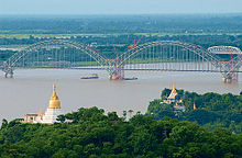
Sagaing
Hemmed in by two great rivers of Myanmar, the Irrawaddy and the Chindwin, river transport is a common way to move people and cargo. Much of the inland Sagaing Region relies on roads and rail in poor condition.
Economy
Agriculture is the chief occupation. The leading crop is rice, which occupies most of the arable ground. Other crops include wheat, sesame, peanut, pulses, cotton, and tobacco. Sagaing is Myanmar’s leading producer of wheat, contributing more than 80% of the country's total production. Forestry is important in the wetter upper regions along the Chindwin River, with teak and other hardwoods extracted. As in other parts of the country, reforestation is not effective enough to maintain sustainable forestry. Important minerals include gold, coal, salt and small amounts of petroleum. Industry includes textiles, copper refining, gold smelting, and a diesel engine plant. The Region has many rice mills, edible oil mills, saw mills, cotton mills, and mechanized weaving factories. Local industry includes earthen pots, silverware, bronze-wares, iron-wares and lacquerware.
Education
Educational opportunities in Myanmar are extremely limited outside the main cities of Yangon and Mandalay. According to official statistics, less than 10% of primary school students in Sagaing Region reach high school.[13]
| AY 2002–2003 | Primary | Middle | High |
|---|---|---|---|
| Schools | 3854 | 190 | 84 |
| Teachers | 16,100 | 5000 | 1600 |
| Students | 550,000 | 140,000 | 49,000 |
Sagaing Region has two national "professional" universities in the Monywa Institute of Economics and the Sagaing Institute of Education. Monywa University is the main liberal arts university in the region.
Health care
The general state of health care in Myanmar is poor. The military government spends anywhere from 0.5% to 3% of the country's GDP on health care, consistently ranking among the lowest in the world.[14][15] Although health care is nominally free, in reality, patients have to pay for medicine and treatment, even in public clinics and hospitals. Public hospitals lack many of the basic facilities and equipment. Moreover, the health care infrastructure outside of Yangon and Mandalay is extremely poor. In 2003, Sagaing Region had less than a quarter of the number of hospital beds counted in Yangon Region, with a similar size of population.[16]
| 2002–2003 | # Hospitals | # Beds |
|---|---|---|
| Specialist hospitals | 0 | 0 |
| General hospitals with specialist services | 2 | 400 |
| General hospitals | 38 | 1168 |
| Health clinics | 48 | 768 |
Total | 88 | 2336 |
References
^ ab Census Report. The 2014 Myanmar Population and Housing Census. 2. Naypyitaw: Ministry of Immigration and Population. May 2015. p. 17..mw-parser-output cite.citationfont-style:inherit.mw-parser-output .citation qquotes:"""""""'""'".mw-parser-output .citation .cs1-lock-free abackground:url("//upload.wikimedia.org/wikipedia/commons/thumb/6/65/Lock-green.svg/9px-Lock-green.svg.png")no-repeat;background-position:right .1em center.mw-parser-output .citation .cs1-lock-limited a,.mw-parser-output .citation .cs1-lock-registration abackground:url("//upload.wikimedia.org/wikipedia/commons/thumb/d/d6/Lock-gray-alt-2.svg/9px-Lock-gray-alt-2.svg.png")no-repeat;background-position:right .1em center.mw-parser-output .citation .cs1-lock-subscription abackground:url("//upload.wikimedia.org/wikipedia/commons/thumb/a/aa/Lock-red-alt-2.svg/9px-Lock-red-alt-2.svg.png")no-repeat;background-position:right .1em center.mw-parser-output .cs1-subscription,.mw-parser-output .cs1-registrationcolor:#555.mw-parser-output .cs1-subscription span,.mw-parser-output .cs1-registration spanborder-bottom:1px dotted;cursor:help.mw-parser-output .cs1-ws-icon abackground:url("//upload.wikimedia.org/wikipedia/commons/thumb/4/4c/Wikisource-logo.svg/12px-Wikisource-logo.svg.png")no-repeat;background-position:right .1em center.mw-parser-output code.cs1-codecolor:inherit;background:inherit;border:inherit;padding:inherit.mw-parser-output .cs1-hidden-errordisplay:none;font-size:100%.mw-parser-output .cs1-visible-errorfont-size:100%.mw-parser-output .cs1-maintdisplay:none;color:#33aa33;margin-left:0.3em.mw-parser-output .cs1-subscription,.mw-parser-output .cs1-registration,.mw-parser-output .cs1-formatfont-size:95%.mw-parser-output .cs1-kern-left,.mw-parser-output .cs1-kern-wl-leftpadding-left:0.2em.mw-parser-output .cs1-kern-right,.mw-parser-output .cs1-kern-wl-rightpadding-right:0.2em
^ "Sub-national HDI - Area Database - Global Data Lab". hdi.globaldatalab.org. Retrieved 2018-09-13.
^ http://www.mrtv3.net.mm/newpaper/68newsm.pdf Page 3 Col 1
^ ab "Myanmar States/Divisions & Townships Overview Map" Myanmar Information Management Unit (MIMU)
^ "The page cannot be found" (PDF). archive.org. 25 September 2007. Archived from the original (PDF) on 25 September 2007. Retrieved 19 April 2018.
^ ab "တိုင်းခုနစ်တိုင်းကို တိုင်းဒေသကြီးများအဖြစ် လည်းကောင်း၊ ကိုယ်ပိုင်အုပ်ချုပ်ခွင့်ရ တိုင်းနှင့် ကိုယ်ပိုင်အုပ်ချုပ်ခွင့်ရ ဒေသများ ရုံးစိုက်ရာ မြို့များကို လည်းကောင်း ပြည်ထောင်စုနယ်မြေတွင် ခရိုင်နှင့်မြို့နယ်များကို လည်းကောင်း သတ်မှတ်ကြေညာ". Weekly Eleven News (in Burmese). 2010-08-20. Retrieved 2010-08-23.
^ ပြည်ထောင်စုသမ္မတမြန်မာနိုင်ငံတော် ဖွဲ့စည်းပုံအခြေခံဥပဒေ (၂၀၀၈ ခုနှစ်) (in Burmese) [0]=1|2008 Constitution PDF Archived 2011-05-01 at the Wayback Machine
^ Department of Population Ministry of Labour, Immigration and Population MYANMAR (July 2016). The 2014 Myanmar Population and Housing Census Census Report Volume 2-C. Department of Population Ministry of Labour, Immigration and Population MYANMAR. pp. 12–15.
^ Aung, Myint (2001) "Ecology and Social Organization of a Tropical Deer (Cervus Eldi Thamin)" Journal of Mammalogy 82(3): pp. 836–847, doi:10.1644/1545-1542(2001)082<0836:EASOOA>2.0.CO;2
^ "Mahamyaing Wildlife Sanctuary" BirdLife IBA Factsheet
^ Brockelman, Warren Y. et al. (2009) "Chapter 20: Census of Eastern Hoolock Gibbons (Hoolock leuconedys) in Mahamyaing Wildlife Sanctuary, Sagaing Region, Myanmar" pp. 435–451 In Lappan, Susan and Whittaker, Danielle (eds.) (2009) The Gibbons: New Perspectives on Small Ape Socioecology and Population Biology Springer, New York,
ISBN 978-0-387-88603-9, doi:10.1007/978-0-387-88604-6_20
^ "Htamanthi Wildlife Sanctuary" BirdLife IBA Factsheet
^ "Education statistics by level and by State and Division". Myanmar Central Statistical Organization. Archived from the original on 2011-09-29. Retrieved 2009-04-09.
^ "PPI: Almost Half of All World Health Spending is in the United States". 2007-01-17. Archived from the original on 2008-02-05.
^ Yasmin Anwar (2007-06-28). "Burma junta faulted for rampant diseases". UC Berkeley News.
^ "Hospitals and Dispensaries by State and Division". Myanmar Central Statistical Organization. Archived from the original on 2011-09-29. Retrieved 2009-04-11.
Places adjacent to Sagaing Region | ||||||||||
|---|---|---|---|---|---|---|---|---|---|---|
| ||||||||||
Sagaing Region | ||
|---|---|---|
Capital: Sagaing | ||
| Hkamti District |
|   |
| Kanbalu District |
| |
| Kale District |
| |
| Katha District |
| |
| Mawlaik District |
| |
| Monywa District |
| |
| Sagaing District |
| |
| Shwebo District |
| |
| Tamu District |
| |
| Yinmabin District |
| |
Naga Self-Administered Zone1 |
| |
1 - also part of Hkamti District | ||
Administrative divisions of Myanmar | ||
|---|---|---|
| States |
| |
| Regions |
| |
| Self-Administered Zones |
| |
| Self-Administered Divisions |
| |
| Union Territories |
| |


