Midori-ku, Sagamihara
Midori .mw-parser-output .noboldfont-weight:normal 緑区 | |
|---|---|
Ward | |
| Midori Ward | |
 Sagami Lake | |
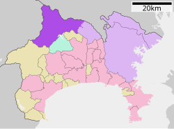 Map of Midori-ku, Sagamihara | |
 Midori | |
| Coordinates: 35°35′45″N 139°20′41″E / 35.59583°N 139.34472°E / 35.59583; 139.34472Coordinates: 35°35′45″N 139°20′41″E / 35.59583°N 139.34472°E / 35.59583; 139.34472 | |
| Country | Japan |
| Region | Kantō |
| Prefecture | Kanagawa |
| City | Sagamihara |
| Area | |
| • Total | 253.8 km2 (98.0 sq mi) |
| Population (March 1, 2010) | |
| • Total | 174,784 |
| • Density | 688.67/km2 (1,783.6/sq mi) |
| Time zone | UTC+9 (Japan Standard Time) |
| Phone number | 042-775-8802 |
| Address | 2-1, Hashimoto 6-chōme, Midori-Ku, Sagamihara-shi Kanagawa-ken 252-5177 |
| Website | Midori-ku home page |
City Plaza Hashimoto, housing the Sagamihara Midori-ku Ward Office
Midori-ku (緑区, Midori-ku) is one of three wards of Sagamihara, Kanagawa, Japan. It's located in the western part of the city and covers about 77% of city's area. To the east Midori-ku faces Chūō-ku and to the north faces Machida and Hachiōji.
Midori-ku was created on April 1, 2010 when Sagamihara became a city designated by government ordinance (a "designated city").
As of March 2010, Midori-ku had a population of 174,784, with a land area of 253.8 square kilometers.
| Wikimedia Commons has media related to Midori-ku, Sagamihara. |
Yokohama (capital) | ||
Wards of Yokohama |
| |
| Wards of Kawasaki |
| |
| Wards of Sagamihara |
| |
| Core city |
| |
| Special cities |
| |
| Cities |
| |
| Districts |
| |
| ||
This Kanagawa Prefecture location article is a stub. You can help Wikipedia by expanding it. |


