Cape Province
| Province of the Cape of Good Hope Provinsie van die Kaap die Goeie Hoop | |
|---|---|
 | |
 | |
| Population | |
| • 1991 | 6,125,335[1] |
| History | |
| • Origin | Cape Colony |
| • Created | 31 May 1910 |
| • Abolished | 27 April 1994 |
| • Succeeded by | Western Cape, Eastern Cape, Northern Cape, North West |
| Status | Province of South Africa |
| Government | Cape Provincial Council |
| • HQ | Cape Town |
| Subdivisions | |
| • Type | Districts |
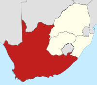
The Province of the Cape of Good Hope[2] (Afrikaans: Provinsie van die Kaap die Goeie Hoop), commonly referred to as the Cape Province (Afrikaans: Kaapprovinsie) and colloquially as The Cape (Afrikaans: Die Kaap), was a province in the Union of South Africa and subsequently the Republic of South Africa. It encompassed the old Cape Colony, and had Cape Town as its capital. Following the end of the Apartheid era, the Cape Province was split up to form the new Eastern Cape, Northern Cape and Western Cape provinces, along with part of the North West.
Contents
1 History
1.1 Cape Franchise
1.2 Partitioning under Apartheid
1.3 Post Apartheid history
2 Districts in 1991
3 Administrators
4 See also
5 References
6 External links
History
When the Union of South Africa was formed in 1910, the original Cape Colony was renamed the Cape Province.
It was by far the largest of South Africa's four provinces, as it contained regions it had previously annexed, such as British Bechuanaland (not to be confused with the Bechuanaland Protectorate, now Botswana), Griqualand East (the area around Kokstad) and Griqualand West (area around Kimberley). As a result, it encompassed two-thirds of South Africa's territory, and covered an area similar in size to the US state of Texas.
At the time of the formation of the Union of South Africa, South Africa consisted of four provinces: Transvaal (South African Republic), Natal (Natalia Republic), Orange Free State and the Cape Province.
Cape Franchise
Before union, the Cape Colony had traditionally implemented a system of non-racial franchise, whereby qualifications for suffrage were applied equally to all males, regardless of race. During the union negotiations, the Cape Prime Minister, John X. Merriman fought unsuccessfully to extend this multi-racial franchise system to the rest of South Africa. This failed, as it was strongly opposed by the other constituent states which were determined to entrench white rule.
After union, the Cape Province was permitted to keep a restricted version of its multi-racial qualified franchise, and thus became the only province where coloureds (mixed-race people) and Black Africans could vote.[3][4]
Over the following years, successive acts were passed to erode this colour-blind voters roll.
In 1931, the restricting franchise qualifications were removed for white voters, but kept for Black and Coloured voters.[5] In 1956, the Apartheid government removed all remaining suffrage rights for "non-whites". The government had to appoint many extra senators in parliament to force through this change.
[6]
Partitioning under Apartheid
During the apartheid era the country was divided into a number of additional pieces which were known as the four TBVC States and the six Non-Independent Homelands. These were created by the apartheid government to enforce its policy of racial segregation.[citation needed]
Griqualand East was transferred to Natal Province after the Transkei was declared independent, since it was cut off from the rest of the province. The Transkei (1976) and Ciskei (1981) regions were declared independent of South Africa, after they were formerly part of the Cape Province. (They were re-incorporated into South Africa in 1994, both part of the new Eastern Cape province).[7]
Post Apartheid history
After the first fully democratic elections in 1994, these "bantustans" were reunited with the rest of the country, which was then divided into what are now the current nine provinces of South Africa.
The Cape Province was broken up into three smaller provinces: the Western Cape, Eastern Cape and Northern Cape. Parts of it were also absorbed into the North West. Walvis Bay, a territory of the original Cape Colony, was ceded to Namibia.
Districts in 1991
Districts of the province and population at the 1991 census.[1]
Aberdeen: 8,009
Adelaide: 15,220
Albany: 69,705
Albert (main town Burgersdorp): 16,995
Alexandria: 26,651
Aliwal-Noord: 27,486
Barkly-Oos: 12,821
Barkly-Wes: 35,012
Bathurst: 32,419
Beaufort-Wes: 31,726
Bedford: 16,074
Bellville: 269,995
Bredasdorp: 23,076
Britstown: 6,523
Caledon: 79,052
Calitzdorp: 6,759
Calvinia: 18,430
Cape: 179,537
Carnarvon: 9,728
Cathcart: 14,815
Ceres: 47,052
Clanwilliam: 28,144
Colesberg: 15,446
Cradock: 37,144
De Aar: 25,438
Oos-Londen: 240,474
Elliot: 14,159
Fort Beaufort: 22,793
Fraserburg: 4,367
George: 95,597
Goodwood: 259,620
Gordonia (main town Upington):[8] 118,623
Graaff-Reinet: 34,440
Hankey: 24,548
Hanover: 4,399
Hartswater: 29,146
Hay (main town Griquatown):[9] 11,104
Heidelberg: 11,519
Herbert (main town Douglas):[10] 26,316
Hermanus: 21,610
Hofmeyr: 4,995
Hopefield: 8,822
Hopetown: 11,175
Humansdorp: 43,799
Indwe: 9,483
Jansenville: 9,797
Joubertina: 13,385
Kenhardt: 11,353
Kimberley: 167,060
King William's Town: 29,653
Kirkwood: 30,766
Knysna: 50,420
Komga: 14,142
Kuilsrivier: 133,577
Kuruman: 24,817
Ladismith: 12,705
Lady Grey: 7,530
Laingsburg: 5,781
Maclear: 16,653
Malmesbury: 113,450
Middelburg: 21,737
Molteno: 11,702
Montagu: 21,674
Moorreesburg: 11,159
Mosselbaai: 59,170
Murraysburg: 5,960
Namakwaland (main town Springbok): 62,536
Noupoort: 8,348
Oudtshoorn: 68,093
Paarl: 136,121
Pearston: 4,983
Philipstown: 8,799
Piketberg: 34,152
Port Elizabeth: 670,653
Postmasburg: 54,790
Prieska: 19,185
Prince Albert: 8,567
Queenstown: 44,469
Richmond: 6,326
Riversdal: 25,021
Robertson: 32,331
Simonstad: 58,323
Somerset-Oos: 29,758
Somerset-Wes: 59,947
Stellenbosch: 73,839
Sterkstroom: 7,687
Steynsburg: 10,593
Steytlerville: 5,341
Strand: 40,096
Stutterheim: 40,119
Sutherland: 3,596
Swellendam: 32,147
Tarka: 9,538
Tulbagh: 25,334
Uitenhage: 182,551
Uniondale: 9,354
Vanrhynsdorp: 12,815
Venterstad: 5,777
Victoria West: 11,910
Vredenburg: 39,908
Vredendal: 28,962
Vryburg: 98,551
Walvisbaai (South African 1878–1994): 22,999
Warrenton: 22,368
Wellington: 37,432
Williston: 4,177
Willowmore: 10,734
Wodehouse (main town Dordrecht):[11] 15,540
Worcester: 117,159
Wynberg: 1,101,668
Administrators
See also
- Provinces of South Africa
References
^ ab "Census > 1991 > RSA > Variable Description > Person file > District code". Statistics South Africa – Nesstar WebView. Retrieved 18 August 2013..mw-parser-output cite.citationfont-style:inherit.mw-parser-output qquotes:"""""""'""'".mw-parser-output code.cs1-codecolor:inherit;background:inherit;border:inherit;padding:inherit.mw-parser-output .cs1-lock-free abackground:url("//upload.wikimedia.org/wikipedia/commons/thumb/6/65/Lock-green.svg/9px-Lock-green.svg.png")no-repeat;background-position:right .1em center.mw-parser-output .cs1-lock-limited a,.mw-parser-output .cs1-lock-registration abackground:url("//upload.wikimedia.org/wikipedia/commons/thumb/d/d6/Lock-gray-alt-2.svg/9px-Lock-gray-alt-2.svg.png")no-repeat;background-position:right .1em center.mw-parser-output .cs1-lock-subscription abackground:url("//upload.wikimedia.org/wikipedia/commons/thumb/a/aa/Lock-red-alt-2.svg/9px-Lock-red-alt-2.svg.png")no-repeat;background-position:right .1em center.mw-parser-output .cs1-subscription,.mw-parser-output .cs1-registrationcolor:#555.mw-parser-output .cs1-subscription span,.mw-parser-output .cs1-registration spanborder-bottom:1px dotted;cursor:help.mw-parser-output .cs1-hidden-errordisplay:none;font-size:100%.mw-parser-output .cs1-visible-errorfont-size:100%.mw-parser-output .cs1-subscription,.mw-parser-output .cs1-registration,.mw-parser-output .cs1-formatfont-size:95%.mw-parser-output .cs1-kern-left,.mw-parser-output .cs1-kern-wl-leftpadding-left:0.2em.mw-parser-output .cs1-kern-right,.mw-parser-output .cs1-kern-wl-rightpadding-right:0.2em
^ South Africa Act, 1909 §6 (Wikisource)
^ http://www.eisa.org.za/WEP/souoverview5.htm
^ "Archived copy" (PDF). Archived from the original (PDF) on 17 May 2006. Retrieved 6 July 2012.CS1 maint: Archived copy as title (link)
^ http://www.eisa.org.za/WEP/soubg2.htm
^ Christoph Marx: Oxwagon Sentinel: Radical Afrikaner Nationalism and the History of the Ossewabrandwag. LIT Verlag Münster, 2009. p.61.
^ "The Homelands". South African History Online. Retrieved 31 December 2017.
^ "Dictionary of Southern African Place Names (Public Domain)". Human Science Research Council. p. 182.
^ "Dictionary of Southern African Place Names (Public Domain)". Human Science Research Council. p. 200.
^ "Dictionary of Southern African Place Names (Public Domain)". Human Science Research Council. p. 205.
^ "Dictionary of Southern African Place Names (Public Domain)". Human Science Research Council. p. 478.
External links
Wikisource has the text of the 1911 Encyclopædia Britannica article Cape Colony. |
- A history of the Cape Province
- Archives kept at Cape Town
Administrative divisions of South Africa (1910–1994) | ||
|---|---|---|
| Provinces of South Africa |
|  |
| Non-independent homelands |
| |
| Independent homelands1 |
| |
| Dependent territories |
| |
| ||
Coordinates: 31°00′S 22°00′E / 31.000°S 22.000°E / -31.000; 22.000
Authority control |
|
|---|


