Nishiseto Expressway
Nishiseto Expressway | |
|---|---|
| Route information | |
| Length | 59.4 km (36.9 mi) |
| Existed | 1979-2006–present |
| Major junctions | |
| From | Nishiseto Onomichi Interchange in Onomichi, Hiroshima |
| To | Imabari Interchange in Imabari, Ehime |
| Highway system | |
National highways of Japan Expressways of Japan | |
The Nishiseto Expressway (西瀬戸自動車道, Nishiseto Jidōsha-dō), often called the Shimanami Kaidō (しまなみ海道) is an expressway in Japan that connects Onomichi, Hiroshima and Imabari, Ehime, going through nine of the Geiyo Islands, including Ōshima, Umashima, and Innoshima. The road and multiple bridge crossing across the Seto Inland Sea is one of the three main transportation links of the Honshū–Shikoku Bridge Project constructed between the islands of Honshu and Shikoku.
The expressway contains fifty-five bridges, including the Kurushima-Kaikyō Bridge, the world's longest series of suspension bridges, and the Tatara Bridge, the world's fourth longest cable-stayed bridge. The route is famed for its scenic views and can be crossed by bicycles, mopeds and pedestrians as well as cars. It was opened on May 1, 1999, and is 59.4 kilometres (36.9 miles) long, sporting four lanes with a separated path for pedestrians and cyclists.[1]
Contents
1 Cycle Tourism
1.1 Gallery
2 See also
3 References
4 External links
Cycle Tourism
The road and bridge route was designed with an integrated cycle lane linking Onomichi in Hiroshima Prefecture with Imabari in Ehime Prefecture. The cycle route is approximately 70 kilometres (43 miles) in length including bridge access ramps and since opening has become one of Japan's most popular long-distance cycle routes.
As accessing the Shin-Onomichi bridge involves a steep climb, cyclists are encouraged to use a short ferry between Onomichi and Mukaishima, but all other bridges on the route feature a designated cycle path. Bicycle rental and drop off locations are available along the route.[2]
The route is a toll road, but tolls were waived for cyclists until March 31, 2020, in an effort to promote tourism.[3]
Gallery
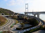
Cycle access ramp to the Kurushima-kaikyo Ohashi Bridge
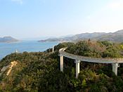
Shimanami Kaido cycle access ramp at Imabari
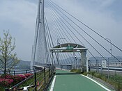
Designated cycle lane on the Tatara Bridge
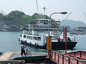
Onomichi ferry. Northern starting point of Shimanami Kaido cycle route.


See also
- Expressways of Japan
- Honshū-Shikoku Bridge Project
References
^ "E76 SHIMANAMI EXPWY(Nishi-Seto Expressway)". Honshu-Shikoku Bridge Expressway Company. Retrieved 14 April 2018..mw-parser-output cite.citationfont-style:inherit.mw-parser-output .citation qquotes:"""""""'""'".mw-parser-output .citation .cs1-lock-free abackground:url("//upload.wikimedia.org/wikipedia/commons/thumb/6/65/Lock-green.svg/9px-Lock-green.svg.png")no-repeat;background-position:right .1em center.mw-parser-output .citation .cs1-lock-limited a,.mw-parser-output .citation .cs1-lock-registration abackground:url("//upload.wikimedia.org/wikipedia/commons/thumb/d/d6/Lock-gray-alt-2.svg/9px-Lock-gray-alt-2.svg.png")no-repeat;background-position:right .1em center.mw-parser-output .citation .cs1-lock-subscription abackground:url("//upload.wikimedia.org/wikipedia/commons/thumb/a/aa/Lock-red-alt-2.svg/9px-Lock-red-alt-2.svg.png")no-repeat;background-position:right .1em center.mw-parser-output .cs1-subscription,.mw-parser-output .cs1-registrationcolor:#555.mw-parser-output .cs1-subscription span,.mw-parser-output .cs1-registration spanborder-bottom:1px dotted;cursor:help.mw-parser-output .cs1-ws-icon abackground:url("//upload.wikimedia.org/wikipedia/commons/thumb/4/4c/Wikisource-logo.svg/12px-Wikisource-logo.svg.png")no-repeat;background-position:right .1em center.mw-parser-output code.cs1-codecolor:inherit;background:inherit;border:inherit;padding:inherit.mw-parser-output .cs1-hidden-errordisplay:none;font-size:100%.mw-parser-output .cs1-visible-errorfont-size:100%.mw-parser-output .cs1-maintdisplay:none;color:#33aa33;margin-left:0.3em.mw-parser-output .cs1-subscription,.mw-parser-output .cs1-registration,.mw-parser-output .cs1-formatfont-size:95%.mw-parser-output .cs1-kern-left,.mw-parser-output .cs1-kern-wl-leftpadding-left:0.2em.mw-parser-output .cs1-kern-right,.mw-parser-output .cs1-kern-wl-rightpadding-right:0.2em
^ "Shimanami Kaido Tourist Information". Shimap. Retrieved 4 April 2016.
^ "Onomichi Travel: Shimanami Kaido". www.japan-guide.com. Retrieved 4 May 2017.
External links
| Wikimedia Commons has media related to Nishiseto Expressway. |
| Wikivoyage has a travel guide for Shimanami Kaido Bikeway. |
- Nishiseto Expressway at the Honshu-Shikoku Bridge Authority
- Shimanami Kaido Cycle Route Information in English
| East Nippon Expressway Company |
|
|---|---|
| Central Nippon Expressway Company |
|
| West Nippon Expressway Company |
|
| Honshū-Shikoku Bridge Expressway Company |
|
| MLIT |
|
| Urban Expressways |
|
This article relating to the roads and highways in Japan is a stub. You can help Wikipedia by expanding it. |
This article about a Japanese corporation– or company–related topic is a stub. You can help Wikipedia by expanding it. |


