Downtown Winnipeg
Coordinates: 49°53′42″N 97°08′17″W / 49.895°N 97.138°W / 49.895; -97.138

View of Downtown Winnipeg from The Forks.
Downtown Winnipeg is an area of the city located near the confluence of the Red and Assiniboine rivers. It is the oldest urban area in Winnipeg, and is home to the city's commercial core, city hall, the seat of Manitoba's provincial government, and a number of major attractions and institutions.
The City of Winnipeg's official downtown boundaries are: the Canadian Pacific Railway mainline on the north, Gomez Street and the Red River on the east, and the Assiniboine River on the south. The western boundaries are downtown are irregular, following along a number of different streets, back lanes, and across properties.[1] Generally speaking, the western boundaries are rarely further west of Balmoral and Isabel Streets. In 2016, Canadian Geographic produced a map that generalize Winnipeg's downtown boundaries.[2]
Neighbourhoods in the downtown area include the Exchange District, Central Park, The Forks, and Chinatown. The downtown area is roughly three square kilometres. Winnipeg Square, Bell MTS Place, Portage Place, and the flagship store of the Bay are all located on the downtown section of Portage Avenue. On Main Street are Winnipeg's City Hall, Union Station, and the Manitoba Centennial Centre, which includes the Manitoba Museum, the Planetarium, the Centennial Concert Hall and the Winnipeg Railway Museum. Although over 60,000 people work downtown, only 13,470 people actually live in the Downtown area.[3]
There are several residential projects under construction on Waterfront Drive and in the Exchange District, and the residential population of the area is projected to increase substantially in the next few years.
Contents
1 Neighbourhoods
1.1 Waterfront District
1.2 Central Park
1.3 Exchange District
1.4 Broadway-Assiniboine
1.5 The Forks
1.6 South Portage
1.7 Chinatown
2 Winnipeg Walkway System
3 See also
4 Notes
5 References
6 External links
Neighbourhoods
The Downtown Winnipeg Zoning By-Law defines the boundaries of the Downtown planning area, and several sectors within it. The downtown census area is slightly smaller, omitting a three-block extension at the north edge. There is also a significantly larger Downtown community area, used for Community Social Data Strategy for Winnipeg.[4][5]
Waterfront District

Condominiums in the Waterfront District. The district is situated in the northeast corner of Downtown.
The Waterfront District is a newly emerging district located in the northeast corner of downtown Winnipeg. The area runs along the west bank of the Red River along the recently built Waterfront Drive and features Stephen Juba Park.
The Waterfront district has seen a number of residential construction projects since 2005.[6]
Sunstone Boutique Hotels has an $11-million plan to build a three-storey, 67-room boutique hotel on what is now a gravel parking lot, along with a new casual-dining restaurant in the one-storey brick former Harbourmaster's building. The plans also involve construction of a public plaza area at the south end of the property.[6][7]
Central Park
Central Park is one of Winnipeg's most densely populated neighbourhoods with 13,755 people per square km according to Statistics Canada's 2001 Census. Seventy per cent of all refugees coming to Winnipeg live downtown, in and around the Central Park area. Central Park includes many different ethnicities including Arabs, Vietnamese, Chinese, Ojibway, Filipinos, and African (more than half being African).
With the increase in the African population, Central Park has been transforming in recent years. It is now the home to the 'Central Market', with more markets planned to come. Many of the markets will sell handmade fashion and imported African crafts.
During warm Saturday nights, live entertainment fills the air, residents enjoy free Sunday movie screenings to enjoy an evening outdoors. The Knox Centre at Knox United Church presents international films in various languages - with English subtitles - every Thursday evening.
Exchange District

Notre Dame Avenue in the Exchange District, a district in Downtown Winnipeg, and a National Historic Site of Canada.
The Exchange District is a National Historic Site of Canada. Just one block north is one of Canada's most famous intersections, Portage and Main, the Exchange District comprises twenty city blocks and approximately 150 heritage buildings,[8] and it is known for its intact turn-of-the-century collection of warehouses, financial institutions, and early terra cotta clad skyscrapers.[9]
Winnipeg's theatre district is located on the east side of the Exchange District, home to the Royal Manitoba Theatre Centre, and Centennial Concert Hall which houses the Winnipeg Symphony Orchestra, the Royal Winnipeg Ballet, and the Manitoba Opera.[10] The west side of the Exchange is home to Cinematheque, a small movie theatre located in the Artspace building on Albert Street.[11]
The Exchange District's Old Market Square annually hosts the Jazz Winnipeg Festival, the Winnipeg Fringe Theatre Festival, and the Manitoba Electronic Music Exhibition. Renovations to Old Market Square completed in 2012 added "The Cube", a new $1.5 million stage, with a skin made up of 20,000 aluminum links.[12] The stage contains a built-in lighting system, green room and two performance levels.[12]
The district is home to Red River College's Roblin Centre[13] and Paterson Globalfoods Institute.[14]
Broadway-Assiniboine
Broadway-Assiniboine lies in the southern part of downtown on the north bank of the Assiniboine River. The neighbourhood is one of the more densely populated in Winnipeg, with 14,895 people per square kilometre.[15] It features many notable landmarks such as the Hotel Fort Garry and the Manitoba Legislative Building. Broadway-Assiniboine features the "Assiniboine Riverwalk" and is home to many notable restaurants.
The population of Broadway-Assiniboine was 5,080 as of the 2006 Census.[15] The most common transportation method of the people in South Portage is walking, with 41.1%, more than six and a half times higher than the overall 6.2% for Winnipeg.[15] The average employment income for the area is just $28,818, which is lower than Winnipeg's average employment income of $33,518.[15]
The Forks

The Forks is a historic site, and public space in Downtown Winnipeg at the confluence of the Red and Assiniboine River.
The Forks is a national historic, recreational, cultural and entertainment area site located in downtown Winnipeg where the Assiniboine and Red Rivers meet. The Forks was designated a National Historic Site of Canada in 1974 due to its status as a cultural landscape that had borne witness to six thousand years of human activity.
South Portage
South Portage is the group of blocks located between Portage Avenue, Main Street, Broadway and Memorial Boulevard.
The population of South Portage was 1,860 as of the 2006 Census.[16] The most common transportation method of the people in South Portage is walking, with 34.4%, more than five times higher than the overall 6.2% for Winnipeg.[16] The average employment income for the area is just $24,856, which is lower than Winnipeg's average employment income of $33,518.[16]
South Portage is the home of the main branch of the Winnipeg Public Library system, the four-storey Millennium Library.[17] The area also boasts the Winnipeg Convention Centre which features 160,000 square feet (15,000 m2) of meeting, exhibition and banquet space.[18] Opened in 2004, Winnipeg's MTS Centre is located just south of Portage Avenue and is home to the Winnipeg Jets.[19] The area also features the Law Courts, cityplace mall and VJ's Drive Inn. There are numerous office buildings and hotels in this area, including some of Winnipeg's tallest buildings.
Winnipeg's public transit hub is located on the Graham Avenue Transit Mall, as many bus routes converge there.
Chinatown
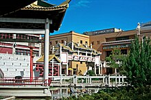
Formed in 1909, Chinatown is an ethnic enclave located in Downtown Winnipeg.
Formed in 1909,[20] the area is home to many shops and restaurants including Asian grocery stores and an herbal products store.[20]
Winnipeg's Chinatown covers 0.1 square kilometres (0.039 sq mi) northwest of City Hall and is home to about 600 people, of whom 90% are in the Chinese visible minority group.[21] 40.5% of the area's residents speak neither English nor French (as compared to 1% of Winnipeg as a whole), while 71.1% of residents speak some variant of Chinese (including Cantonese, Mandarin and Chinese not otherwise specified).[21]
Winnipeg Walkway System
The Winnipeg Walkway System, popularly known as the Winnipeg Skywalk, is a network of pedestrian skyways and tunnels connecting a significant portion of the city centre.[22]
See also
- List of tallest buildings in Winnipeg
Notes
^ "Map for OurWinnipeg Adopted by City Council". Retrieved 2 April 2018..mw-parser-output cite.citationfont-style:inherit.mw-parser-output .citation qquotes:"""""""'""'".mw-parser-output .citation .cs1-lock-free abackground:url("//upload.wikimedia.org/wikipedia/commons/thumb/6/65/Lock-green.svg/9px-Lock-green.svg.png")no-repeat;background-position:right .1em center.mw-parser-output .citation .cs1-lock-limited a,.mw-parser-output .citation .cs1-lock-registration abackground:url("//upload.wikimedia.org/wikipedia/commons/thumb/d/d6/Lock-gray-alt-2.svg/9px-Lock-gray-alt-2.svg.png")no-repeat;background-position:right .1em center.mw-parser-output .citation .cs1-lock-subscription abackground:url("//upload.wikimedia.org/wikipedia/commons/thumb/a/aa/Lock-red-alt-2.svg/9px-Lock-red-alt-2.svg.png")no-repeat;background-position:right .1em center.mw-parser-output .cs1-subscription,.mw-parser-output .cs1-registrationcolor:#555.mw-parser-output .cs1-subscription span,.mw-parser-output .cs1-registration spanborder-bottom:1px dotted;cursor:help.mw-parser-output .cs1-ws-icon abackground:url("//upload.wikimedia.org/wikipedia/commons/thumb/4/4c/Wikisource-logo.svg/12px-Wikisource-logo.svg.png")no-repeat;background-position:right .1em center.mw-parser-output code.cs1-codecolor:inherit;background:inherit;border:inherit;padding:inherit.mw-parser-output .cs1-hidden-errordisplay:none;font-size:100%.mw-parser-output .cs1-visible-errorfont-size:100%.mw-parser-output .cs1-maintdisplay:none;color:#33aa33;margin-left:0.3em.mw-parser-output .cs1-subscription,.mw-parser-output .cs1-registration,.mw-parser-output .cs1-formatfont-size:95%.mw-parser-output .cs1-kern-left,.mw-parser-output .cs1-kern-wl-leftpadding-left:0.2em.mw-parser-output .cs1-kern-right,.mw-parser-output .cs1-kern-wl-rightpadding-right:0.2em
^ "Six maps that put Canada's downtown cores in context". Retrieved 2 April 2018.
^ "Residential Development Strategy" (PDF). The City of Winnipeg. 2011.
^ "(UD) : 2001 Census". Winnipeg.ca. Retrieved 2011-01-26.
^ [1] 2006 Census data
^ ab McNeill, Murray (4 July 2011). "Waterfront set for leap forward". Winnipeg Free Press. Retrieved 16 October 2012.
^ "HARBOUR MASTER HOTEL LANDSCAPE CONCEPT PLAN". February 2011. Retrieved 16 October 2012.
^ "Historic Exchange". Retrieved 20 August 2012.
^ "The Exchange District A National Historic Site Heritage Interpretation Strategy" (PDF). The Exchange District Heritage Partnership. July 1999. p. 12. Retrieved 21 September 2012.
^ "Theatres". The Exchange District. Archived from the original on 24 February 2013. Retrieved 21 September 2012.
^ "Cinematheque". Cinematheque. Archived from the original on 21 September 2012. Retrieved 21 September 2012.
^ ab "Old Market Square". Winnipeg Downtown Places. 19 June 2010. Retrieved 20 August 2012.
^ "The Roblin Centre". Red River College. Archived from the original on 2 November 2012. Retrieved 21 September 2012.
^ McNabb, Lauren (27 April 2012). "Breathing new life into historic Exchange District building". Global Winnipeg. Retrieved 12 September 2012.
^ abcd "2006 Census Data Broadway-Assiniboine" (PDF). City of Winnipeg. Retrieved 16 October 2012.
^ abc "2006 Census Data South Portage" (PDF). City of Winnipeg. Retrieved 16 October 2012.
^ "Winnipeg Millennium Library". LM Architectural Group. Retrieved 16 October 2012.
^ "Winnipeg Convention Centre". Winnipeg Convention Centre. Archived from the original on 29 October 2012. Retrieved 16 October 2012.
^ "MTS Centre / True North Arena". MTS Centre. Archived from the original on 17 June 2012. Retrieved 16 October 2012.
^ ab http://www.tourismwinnipeg.com/visitors/neighbourhoods/chinatown
^ ab "2006 Census Data China Town" (PDF). 2006 Census Data. City of Winnipeg. Retrieved 11 October 2012.
^ "INDOOR WALKWAYS". Downtown Winnipeg Biz. Archived from the original on 31 December 2008. Retrieved 10 August 2012.
References
- Downtown Winnipeg Zoning By-law No. 100/2004
External links
| Wikimedia Commons has media related to Downtown Winnipeg. |
- City of Winnipeg Site
- CentreVenture Site
- Downtown Winnipeg Plan (1969)
- Downtown Winnipeg BIZ Site


