Mutsamudu
Mutsamudu | |
|---|---|
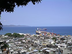 | |
 Mutsamudu Location of Mutsamudu on the island of Anjouan | |
| Coordinates: 12°10′S 44°24′E / 12.167°S 44.400°E / -12.167; 44.400 | |
| Country | |
| Island | Anjouan |
| Founded | 1482 |
| Government | |
| • Mayor | Sitti Echat Assadi |
| • Local councillor, legal advisor in charge of the local police. | Ali Zamir |
| Area | |
| • Total | 30 km2 (10 sq mi) |
| Population (2010) | |
| • Total | 25,471[1] |
| Time zone | UTC+3 (Eastern Africa Time) |
| Area code(s) | 269 |
Mutsamudu is the second largest city in the Comoros, founded in 1482.[2] It is also the capital and largest city on the island of Anjouan as well the former home of former Comorian president Ahmed Abdallah Mohamed Sambi. It now houses a deep water port, an ancient citadel, and narrow streets with many shops and small crafts. The population in 2010 stood at 25,471.
Contents
1 History
2 Geography and climate
3 Economy
4 References
History
Mutsamudu was likely founded in the first half of the second millennium by the Swahili people. By the 1700s, it was the most prosperous Swahili town in the Comoros Archipelago. During an expedition along the Swahili Coast in 1773, the commissioner Frederick Holtzappel visited the town. He expressed his admiration, noting that the houses were built with stone, whitewashed inside and out, had plank painted ceilings, and were thatched with coconut leaves. He also observed several two-story houses belonging to Swahili elites. There were numerous public baths in town, and all of the elites had baths in their houses. According to Holtzappel, the men wore white linen gowns and turbans, as well as silk clothing and daggers with silver sheaths. [3]
Geography and climate
Mutsamudu has two parallel main streets. The medina from the 15th century is located between them. The citadel was constructed in 1860 with help of the British to protect the city from pirates. It was badly damaged in 1950 at the landfall of a cyclone.[4]
Mutsamudu enjoys marine tropical weather. The main temperature range extends from 27°C to 32 °C (90 °F) throughout the year. The hottest period in Mutsamudu is from the month of December to the month of April. Comparatively cooler weather is experienced from the month of May to the month of November. There is significant rainfall in most months of the year, wettest month is January.[5]
The entire Comoros islands are regularly swept by violent winds and sometimes by tropical cyclones with significant human and material damage.[6] The most important of tropic cyclones recorded in Comoros occurred in 1950 and damaged the Mutsamudu citadel. Cyclone Elinah in 1983 and Cyclone Feliksa killed a few people but affected thousands of people's lives.[7][8]
Economy
Mutsamudu is the only deep water port of the Union of Comoros, constructed in 1982. Three quarters of its cargo consists of transhipment for containerized cargoes destined to the two other islands. The main import products shipped from the port are rice, cement, sugar, flour and petroleum products. Main export products are Ylang Ylang, cloves and vanilla.[9]
References
^ "15 3.2. Urban and Rural Population Information (p.15)" (PDF). A Practical Guide to Doing Business in COMOROS. Retrieved 17 October 2016..mw-parser-output cite.citationfont-style:inherit.mw-parser-output .citation qquotes:"""""""'""'".mw-parser-output .citation .cs1-lock-free abackground:url("//upload.wikimedia.org/wikipedia/commons/thumb/6/65/Lock-green.svg/9px-Lock-green.svg.png")no-repeat;background-position:right .1em center.mw-parser-output .citation .cs1-lock-limited a,.mw-parser-output .citation .cs1-lock-registration abackground:url("//upload.wikimedia.org/wikipedia/commons/thumb/d/d6/Lock-gray-alt-2.svg/9px-Lock-gray-alt-2.svg.png")no-repeat;background-position:right .1em center.mw-parser-output .citation .cs1-lock-subscription abackground:url("//upload.wikimedia.org/wikipedia/commons/thumb/a/aa/Lock-red-alt-2.svg/9px-Lock-red-alt-2.svg.png")no-repeat;background-position:right .1em center.mw-parser-output .cs1-subscription,.mw-parser-output .cs1-registrationcolor:#555.mw-parser-output .cs1-subscription span,.mw-parser-output .cs1-registration spanborder-bottom:1px dotted;cursor:help.mw-parser-output .cs1-ws-icon abackground:url("//upload.wikimedia.org/wikipedia/commons/thumb/4/4c/Wikisource-logo.svg/12px-Wikisource-logo.svg.png")no-repeat;background-position:right .1em center.mw-parser-output code.cs1-codecolor:inherit;background:inherit;border:inherit;padding:inherit.mw-parser-output .cs1-hidden-errordisplay:none;font-size:100%.mw-parser-output .cs1-visible-errorfont-size:100%.mw-parser-output .cs1-maintdisplay:none;color:#33aa33;margin-left:0.3em.mw-parser-output .cs1-subscription,.mw-parser-output .cs1-registration,.mw-parser-output .cs1-formatfont-size:95%.mw-parser-output .cs1-kern-left,.mw-parser-output .cs1-kern-wl-leftpadding-left:0.2em.mw-parser-output .cs1-kern-right,.mw-parser-output .cs1-kern-wl-rightpadding-right:0.2em
^ Daley, Suzanne (1997-09-29). "Indian Ocean Island Yearns to Retie Colonial Bond". New York Times. Retrieved 2008-03-29.
^ Ross, Robert, "The Dutch on the Swahili Coast, 1776-1778: Two Slaving Journals, Part I." The International Journal of African Historical Studies, Vol. 19, No. 2 (1986), pp. 305-360
^ Andrew, David (2008). Madagascar & Comoros. Lonely Planet. p. 252. ISBN 9781741046083.
^ "Climate of Mutsamudu". Climate Data org. Retrieved 17 October 2016.
^ "Climate of comoros". African Climate. Retrieved 17 October 2016.
^ "Cartography of risks and vulnerability in Comoros" (PDF). WMO. Retrieved 17 October 2016.
^ "Comoros Cyclone" (PDF). USAID. 1985. Retrieved 17 October 2016.
^ "Comoros Port of Mutsamudu - Anjouan". DLCA. Retrieved 17 October 2016.
Coordinates: 12°10′S 44°24′E / 12.167°S 44.400°E / -12.167; 44.400
This Comoros location article is a stub. You can help Wikipedia by expanding it. |


