List of Auckland railway stations

Platform at Britomart, Auckland's largest railway station.
This is a list of the railway stations in the public transport network of Auckland. It includes closed and planned stations. Auckland has 13 fare zones, with some zone overlap areas. The routes shown pass into and out of central, western, eastern, and southern zones.
Contents
1 Ownership and operation
2 Geographic map
3 Network
3.1 Southern Line
3.2 Eastern Line
3.3 Onehunga Line
3.4 Western Line
4 New stations
5 See also
6 References
Ownership and operation
Station platforms on the Auckland suburban network are owned by KiwiRail, who are responsible for building stations. Structures on the platforms (station buildings, shelters, lights, signage etc.) are owned by Auckland Transport, who are responsible for the operation and maintenance of stations.
The Britomart Transport Centre, Newmarket Railway Station and New Lynn Transport Centre are owned and managed by Auckland Transport.
Ticket office and platform staff, as well as train operating staff, are employed by Transdev Auckland, formerly Veolia Transport.
Train services using stations in Auckland include suburban trains, which are owned by Auckland Transport and operated by Transdev, and the Northern Explorer long-distance train to Wellington operated by KiwiRail.
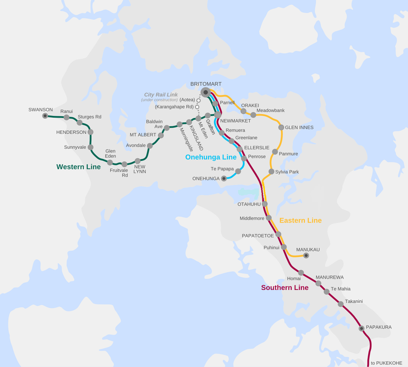
Geographic map
Network
| ||||||
| Distance from Britomart | Name | Served by | Opened | Closed | Notes | |
|---|---|---|---|---|---|---|
| 0.00 km (0.00 mi) | BritomartH | Auckland Transport | 7 July 2003[1] | – | ||
| 1.2 km (0.75 mi) | Auckland | Northern Explorer, private excursions and charters | 24 November 1930[1] | 7 July 2003[1] | After the opening of Britomart, one platform remained open for excursion trains and thereafter referred to as The Strand station. The Strand upgraded in 2011 with two platforms as a back up station for Britomart. The Northern Explorer terminus was relocated here in December 2015. | |
| Parnell | Auckland Transport | 12 March 2017 | – | |||
| 3.84 km (2.39 mi) | NewmarketH | Auckland Transport | 20 December 1873[1] | – | ||
| 4.91 km (3.05 mi) | Remuera | Auckland Transport | 20 December 1873[1] | – | ||
| 6.38 km (3.96 mi) | Greenlane | Auckland Transport | 20 December 1873[1] | – | ||
| 7.75 km (4.82 mi) | Ellerslie | Auckland Transport | 20 December 1873[1] | – | ||
| 9.2 km (5.72 mi) | Penrose | Auckland Transport | 24 December 1873[1] | – | ||
| 11.09 km (6.89 mi) | Southdown | N/A | 8 August 1905[1] | 30 May 2004[1] | ||
| 13.01 km (8.08 mi) | Westfield | N/A | 29 August 1887[1] | 12 March 2017[2] | ||
| 14.33 km (8.90 mi) | OtahuhuH | Auckland Transport | 20 May 1875[1] | – | New station and bus-train interchange opened October 2016.[3] | |
| 15.46 km (9.61 mi) | Mangere | N/A | c. July 1908[1] | 9 December 2011 | Services reduced to set-down of school students at the southbound platform only from 25 October 2005.[1] Southbound platform closed on 9 December 2011. Both northbound and southbound platforms demolished 2012. | |
| 16.2 km (10.07 mi) | Middlemore | Auckland Transport | 20 July 1947[1] | – | ||
| 18.06 km (11.22 mi) | Papatoetoe | Auckland Transport | 20 May 1875[1] | – | ||
| 19.56 km (12.15 mi) | Puhinui | Auckland Transport | 29 June 1925[1] | – | ||
| 20.88 km (12.97 mi) | Wiri Depot | Auckland Transport | 9 December 1913[1] | Closed in 2005. Rebuilt in 2013. | Staff station only. | |
| 22.78 km (14.15 mi) | Homai | Auckland Transport | 15 August 1924[1] | – | ||
| 24.41 km (15.17 mi) | ManurewaH | Auckland Transport | 20 May 1875[1] | – | Opened at a new site on 19 July 1993.[1] | |
| 26.24 km (16.30 mi) | Te Mahia | Auckland Transport | 16 August 1926[1] | – | ||
| 27.84 km (17.30 mi) | Takanini | Auckland Transport | 9 December 1913[1] | – | ||
| 29.53 km (18.35 mi) | Tironui | N/A | 10 May 1926[1] | 13 August 1983[1] | New station currently (2012) proposed just north of former Tironui station at Walters Road by Papakura Local Board. | |
| 31.46 km (19.55 mi) | PapakuraH | Auckland Transport | 20 May 1875[1] | – | The terminus for electric unit services (see note for Pukekohe below). Current station rebuilt and reopened in 2013. | |
| 33.75 km (20.97 mi) | Opaheke | N/A | c. April 1884[1] | 13 November 1955[1] | ||
| 36.57 km (22.72 mi) | Drury | N/A | 20 May 1875[1] | 21 May 1972[1] | Opened at a new site on 8 December 1918 replacing the original station and another station at Runciman.[1] New station at Drury currently (2012) proposed by Papakura Local Board. | |
| 45.19 km (28.08 mi) | Paerata | N/A | 20 May 1875[1] | 24 July 1972[1] | ||
| 49.62 km (30.83 mi) | PukekoheH | Auckland Transport | 20 May 1875[1] | – | From 20 July 2015, a diesel train shuttle service operates between Papakura and Pukekohe, necessitating a transfer by passengers at Papakura, as that section of line has not been electrified. In 2016 construction began on a new station and bus-train interchange. The new station is currently scheduled to open during 2018.[4][5] | |
H Major transport hub station. | ||||||
| ||||||
| Distance from Britomart | Name | Served by | Opened | Closed | Notes | |
|---|---|---|---|---|---|---|
| 0.00 km (0.00 mi) | BritomartH | Auckland Transport | 7 July 2003[1] | – | ||
| 1.2 km (0.75 mi) | Auckland | Northern Explorer, private excursions and charters | 24 November 1930[1] | 7 July 2003[1] | After the opening of Britomart, one platform remained open for excursion trains and thereafter referred to as The Strand station. The Strand upgraded in 2011 with two platforms as a back up station for Britomart. The Northern Explorer terminus was relocated here in December 2015. | |
| 4.62 km (2.87 mi) | Orakei | Auckland Transport | 16 November 1930[1] | – | ||
| 5.8 km (3.60 mi) | Meadowbank | Auckland Transport | 21 July 1947[1] | – | Replaced the original Purewa station but was also known as Purewa until 22 February 1954.[1] | |
| 6.6 km (4.10 mi) | Purewa | N/A | 1930[6] | 16 April 1947[1] | ||
| 9.42 km (5.85 mi) | Glen Innes | Auckland Transport | 6 May 1930[1] | – | ||
| 10.78 km (6.70 mi) | Tamaki | N/A | 16 November 1930[1] | 13 October 2003[1][7] | ||
| 12.13 km (7.54 mi) | PanmureH | Auckland Transport | 16 November 1930[1] | – | An upgraded station was opened in the first half of 2007.[8] | |
| 14.97 km (9.30 mi) | Sylvia Park | Auckland Transport | 1 September 1929[1] | – | Original station closed on 6 March 1983.[1] A new station opened on 2 July 2007 at a different site.[9] | |
| 16.59 km (10.31 mi) | Westfield | N/A | 29 August 1887[1] | 12 March 2017[10] | ||
OtahuhuH | Auckland Transport | 20 May 1875[1] | – | New station and bus-train interchange opened October 2016.[3] | ||
| Mangere | N/A | c. July 1908[1] | 9 December 2011 | Services reduced to set-down of school students at the southbound platform only from 25 October 2005.[1] Southbound platform closed on 9 December 2011. Both northbound and southbound platforms demolished 2012. | ||
| Middlemore | Auckland Transport | 20 July 1947[1] | – | |||
| Papatoetoe | Auckland Transport | 20 May 1875[1] | – | |||
| Puhinui | Auckland Transport | 29 June 1925[1] | – | |||
| 23 km (14.29 mi) | ManukauH | Auckland Transport | 15 April 2012[11] | – | A bus interchange adjacent to the station was opened in April 2018.[12] | |
H Major transport hub station. | ||||||
| ||||||
| Distance from Britomart | Name | Served by | Opened | Closed | Notes | |
|---|---|---|---|---|---|---|
| 0.00 km (0.00 mi) | BritomartH | Auckland Transport | 7 July 2003[1] | – | ||
| 1.2 km (0.75 mi) | Auckland | Northern Explorer, private excursions and charters | 24 November 1930[1] | 7 July 2003[1] | After the opening of Britomart, one platform remained open for excursion trains and thereafter referred to as The Strand station. The Strand upgraded in 2011 with two platforms as a back up station for Britomart. The Northern Explorer terminus was relocated here in December 2015. | |
| Parnell | Auckland Transport | 12 March 2017 | – | Onehunga Line services do not stop at this station. | ||
| 3.84 km (2.39 mi) | NewmarketH | Auckland Transport | 20 December 1873[1] | – | ||
| 4.91 km (3.05 mi) | Remuera | Auckland Transport | 20 December 1873[1] | – | Effective from 26 August 2018, Onehunga Line services stop at this station in evenings only. | |
| 6.38 km (3.96 mi) | Greenlane | Auckland Transport | 20 December 1873[1] | – | Effective from 26 August 2018, Onehunga Line services stop at this station in evenings only. | |
| 6.79 km (4.22 mi) | Ellerslie Racecourse Platform | N/A | c. April 1884[1] | 1973 | ||
| 7.75 km (4.82 mi) | Ellerslie | Auckland Transport | 20 December 1873[1] | – | ||
| 9.2 km (5.72 mi) | Penrose | Auckland Transport | 24 December 1873[1] | – | ||
| 11.15 km (6.93 mi) | Te Papapa | Auckland Transport | 8 April 1877[1] | – | Closed on 19 February 1973[1] and reopened on 18 September 2010.[13] Services recommenced on 19 September 2010.[13] | |
| 12.52 km (7.78 mi) | Onehunga | Auckland Transport | 20 December 1873[1] | – | Closed on 19 February 1973[1] and reopened on 18 September 2010.[13] Services recommenced on 19 September 2010.[13] | |
| 12.61 km (7.84 mi) | Onehunga Wharf | N/A | c. April 1892[1] | 1927[14] | ||
H Major transport hub station. | ||||||
| ||||||
| Distance from Britomart | Name | Served by | Opened | Closed | Notes | |
|---|---|---|---|---|---|---|
| 0.00 km (0.00 mi) | BritomartH | Auckland Transport | 7 July 2003[1] | – | ||
| 1.2 km (0.75 mi) | Auckland | Northern Explorer, private excursions and charters | 24 November 1930[1] | 7 July 2003[1] | After the opening of Britomart, one platform remained open for excursion trains and thereafter referred to as The Strand station. The Strand upgraded in 2011 with two platforms as a back up station for Britomart. The Northern Explorer terminus was relocated here in December 2015. | |
| Parnell | Auckland Transport | 12 March 2017 | – | Services initially stopped at this station in weekday evenings and at weekends only. From 26 August 2018, it became a stop for all services. | ||
| 3.84 km (2.39 mi) | NewmarketH | Auckland Transport | 20 December 1873[1] | – | ||
| Grafton | Auckland Transport | 9 April 2010[15] | – | Replaced the nearby Boston Rd Station. | ||
| Boston Road | N/A | 15 September 1964 | 10 April 2010[15] | |||
| 6.44 km (4.00 mi) | Mount Eden | Auckland Transport | 29 March 1880[1] | – | ||
| 7.79 km (4.84 mi) | Kingsland | Auckland Transport | 29 March 1880[1] | – | ||
| 8.76 km (5.44 mi) | Morningside | Auckland Transport | c. April 1882[1] | – | ||
| 10.09 km (6.27 mi) | Baldwin Avenue | Auckland Transport | 28 September 1953[1] | – | ||
| 11.12 km (6.91 mi) | Mount Albert | Auckland Transport | 29 March 1880[1] | – | Platform rebuilt and upgraded and pedestrian walkways opened in 2-stage program 2012-2016.[16][17] | |
| 12.83 km (7.97 mi) | Avondale | Auckland Transport | 29 March 1880[1] | – | Original station replaced with a temporary facility on 19 January 2009 pending completion of new station.[1] Reopened on 8 June 2010.[18] | |
| St George's Street | N/A | November 1907[1] | 18 August 1980[19] | Closed on a six-month trial basis that was made permanent on 16 August 1981.[1] | ||
| 15.55 km (9.66 mi) | New LynnH | Auckland Transport | 29 March 1880[1] | – | Original station closed on 28 June 1986. New station opened in 1984 and replaced with temporary facility on 4 May 2009 pending completion of trench.[1] Current station opened on 24 Sep 2010.[20] | |
| 16.66 km (10.35 mi) | Fruitvale Road | Auckland Transport | 28 September 1953[1] | – | ||
| 17.63 km (10.95 mi) | Croydon Road | N/A | c. December 1911[1] | 18 August 1980[19] | Closed on a six-month trial basis that was made permanent on 16 August 1981.[1] | |
| 18.46 km (11.47 mi) | Glen Eden | Auckland Transport | 29 March 1880[1] | – | ||
| 19.64 km (12.20 mi) | Westbrook | N/A | 6 September 1957[1] | 18 August 1980[19] | Closed on a six-month trial basis that was made permanent on 16 August 1981.[1] | |
| ? | Waikomiti | N/A | c. 1880 | ? | Only used for cemetery services.[21] | |
| 20.77 km (12.91 mi) | Sunnyvale | Auckland Transport | 28 February 1924[1] | – | ||
| 22.39 km (13.91 mi) | HendersonH | Auckland Transport | 21 December 1880[1] | – | Rebuilt on 24 October 2006. Reopened on 2 November 2006. | |
| 23.86 km (14.83 mi) | Sturges Road | Auckland Transport | 1934[1] | – | ||
| 25.71 km (15.98 mi) | Ranui | Auckland Transport | 16 November 1925[1] | – | ||
| 28 km (17.40 mi) | Swanson | Auckland Transport | 18 July 1881[1] | – | Terminus for electric unit services. Platform replaced in 2000.[1] | |
| 31.93 km (19.84 mi) | Waitakere | N/A | 18 July 1881[1] | 20 July 2015 | Hourly bus shuttles operate between Swanson station and Waitakere station as that section of line has not been electrified.[22] | |
| Helensville | N/A | 18 July 1881[1] | 12 June 1987 | Services were extended to Helensville station for a trial period from 2008–09. | ||
H Major transport hub station. | ||||||
New stations
Aotea Station and Karangahape Station, underground stations in the City Centre, will open when the City Rail Link is completed in 2023.
New stations at Tironui, Drury, Drury West and Paerata are proposed to be built within the next few decades to serve new urban areas developing in the south of the city.
See also
- List of suburban and commuter rail systems
- City Rail Link
References
^ abcdefghijklmnopqrstuvwxyzaaabacadaeafagahaiajakalamanaoapaqarasatauavawaxayazbabbbcbdbebfbgbhbibjbkblbmbnbobpbqbrbsbtbubvbwbxbybzcacbcccdcecfcgchcicjckclcmcncocpcqcrcs Scoble, Juliet (2010). "Names & Opening & Closing Dates of Railway Stations" (PDF). Rail Heritage Trust of New Zealand. Retrieved 11 November 2018..mw-parser-output cite.citationfont-style:inherit.mw-parser-output .citation qquotes:"""""""'""'".mw-parser-output .citation .cs1-lock-free abackground:url("//upload.wikimedia.org/wikipedia/commons/thumb/6/65/Lock-green.svg/9px-Lock-green.svg.png")no-repeat;background-position:right .1em center.mw-parser-output .citation .cs1-lock-limited a,.mw-parser-output .citation .cs1-lock-registration abackground:url("//upload.wikimedia.org/wikipedia/commons/thumb/d/d6/Lock-gray-alt-2.svg/9px-Lock-gray-alt-2.svg.png")no-repeat;background-position:right .1em center.mw-parser-output .citation .cs1-lock-subscription abackground:url("//upload.wikimedia.org/wikipedia/commons/thumb/a/aa/Lock-red-alt-2.svg/9px-Lock-red-alt-2.svg.png")no-repeat;background-position:right .1em center.mw-parser-output .cs1-subscription,.mw-parser-output .cs1-registrationcolor:#555.mw-parser-output .cs1-subscription span,.mw-parser-output .cs1-registration spanborder-bottom:1px dotted;cursor:help.mw-parser-output .cs1-ws-icon abackground:url("//upload.wikimedia.org/wikipedia/commons/thumb/4/4c/Wikisource-logo.svg/12px-Wikisource-logo.svg.png")no-repeat;background-position:right .1em center.mw-parser-output code.cs1-codecolor:inherit;background:inherit;border:inherit;padding:inherit.mw-parser-output .cs1-hidden-errordisplay:none;font-size:100%.mw-parser-output .cs1-visible-errorfont-size:100%.mw-parser-output .cs1-maintdisplay:none;color:#33aa33;margin-left:0.3em.mw-parser-output .cs1-subscription,.mw-parser-output .cs1-registration,.mw-parser-output .cs1-formatfont-size:95%.mw-parser-output .cs1-kern-left,.mw-parser-output .cs1-kern-wl-leftpadding-left:0.2em.mw-parser-output .cs1-kern-right,.mw-parser-output .cs1-kern-wl-rightpadding-right:0.2em
^ "Auckland Transport to close Westfield train station". NZ Herald. 17 January 2017. Retrieved 28 February 2017.
^ ab "New Otahuhu Station and a New Network for South Auckland". Auckland Transport. Retrieved 25 October 2016.
^ "Pukekohe upgrade improves connections". Auckland Transport. 5 October 2015. Retrieved 7 October 2015.
^ "Pukekohe Station project updates". Auckland Transport. Retrieved 18 March 2018.
^ "Westfield Deviation – One track in use by May". The New Zealand Herald. 27 February 1929. Retrieved 27 February 2019.
^ WATKIN, TIM (4 October 2003). "Demand forces rail-rescue plans". The New Zealand Herald. Auckland: APN Holdings NZ. Retrieved 28 January 2012.
^ Dearnaley, Mathew (20 November 2006). "More trains at off-peak times". The New Zealand Herald. Auckland: APN Holdings NZ. Retrieved 28 January 2012.
^ Dearnaley, Mathew (2 July 2007). "Next stop, shopping ... big centre gets its own rail station". The New Zealand Herald. Auckland: APN Holdings NZ. Retrieved 28 January 2012.
^ "Auckland Transport to close Westfield train station". NZ Herald. 17 January 2017. Retrieved 28 February 2017.
^ "Manukau Station Stage 1 Opening". MAXX. Archived from the original on 11 April 2012.
^ "Manukau's new bus station opens". Auckland Transport. Retrieved 5 April 2018.
^ abcd Powley, Kathryn; Emma Geraghty (19 September 2010). "People turn out to show car not the only way to travel". The New Zealand Herald. Auckland: APN Holdings NZ. Retrieved 28 January 2012.
^ Bromby, Robin (2003). "Branch Lines – North Island". In Olphert, Lorraine. Rails That Built A Nation: An Encyclopedia of New Zealand Railways. Wellington: Grantham House Publishing. p. 58. ISBN 1-86934-080-9.
^ ab Dearnaley, Mathew (9 April 2010). "Enter the station here, here, here ... or here". The New Zealand Herald. Auckland: APN Holdings NZ. Retrieved 28 January 2012.
^ "Mt Albert station". Auckland Transport. Retrieved 7 October 2015.
^ "Stage one transforms Mt Albert Train Station". Scoop.co.nz. 4 July 2013. Retrieved 3 February 2017.
^ Dearnaley, Mathew (9 June 2010). "New station comes with safety message". The New Zealand Herald. Auckland: APN Holdings NZ. Retrieved 28 January 2012.
^ abc Western Leader, 26 August 1980, front page.
^ Dearnaley, Mathew (25 September 2010). "Governor General slams Auckland's traffic congestion". The New Zealand Herald. Auckland: APN Holdings NZ. Retrieved 28 January 2012.
^ "Web Archive". Wayback Machine. 9 April 2017. Archived from the original on 9 April 2017.CS1 maint: BOT: original-url status unknown (link)
^ "Rail service between Swanson and Waitakere to be scrapped". NewstalkZB. 1 June 2013.


