Cabinet Mountains
| Cabinet Mountains | |
|---|---|
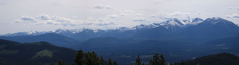
 Snowshoe Peak, highest point in the Cabinet Mountains | |
| Highest point | |
| Peak | Snowshoe Peak |
| Elevation | 8,738 ft (2,663 m) [1] |
| Coordinates | 48°13′N 115°41′W / 48.217°N 115.683°W / 48.217; -115.683Coordinates: 48°13′N 115°41′W / 48.217°N 115.683°W / 48.217; -115.683 |
| Dimensions | |
| Area | 2,134 sq mi (5,530 km2) [1] |
| Geography | |
| Country | United States |
| States | Idaho and Montana |
| Parent range | Rocky Mountains |
The Cabinet Mountains are part of the Rocky Mountains, located in northwest Montana and the Idaho panhandle, in the United States. The mountains cover an area of 2,134 square miles (5,527 km²). The Cabinet Mountains lie south of the Purcell Mountains, between the Kootenai River and Clark Fork River and Idaho's Lake Pend Oreille. The Cabinet Mountains lie to the east of the Purcell Trench. The Cabinet Mountains form the north side of the Clark Fork River valley in Idaho and Montana. The Cabinet Mountains Wilderness is located east of the Bull River near Noxon, Montana in roughly the center of the range.
The highest peaks are Snowshoe Peak (8,738 ft, 2,663 m),[2]A Peak (8,634 ft, 2,632 m),[2]Bockman Peak (8,174 ft, 2,491 m),[2] and Elephant Peak (7,938 ft, 2,433 m).[2] Although of lower altitude than many Rocky Mountain peaks to the east in Montana, the Cabinet Mountains offer a stark contrast as the surrounding river valleys are at such relative low altitude.
The Cabinets are noted, along with the nearby Selkirk Mountains to the west, as being some of the most "wild" mountains left in the contiguous United States. They are home to mule deer, elk, moose, bighorn sheep, black bear, grizzly bear, wolverine, wolves and many smaller species.[3]
The Cabinet Mountain geology is also believed to be potentially rich in minerals.[4][5]
See also
- List of mountain ranges in Montana
Notes
^ ab "Cabinet Mountains". Peakbagger.com..mw-parser-output cite.citationfont-style:inherit.mw-parser-output .citation qquotes:"""""""'""'".mw-parser-output .citation .cs1-lock-free abackground:url("//upload.wikimedia.org/wikipedia/commons/thumb/6/65/Lock-green.svg/9px-Lock-green.svg.png")no-repeat;background-position:right .1em center.mw-parser-output .citation .cs1-lock-limited a,.mw-parser-output .citation .cs1-lock-registration abackground:url("//upload.wikimedia.org/wikipedia/commons/thumb/d/d6/Lock-gray-alt-2.svg/9px-Lock-gray-alt-2.svg.png")no-repeat;background-position:right .1em center.mw-parser-output .citation .cs1-lock-subscription abackground:url("//upload.wikimedia.org/wikipedia/commons/thumb/a/aa/Lock-red-alt-2.svg/9px-Lock-red-alt-2.svg.png")no-repeat;background-position:right .1em center.mw-parser-output .cs1-subscription,.mw-parser-output .cs1-registrationcolor:#555.mw-parser-output .cs1-subscription span,.mw-parser-output .cs1-registration spanborder-bottom:1px dotted;cursor:help.mw-parser-output .cs1-ws-icon abackground:url("//upload.wikimedia.org/wikipedia/commons/thumb/4/4c/Wikisource-logo.svg/12px-Wikisource-logo.svg.png")no-repeat;background-position:right .1em center.mw-parser-output code.cs1-codecolor:inherit;background:inherit;border:inherit;padding:inherit.mw-parser-output .cs1-hidden-errordisplay:none;font-size:100%.mw-parser-output .cs1-visible-errorfont-size:100%.mw-parser-output .cs1-maintdisplay:none;color:#33aa33;margin-left:0.3em.mw-parser-output .cs1-subscription,.mw-parser-output .cs1-registration,.mw-parser-output .cs1-formatfont-size:95%.mw-parser-output .cs1-kern-left,.mw-parser-output .cs1-kern-wl-leftpadding-left:0.2em.mw-parser-output .cs1-kern-right,.mw-parser-output .cs1-kern-wl-rightpadding-right:0.2em, Peakbagger.com
^ abcd United States Forest Service. Kootenai and East Half Kaniksu National Forests[map]. 1:126,720. United States Forest Service, 2004.
^ "Cabinet Mountains Wilderness". Montana Office of Tourism. Archived from the original on 2002-11-09. Retrieved 2009-08-22.
^ https://pubs.er.usgs.gov/#search:basic/query=Cabinet%20Mountains/page=1/page_size=100:0
^ Mineral resources of the Cabinet Mountains Wilderness, Lincoln and Sanders counties, Montana
1981, U. S. Geological Survey; U. S. Bureau of Mines.
USGS Bulletin: 1501
Helena (capital) | ||
| Topics |
|  Seal of Montana |
| Society |
| |
| Regions |
| |
| Largest cities |
| |
| Counties |
| |
Boise (capital) | ||
| Topics |
|  Seal of Idaho |
| Society |
| |
| Regions |
| |
| Larger cities |
| |
| Smaller cities |
| |
| Counties |
| |
This Idaho location article is a stub. You can help Wikipedia by expanding it. |
This Montana state location article is a stub. You can help Wikipedia by expanding it. |


