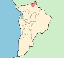
Town of Gawler
Town of Gawler South Australia | |||||||||||||||
|---|---|---|---|---|---|---|---|---|---|---|---|---|---|---|---|
 | |||||||||||||||
| Population | 23,034 (2016 census)[1] | ||||||||||||||
| • Density | 560.438560.4/km2 (1,451.5281,451.5/sq mi) | ||||||||||||||
| Established | 1857 | ||||||||||||||
| Area | 41.1 km2 (15.9 sq mi) | ||||||||||||||
| Mayor | Karen Redman[citation needed] | ||||||||||||||
| Council seat | Gawler | ||||||||||||||
| Region | Barossa, Light and Lower North[2] | ||||||||||||||
| State electorate(s) | Light | ||||||||||||||
| Federal Division(s) | Wakefield | ||||||||||||||
 | |||||||||||||||
| Website | Town of Gawler | ||||||||||||||
| |||||||||||||||
The Town of Gawler is a local government area located north of Adelaide city centre in South Australia containing Gawler and its suburbs. The corporate town was established in 1857 due to the township's residents' dissatisfaction at being governed by three different district councils.
The Town of Gawler is located within the officially declared boundaries of the Adelaide metropolitan area.[3] As of 2001[update] 1.0% of the population were Indigenous Australian, and 76.3% were born in Australia.
The current mayor of Gawler is Karen Redman (elected November 2014), the first female mayor in the town's history.[citation needed]
Contents
1 History
2 Council
3 Suburbs
4 Waste management and recycling
5 See also
6 References
7 External links
History
Local government was established in the area from 1853 with the creation of the District Council of Barossa West (covering the western half of the Hundred of Barossa). Residents of the township of Gawler, at the confluence of the North and South Para rivers, were dissatisfied with the state of local governance. The township intersects four separate cadastral divisions, being at the corners of the hundreds of Mudla Wirra, Nuriootpa, Barossa and Munno Para. As such, the east half of the township was locally governed by the Barossa West council, the western half by the District Council of Mudla Wirra and the southern outskirts by the District Council of Munno Para West. The Barossa West council was seated at Lyndoch some 13 kilometres (8.1 mi) east of the township. The Gawler ratepayers petitioned for their own local government, centred in Gawler, and the Corporation of the Town of Gawler was established on 9 July 1857.
Council
The current council as of November 2018[update] is:[4]
| Ward | Councillor | Notes |
|---|---|---|
| Mayor | Karen Redman | |
| Unsubdivided | Cody Davies | |
| Diane Fraser | ||
| Kelvin Goldstone | ||
| David Hughes | ||
| Paul Koch | ||
| Paul Little | ||
| Brian Sambell | ||
| Nathan Shanks | ||
| Ian Tooley | ||
| Jim Vallelonga |
Suburbs
Bibaringa (5118) (part; shared with City of Playford)
Evanston (5116)
Evanston Gardens (5116)
Evanston Park (5116) (part; shared with City of Playford)
Evanston South (5116)
Gawler (5118)
Gawler East (5118)
Gawler South (5118)
Gawler West (5118)
Hillier (5116) (part; shared with City of Playford)
Kudla (5115)
Reid (5118) (part; shared with Light Regional Council)
Willaston (5118)
Waste management and recycling
Garbage, recycling, and green waste collection services are provided by the Northern Adelaide Waste Management Authority.
See also
- Gawler, South Australia
- List of Adelaide suburbs
- Local Government Areas of South Australia
References
^ Australian Bureau of Statistics (27 June 2017). "Gawler (T)". 2016 Census QuickStats. Retrieved 29 November 2017..mw-parser-output cite.citationfont-style:inherit.mw-parser-output .citation qquotes:"""""""'""'".mw-parser-output .citation .cs1-lock-free abackground:url("//upload.wikimedia.org/wikipedia/commons/thumb/6/65/Lock-green.svg/9px-Lock-green.svg.png")no-repeat;background-position:right .1em center.mw-parser-output .citation .cs1-lock-limited a,.mw-parser-output .citation .cs1-lock-registration abackground:url("//upload.wikimedia.org/wikipedia/commons/thumb/d/d6/Lock-gray-alt-2.svg/9px-Lock-gray-alt-2.svg.png")no-repeat;background-position:right .1em center.mw-parser-output .citation .cs1-lock-subscription abackground:url("//upload.wikimedia.org/wikipedia/commons/thumb/a/aa/Lock-red-alt-2.svg/9px-Lock-red-alt-2.svg.png")no-repeat;background-position:right .1em center.mw-parser-output .cs1-subscription,.mw-parser-output .cs1-registrationcolor:#555.mw-parser-output .cs1-subscription span,.mw-parser-output .cs1-registration spanborder-bottom:1px dotted;cursor:help.mw-parser-output .cs1-ws-icon abackground:url("//upload.wikimedia.org/wikipedia/commons/thumb/4/4c/Wikisource-logo.svg/12px-Wikisource-logo.svg.png")no-repeat;background-position:right .1em center.mw-parser-output code.cs1-codecolor:inherit;background:inherit;border:inherit;padding:inherit.mw-parser-output .cs1-hidden-errordisplay:none;font-size:100%.mw-parser-output .cs1-visible-errorfont-size:100%.mw-parser-output .cs1-maintdisplay:none;color:#33aa33;margin-left:0.3em.mw-parser-output .cs1-subscription,.mw-parser-output .cs1-registration,.mw-parser-output .cs1-formatfont-size:95%.mw-parser-output .cs1-kern-left,.mw-parser-output .cs1-kern-wl-leftpadding-left:0.2em.mw-parser-output .cs1-kern-right,.mw-parser-output .cs1-kern-wl-rightpadding-right:0.2em
^ "Barossa, Light and Lower North" (PDF). Department of Planning, Transport and Infrastructure. Retrieved 24 June 2015.
^ "Adelaide metropolitan boundary (as declared on 11 November 1993)" (PDF). Government of South Australia. Retrieved 24 June 2015.
^ "Council Members". Town of Gawler. Town of Gawler. Retrieved 24 February 2019.
External links
- Official site
- Town of Gawler's first 50 years
Coordinates: 34°36′S 138°45′E / 34.600°S 138.750°E / -34.600; 138.750
This Australian government-related article is a stub. You can help Wikipedia by expanding it. |
This article about a place in Adelaide is a stub. You can help Wikipedia by expanding it. |
