Barossa Council
Barossa District Council South Australia | |||||||||||||||
|---|---|---|---|---|---|---|---|---|---|---|---|---|---|---|---|
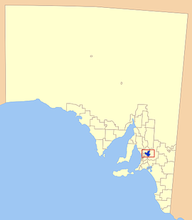
 Location of the Barossa Council in blue | |||||||||||||||
| Population | 23,558 (2016 census)[1] | ||||||||||||||
| • Density | 25.8311425.831/km2 (66.902366.90/sq mi) | ||||||||||||||
| Established | 1996 | ||||||||||||||
| Area | 912 km2 (352.1 sq mi) | ||||||||||||||
| Mayor | Bob Sloane [2] | ||||||||||||||
| Council seat | Nuriootpa | ||||||||||||||
| Region | Barossa Light and Lower North[3] | ||||||||||||||
| State electorate(s) | Schubert | ||||||||||||||
| Federal Division(s) | Wakefield | ||||||||||||||
 | |||||||||||||||
| Website | Barossa District Council | ||||||||||||||
| |||||||||||||||
Barossa Council is a local government area in the Barossa Valley in South Australia. The council area covers 912 square kilometres and had a population of over 23,000 as at the 2016 Census.
Contents
1 History
2 Description
3 Mayors
4 See also
5 References
6 External links
History
It was proclaimed on 1 July 1996 following the amalgamation of the District Council of Angaston, the District Council of Barossa and the District Council of Tanunda. It also gained a portion of the former District Council of Mount Pleasant on 1 July 1997.[4]
Description
Townships in the council area include
- Angaston
- Eden Valley
- Lyndoch
- Moculta
- Mount Pleasant
- Nuriootpa
- Penrice
- Springton
- Stockwell
- Tanunda
- Williamstown
Mayors
Brian Hurn - 1996-2014- Bob Sloane - 2014-2018
- Michael "Bim" Lange - 2018 - present
See also
- List of parks and gardens in rural South Australia
- Hoffnungsthal, South Australia
References
^ Australian Bureau of Statistics (27 June 2017). "Barossa (DC)". 2016 Census QuickStats. Retrieved 29 November 2017..mw-parser-output cite.citationfont-style:inherit.mw-parser-output .citation qquotes:"""""""'""'".mw-parser-output .citation .cs1-lock-free abackground:url("//upload.wikimedia.org/wikipedia/commons/thumb/6/65/Lock-green.svg/9px-Lock-green.svg.png")no-repeat;background-position:right .1em center.mw-parser-output .citation .cs1-lock-limited a,.mw-parser-output .citation .cs1-lock-registration abackground:url("//upload.wikimedia.org/wikipedia/commons/thumb/d/d6/Lock-gray-alt-2.svg/9px-Lock-gray-alt-2.svg.png")no-repeat;background-position:right .1em center.mw-parser-output .citation .cs1-lock-subscription abackground:url("//upload.wikimedia.org/wikipedia/commons/thumb/a/aa/Lock-red-alt-2.svg/9px-Lock-red-alt-2.svg.png")no-repeat;background-position:right .1em center.mw-parser-output .cs1-subscription,.mw-parser-output .cs1-registrationcolor:#555.mw-parser-output .cs1-subscription span,.mw-parser-output .cs1-registration spanborder-bottom:1px dotted;cursor:help.mw-parser-output .cs1-ws-icon abackground:url("//upload.wikimedia.org/wikipedia/commons/thumb/4/4c/Wikisource-logo.svg/12px-Wikisource-logo.svg.png")no-repeat;background-position:right .1em center.mw-parser-output code.cs1-codecolor:inherit;background:inherit;border:inherit;padding:inherit.mw-parser-output .cs1-hidden-errordisplay:none;font-size:100%.mw-parser-output .cs1-visible-errorfont-size:100%.mw-parser-output .cs1-maintdisplay:none;color:#33aa33;margin-left:0.3em.mw-parser-output .cs1-subscription,.mw-parser-output .cs1-registration,.mw-parser-output .cs1-formatfont-size:95%.mw-parser-output .cs1-kern-left,.mw-parser-output .cs1-kern-wl-leftpadding-left:0.2em.mw-parser-output .cs1-kern-right,.mw-parser-output .cs1-kern-wl-rightpadding-right:0.2em
^ "Your Elected Members". Barossa Council. Retrieved 9 April 2016.
^ "Barossa, Light and Lower North SA Government region" (PDF). The Government of South Australia. Retrieved 10 October 2014.
^ "About Council Fact Sheet" (PDF). Barossa Council. Retrieved 31 March 2016.
External links
- Official website
- Local Government Association
Coordinates: 34°30′S 139°03′E / 34.500°S 139.050°E / -34.500; 139.050
This Australian government-related article is a stub. You can help Wikipedia by expanding it. |
