Tillamook State Forest
| Tillamook State Forest | |
|---|---|
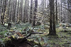 Tillamook State Forest, February 2010 | |
| Type | Public, state |
| Location | Oregon, United States |
| Coordinates | 45°32′21″N 123°17′20″W / 45.539278°N 123.289001°W / 45.539278; -123.289001Coordinates: 45°32′21″N 123°17′20″W / 45.539278°N 123.289001°W / 45.539278; -123.289001 |
| Area | 364,000 acres (1,470 km2) |
| Created | 1973 |
| Operated by | Oregon Department of Forestry |
The Tillamook State Forest is a 364,000-acre (1,470 km2) publicly owned forest in the U.S. state of Oregon. Managed by the Oregon Department of Forestry, it is located 40 miles (64 km) west of Portland in the Northern Oregon Coast Range, and spans Washington, Tillamook, Yamhill, and Clatsop counties. The forest receives large amounts of precipitation and is dominated by Douglas-fir trees. Activities include commercial logging, recreation, and other commercial resource extraction activities such as mushroom hunting.
Contents
1 History
2 Operations
3 Tillamook Rainforest
4 See also
5 References
6 External links
History
The area was extensively burned in a series of forest fires starting in 1933 which are now called the Tillamook Burn. The forest was replanted from 1949 to 1973 in the largest reforestation project of its kind. On July 18, 1973, Oregon governor Tom McCall officially designated it a State Forest.
Operations

Tillamook Forest Center
The forest's recreation sites include campgrounds, hiking and backpacking trails, fishing, swimming and an interpretative center. Some of the trails are open to horses and pack animals, mountain bikes and motorized vehicles in various combinations. In 2006, the Tillamook Forest Center opened on Oregon Route 6 between Portland and Tillamook. The Forest Center's features include a short film about the Tillamook Burn,[1] and a suspension bridge crossing the Wilson River. With exhibits designed by AldrichPears Associates and architecture by MillerHull Partnership, the Center won the Oregon Tourism Achievement Award in 2007.[2]
Commercial activities include timber harvesting managed by the Department of Forestry that benefits county governments.[3] In addition to logging, other commercial activities include mushroom hunting, and moss and salal harvesting.[4] The forest is managed by the department's Forest Grove and Tillamook districts.[4]

Tillamook state forest - logging area
Tillamook Rainforest
The Tillamook Rainforest is a temperate rainforest located in the Coast Range of northwestern Oregon, United States, between Hillsboro and Tillamook in Washington and Tillamook counties. Part of the forest is administered as part of the Tillamook State Forest.
The Tillamook Rainforest is one of the wettest areas of the United States, with parts getting more than 100 inches (2,500 mm) of rain.[citation needed] The higher elevations also receive a lot of snow.[5]
The western part of the forest has coastal varieties of trees, while the east is dominated by Douglas-fir. Much of the forest is young, as early deforestation was rampant[citation needed] and the Tillamook Burn, a large wildfire, passed through the area in 1933.[6]
See also
- List of Oregon state forests
- South Saddle Mountain
- Rogers Peak
- Ki-a-Kuts Falls
References
^ Via Magazine
^ Oregon Department of Forestry
^ Profita, Cassandra (September 5, 2008). "Forest leaders challenge notions about logging". The Daily Astorian. Retrieved 2008-12-15..mw-parser-output cite.citationfont-style:inherit.mw-parser-output .citation qquotes:"""""""'""'".mw-parser-output .citation .cs1-lock-free abackground:url("//upload.wikimedia.org/wikipedia/commons/thumb/6/65/Lock-green.svg/9px-Lock-green.svg.png")no-repeat;background-position:right .1em center.mw-parser-output .citation .cs1-lock-limited a,.mw-parser-output .citation .cs1-lock-registration abackground:url("//upload.wikimedia.org/wikipedia/commons/thumb/d/d6/Lock-gray-alt-2.svg/9px-Lock-gray-alt-2.svg.png")no-repeat;background-position:right .1em center.mw-parser-output .citation .cs1-lock-subscription abackground:url("//upload.wikimedia.org/wikipedia/commons/thumb/a/aa/Lock-red-alt-2.svg/9px-Lock-red-alt-2.svg.png")no-repeat;background-position:right .1em center.mw-parser-output .cs1-subscription,.mw-parser-output .cs1-registrationcolor:#555.mw-parser-output .cs1-subscription span,.mw-parser-output .cs1-registration spanborder-bottom:1px dotted;cursor:help.mw-parser-output .cs1-ws-icon abackground:url("//upload.wikimedia.org/wikipedia/commons/thumb/4/4c/Wikisource-logo.svg/12px-Wikisource-logo.svg.png")no-repeat;background-position:right .1em center.mw-parser-output code.cs1-codecolor:inherit;background:inherit;border:inherit;padding:inherit.mw-parser-output .cs1-hidden-errordisplay:none;font-size:100%.mw-parser-output .cs1-visible-errorfont-size:100%.mw-parser-output .cs1-maintdisplay:none;color:#33aa33;margin-left:0.3em.mw-parser-output .cs1-subscription,.mw-parser-output .cs1-registration,.mw-parser-output .cs1-formatfont-size:95%.mw-parser-output .cs1-kern-left,.mw-parser-output .cs1-kern-wl-leftpadding-left:0.2em.mw-parser-output .cs1-kern-right,.mw-parser-output .cs1-kern-wl-rightpadding-right:0.2em
^ ab "State Forester's report for the Associated Oregon Counties" (PDF). Council of Forest Trust Land Counties. Oregon Department of Forestry. November 2006. Retrieved 2008-12-15.
^ [1]
^ [2]
External links
![]() Media related to Tillamook Forest Center at Wikimedia Commons
Media related to Tillamook Forest Center at Wikimedia Commons
| Wikivoyage has a travel guide for Tillamook State Forest. |
- Tillamook Forest Center
- The Tillamook Rainforest - Sierra Club


