Northern Oregon Coast Range
| Northern Oregon Coast Range | |
|---|---|
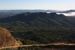 The Northern Coast Range, seen from Saddle Mountain in Clatsop County | |
| Highest point | |
| Peak | Rogers Peak |
| Elevation | 3,706 ft (1,130 m) |
| Coordinates | 45°39′53″N 123°32′53″W / 45.66472°N 123.54806°W / 45.66472; -123.54806Coordinates: 45°39′53″N 123°32′53″W / 45.66472°N 123.54806°W / 45.66472; -123.54806 |
| Dimensions | |
| Length | 100 mi (160 km) north–south |
| Geography | |
| Country | United States |
| State | Oregon |
| Parent range | Oregon Coast Range, Pacific Coast Ranges |
| Borders on | Central Oregon Coast Range |
| Subdivisions | Tualatin Mountains |
| Geology | |
| Orogeny | Geologic fault, basalt flows |
| Age of rock | Paleocene and Eocene |
| Type of rock | volcanic and forearc basin |
The Northern Oregon Coast Range is the northern section of the Oregon Coast Range, in the Pacific Coast Ranges physiographic region, located in the northwest portion of the state of Oregon, United States. This section of the mountain range, part of the Pacific Coast Ranges, contains peaks as high as 3,710 feet (1,131 m) for Rogers Peak.[1] Forests in these mountains are considered to be some of the most productive timber land in the world.[2] The Central Oregon Coast Range is directly south of this section with the Southern Oregon Coast Range beyond the central range.
Contents
1 Geology
2 Flora and fauna
3 Location and climate
4 Peaks
4.1 Other peaks
5 Rivers
6 References
7 External links
Geology
The origins of these mountains began approximately 40 million years ago during the Eocene age. During this time-period, sandstone and siltstone formed in the area. Additionally, igneous rocks and basalt flows combined with basaltic sandstone to create many of the mountainous formations. Other sedimentary rock in the area formed more recently, around 20 million years ago. It is hypothesized that portions of the northern section of the range were islands during parts of the Eocene era.[3] Other portions of the mountains consist of marine sedimentary rock.[4] The entire coast range sits on a convergent tectonic margin interacting with the Juan de Fuca Plate that is subducting beneath North America tectonic plate.[5] Also, weathering and erosion of the region is a major factor in shaping the landscape. Heavy rainfall and landslides have worked to alter the mountains.[4]
The range is part of a broad, plunging structural arch of sedimentary and Tertiary volcanic strata that is being uplifted. Eocene and Miocene sections form the flanks of the uplifted sections. Some of the oldest rocks are submarine tholeiitic basalts from the Eocene era. The basalt came from the basalt flows that covered much of Oregon and originated from volcanoes in the central portion of the state. Other rocks include sandstone, mudstone, and siltstone. It was during the middle Miocene period that the range was uplifted in the broad, northeast-plunging arch.[6]
Flora and fauna

Logging in the mountains

Oregon-grape
Portions of the range are in the Siuslaw National Forest and Tillamook State Forest, and large sections of the range were burned in forest fires during the 1930s and 1940s as part of the Tillamook Burn. In the forested areas trees include Sitka spruce, western redcedar, Douglas-fir, and western hemlock.[7] Other plants that grow in the region are huckleberry, salmonberry, salal, vine maple, sword fern, Oregon grape, bracken fern, and thimble-berry to name a few.[7][8]
Arthropods and molluscs found include millipedes, collembolans, spiders, beetles, slugs, and various centipedes.[7][8] Animals that inhabit the Northern Coast range are weevils, chipmunks, bears, rabbits, white-footed deer mice, Columbian Black tail deer, and others.[8] Birds include chickadees, red-breasted nuthatches, kinglets, Western pileated woodpeckers, Oregon gray jays, California creepers, and Sitka red crossbills among others.[8]
Location and climate
The range begins at the Columbia River, with some mountainous features on the north side of the river, and continues south roughly 100 miles (160 km) to the Salmon River where Oregon Route 18 traverses the range from the Willamette Valley to the Oregon Coast. The width of the range varies but is roughly 35 miles (56 km).[2]
The climate of the range is moderate because of marine influences, and annual precipitation is heavy, varying from 60 to 180 inches (1,500 to 4,600 mm).[9]
Peaks

Fog covering the mountains near Balm Grove

Youngs River, Saddle Mountain (Clatsop County, Oregon) and the Northern Oregon Coast Range from the Astoria Column
All mountains over 3,000 feet (910 m) in elevation in the Northern Coast Range.
| Mountain Name | Elevation | County | |
|---|---|---|---|
| feet | metres | ||
Rogers Peak | 3,706 | 1,130 | Tillamook |
South Saddle Mountain | 3,465 | 1,056 | Washington |
Larch Mountain | 3,452 | 1,052 | Washington |
Trask Mountain | 3,426 | 1,044 | Yamhill |
Saddle Mountain | 3,288 | 1,002 | Clatsop |
Triangulation Point | 3,235 | 986 | Tillamook |
Kings Mountain | 3,226 | 983 | Tillamook |
Mount Hebo | 3,154 | 961 | Yamhill |
Edwards Butte | 3,136 | 956 | Tillamook |
Buck Mountain | 3,097 | 944 | Tillamook |
Sheridan Peak | 3,091 | 942 | Yamhill |
Woods Point | 3,084 | 940 | Tillamook |
Gobblers Knob | 3,058 | 932 | Tillamook |
Onion Peak | 3,057 | 932 | Clatsop |
Other peaks
Round Top (Oregon) 2,982 feet (909 m)
Neahkahnie Mountain 1,634 feet (498 m)
Rivers
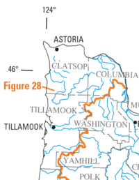
Map of the region with major rivers in blue. Orange line shows divide between watersheds flowing to the east and those flowing north or west.
The following rivers have their headwaters in the Northern Oregon Coast Range:
- Drains to Columbia River:
- Clatskanie River
- John Day River
- Klaskanine River
- Lewis and Clark River
- Skipanon River
- Wallooskee River
- Youngs River
- Drains to Willamette River:
- Tualatin River
- Yamhill River
- Drains to Pacific Ocean:
- Kilchis River
- Miami River
- Necanicum River
- Nehalem River
- Nestucca River
- Salmonberry River
- Salmon River
- Tillamook River
- Trask River
- Wilson River
References
^ Rogers Peak. Peakbagger.com. Retrieved February 29, 2008.
^ ab Northern Coast Range Adaptive Management Area; Chapter 2: Physical and Biological Environment. Oregon State University. Retrieved February 29, 2008.
^ Upper Nehalem Watershed Analysis. (PDF) Oregon Department of Forestry. Retrieved February 29, 2008.
^ ab Byrne, John V. "An Erosional Classification for the Northern Oregon Coast", Annals of the Association of American Geographers, Vol. 54, No. 3. (Sep. 1964), pp. 329–335.
^ Geology of the Luckiamute River Watershed, Upper Willamette Basin, Polk and Benton Counties, Oregon. (PDF) Western Oregon University. Retrieved February 29, 2008.
^ Geologic Map of the Tillamook Highlands, Northwest Oregon Coast Range. U.S. Geological Survey. Retrieved February 29, 2008.
^ abc From the Forest to the Sea: A Story of Fallen Trees. Tree Dictionary. Retrieved February 29, 2008.
^ abcd Macnab, James A. Biotic Aspection in the Coast Range Mountains of Northwestern Oregon. Ecological Monographs, Vol. 28, No. 1. (Jan. 1958), pp. 21–54.
^ Private Forests. Oregon Department of Forestry. Retrieved February 29, 2008.
External links
 Media related to Oregon Coast Range at Wikimedia Commons


