Sutherland
Sutherland | |
|---|---|
Historic county | |
 Flag | |
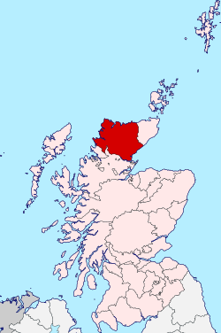 | |
| Country | Scotland |
| County town | Dornoch |
| Area | |
| • Total | 2,028 sq mi (5,252 km2) |
| Ranked 5th of 34 | |
| Population (2011) | |
| • Total | 12,650 |
| • Density | 6.2/sq mi (2.4/km2) |
| Chapman code | SUT |
Sutherland is a historic county, registration county and lieutenancy area in the Highlands of Scotland. Its county town is Dornoch.[1] Sutherland borders Caithness to the east, Ross-shire to the south and the Atlantic to the north and west. Like its southern neighbour Ross-shire, Sutherland has some of the most dramatic scenery in the whole of Europe, especially on its western fringe where the mountains meet the sea. These include high sea cliffs, and very old mountains composed of Precambrian and Cambrian rocks.
The name Sutherland dates from the era of Norwegian Viking rule and settlement over much of the Highlands and Islands, under the rule of the jarl of Orkney. Although it contains some of the northernmost land in the island of Great Britain, it was called Suðrland ("southern land") from the standpoint of Orkney and Caithness. In Gaelic, the area is referred to according to its traditional areas: Dùthaich MhicAoidh (or Dùthaich 'IcAoidh) in the northeast, Asainte (Assynt) in the west, and Cataibh in the east. Cataibh is also sometimes used to refer to the area as a whole. The northwest corner of Sutherland, traditionally known as the Province of Strathnaver, was not incorporated into Sutherland until 1601. This was the home of the powerful and warlike Clan Mackay, and as such was named in Gaelic, Dùthaich 'Ic Aoidh, the Homeland of Mackay. Even today this part of Sutherland is known as Mackay Country, and, unlike other areas of Scotland where the names traditionally associated with the area have become diluted, there is still a preponderance of Mackays in the Dùthaich.
Much of the population is based in coastal towns, such as Helmsdale and Lochinver, which until very recently made much of their living from the rich fishing of the waters around the British Isles. Much of Sutherland is poor relative to the rest of Scotland, with few job opportunities beyond government funded employment, agriculture and seasonal tourism. Further education is provided by North Highland College, part of the University of the Highlands and Islands. The Ross House Campus in Dornoch was the first establishment in the United Kingdom to provide a degree in golf management. The Burghfield House Campus, also in Dornoch, is the home for the Centre for History[2] teaching undergraduate and postgraduate history degrees to students around the UHI network and worldwide.
Contents
1 Landscape
2 Transport
3 Highland Clearances
4 Local government
4.1 Civil parishes
4.2 Community councils
5 Constituency
6 Sutherland in popular culture
7 Notable people with Sutherland connections
8 See also
9 Footnotes
10 External links
Landscape
.mw-parser-output .tmulti .thumbinnerdisplay:flex;flex-direction:column.mw-parser-output .tmulti .trowdisplay:flex;flex-direction:row;clear:left;flex-wrap:wrap;width:100%;box-sizing:border-box.mw-parser-output .tmulti .tsinglemargin:1px;float:left.mw-parser-output .tmulti .theaderclear:both;font-weight:bold;text-align:center;align-self:center;background-color:transparent;width:100%.mw-parser-output .tmulti .thumbcaptiontext-align:left;background-color:transparent.mw-parser-output .tmulti .text-align-lefttext-align:left.mw-parser-output .tmulti .text-align-righttext-align:right.mw-parser-output .tmulti .text-align-centertext-align:center@media all and (max-width:720px).mw-parser-output .tmulti .thumbinnerwidth:100%!important;box-sizing:border-box;max-width:none!important;align-items:center.mw-parser-output .tmulti .trowjustify-content:center.mw-parser-output .tmulti .tsinglefloat:none!important;max-width:100%!important;box-sizing:border-box;text-align:center.mw-parser-output .tmulti .thumbcaptiontext-align:center
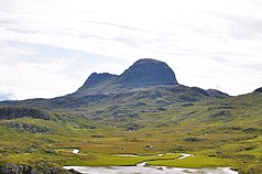
Suilven from the Glencanisp Lodge path
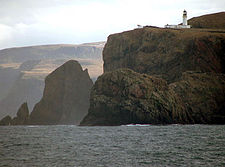
Cape Wrath from the sea
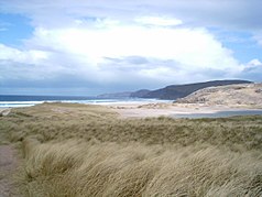
The inland landscape is rugged and very sparsely populated. Despite being Scotland's fifth-largest county in terms of area, it has a smaller population than a medium-size Lowland Scottish town. It stretches from the Atlantic in the west, up to the Pentland Firth and across to the North Sea. The sea-coasts boast very high cliffs and deep fjords in the east and north, ragged inlets on the west and sandy beaches in the north. The remote far northwest point of Sutherland, Cape Wrath, is the most northwesterly point in Scotland. The county has many fine beaches, a remote example being Sandwood Bay, which can only be reached by foot along a rough track. The number of visiting tourists is, naturally, minimal.
Sutherland has many rugged mountains such as Ben Hope, the most northerly Munro. The western part comprises Torridonian sandstone underlain by Lewisian gneiss. The spectacular scenery has been created by denudation to form isolated sandstone peaks such as Foinaven, Arkle, Cùl Mór and Suilven. Such mountains are attractive for hill walking and scrambling, despite their remote location. Together with similar peaks to the south in Wester Ross, such as Stac Pollaidh, they have a unique structure with great scope for exploration. On the other hand, care is needed when bad weather occurs owing to their isolation and the risks of injury.
Owing to its isolation from the rest of the country, Sutherland was reputedly the last haunt of the native wolf, the last survivor being shot in the 18th century. However, other wildlife has survived, including the golden eagle, sea eagle and pine marten amongst other species which are very rare in the rest of the country. There are pockets of the native Scots Pine, remnants of the original Caledonian Forest.
The importance of the county's scenery is recognised by the fact that 4 of Scotland's 40 national scenic areas (NSAs) are located here.[3] The purpose of the NSA designation is to identify areas of exceptional scenery and to ensure its protection from inappropriate development. The areas protected by the designation are considered to represent the type of scenic beauty "popularly associated with Scotland and for which it is renowned".[4] The four NSAs within Sutherland are:
- The Assynt-Coigach NSA has many distinctively shaped mountains, including Quinag, Canisp, Suilven, Cùl Mòr, Stac Pollaidh and Ben More Assynt, that rise steeply from the surrounding "cnoc and lochan" scenery. These can often appear higher than their actual height would indicate due to their steep sides and the contrast with the moorland from which they rise.[5] Assynt lies within Sutherland, whilst Coigach lies within Ross and Cromarty.
- The Dornoch Firth NSA also straddles the boundary between Sutherland and Ross and Cromarty, and covers a variety of landscapes surrounding the narrow and sinuous firth.[5]
- The Kyle of Tongue NSA covers the mountains of Ben Hope and Ben Loyal, as well as woodlands and crofting settlements on the shoreline of the kyle itself.[5]
- The North West Sutherland NSA covers the mountains of Foinaven, Arkle and Ben Stack as well as the coastal scenery surrounding Loch Laxford and Handa Island.[5]
Transport
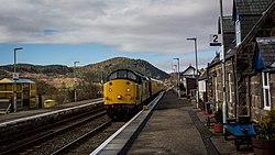
Rogart railway station on the Far North Line
The A9 road main east coast road is challenging north of Helmsdale, particularly at the notorious Berriedale Braes, and there are few inland roads. The Far North Line north-south single-track railway line was extended through Sutherland by the Highland Railway between 1868 and 1871. It enters Sutherland near Invershin and runs along the east coast as far as possible, but an inland diversion was necessary from Helmsdale along the Strath of Kildonan. The line exits to the east of Forsinard.
Helmsdale is on the A9 road, at a junction with the A897, and has a railway station on the Far North Line. Buses operate about every two hours Mondays-Saturdays and infrequently on Sundays from Helmsdale to Brora, Golspie, Dornoch, Tain and Inverness in the south, and Berriedale, Dunbeath, Halkirk, Thurso and Scrabster in the north. These are on route X99 and are operated by Stagecoach in the Highlands, but tickets can be bought on the Citylink website.
There are no airports.
Highland Clearances
| Historical Sutherland population | ||
|---|---|---|
| Year | Pop. | ±% |
| 1801 | 23,117 | — |
| 1811 | 23,629 | +2.2% |
| 1821 | 23,840 | +0.9% |
| 1831 | 25,518 | +7.0% |
| 1841 | 24,782 | −2.9% |
| 1851 | 25,793 | +4.1% |
| 1861 | 24,157 | −6.3% |
| 1871 | 23,298 | −3.6% |
| 1881 | 22,376 | −4.0% |
| 1891 | 21,896 | −2.1% |
| 1901 | 21,440 | −2.1% |
| 1911 | 20,179 | −5.9% |
| 1921 | 17,802 | −11.8% |
| 1931 | 16,101 | −9.6% |
| 1951 | 13,670 | −15.1% |
| 1961 | 13,507 | −1.2% |
| 1971 | 13,055 | −3.3% |
| 2011 | 12,650 | −3.1% |
| Source: Vision of Britain | ||
Sutherland is perhaps best known for the Highland Clearances, the eviction of tenants from their homes and/or associated farmland in the 18th and 19th centuries century by the landowners. Typically, this was to make way for large sheep farms. The Sutherland Estate (consisting of about two thirds of the county) had the largest scale clearances that occurred in the Highlands, much of this being carried out in 1812, 1814 and 1819-20. In this last period (the largest of the three listed), 1,068 families were evicted: representing an estimated 5,400 people. This population was provided with resettlement in coastal areas, with employment available in fishing or other industries. However, many instead moved to farms in Caithness or left Scotland to emigrate to Canada, the USA or Australia.[6]
It was the villages produced by this policy that formed the last Gaelic speaking communities to be found on the east coast of Scotland, as discovered by Nancy Dorian in the early 1960s, and there are still some native speakers of the East Sutherland dialect of Gaelic in this area.[7]
Local government
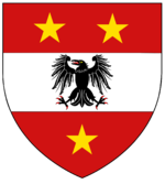
Arms of the former Sutherland County Council
In 1890 Sutherland became a local government county, with its own elected county council, under the Local Government (Scotland) Act 1889. At that time, one town within the county, Dornoch, was already well established as an autonomous burgh with its own burgh council. Dornoch, a royal burgh, had its own Burgh Council but did not serve as the county's administrative centre. The County Offices for Sutherland had always been in Golspie and remained so with the new County Offices at Drummuie.
In 1975 the Local Government council and the burgh council were superseded under the Local Government (Scotland) Act 1973. The 1973 act also created a new two-tier system, with Sutherland becoming part of Highland region. The county was divided between districts entitled Caithness and Sutherland, two of the eight districts with Highland. The Tongue and Farr areas of the county of Sutherland became part of the Caithness district (which also included the entirity of the county of Caithness); additionally the Kincardine area of the county of Ross and Cromarty was merged into the new Sutherland district. Shortly after its creation, however the boundary between the districts of Sutherland and Caithness were redrawn to follow that between the counties.
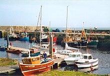
The harbour at Helmsdale
In 1996 local government in Scotland was again reformed, by the Local Government etc (Scotland) Act 1994, which created 32 unitary council areas. The Highland council region became the Highland unitary council area, and the functions of the district councils were absorbed by the Highland Council. The new Highland Council then adopted the former districts as management areas and created a system of area committees to represent them. Until 1999 the Sutherland management and committee areas consisted of seven out of the 72 Highland Council wards. Each ward elected one councillor by the first past the post system of election. In 1999, however, ward boundaries were redrawn, but management area boundaries were not. As a result, area committees were named for and made decisions for areas which they did not exactly represent. The new Sutherland committee area consisted of six out of the 80 new Highland Council wards.
In 2007 new multi-member wards were created for elections under the single transferable vote (STV) electoral system. Some local decisions are delegated to the Sutherland County Committee, which consists of all councillors representing Sutherland.[8]
Civil parishes
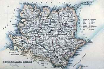
An 1861 map of Sutherland, with its parishes outlined in red
In 1894 Parish councils covering rural areas of the county were established. In 1931 the parish councils were superseded under the Local Government (Scotland) Act 1929.
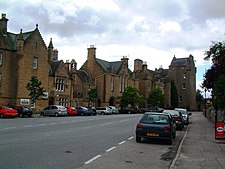
Castle Street in the Royal Burgh of Dornoch
Civil parishes are still used for some statistical purposes, and separate census figures are published for them. As their areas have been largely unchanged since the 19th century this allows for comparison of population figures over an extended period of time. (Refer to map:[9]) The following individual parish population figures, giving a total population of 12,650 at the 2011 Census for the 13 Civil Parishes (1930 boundaries), were extracted from Census Table QS112SC using the interactive Standard Outputs system at the Scotland's Census website.[10]
Of the 871 civil parishes in Scotland listed on the General Register Office for Scotland website,[11] 13 are identified on the Wikipedia list of civil parishes in Scotland as being in Sutherland. In addition, the list states that Reay used to be partly in Sutherland, until 1891.
Assynt: 1,011- Clyne (see Brora): 1,765
Creich: 1,106
Dornoch: 2,402
Durness: 345- Eddrachillis (see Kinlochbervie, Scourie): 674
Farr: 945
Golspie: 1,641- Kildonan (see Helmsdale): 725
Lairg: 887- Loth (see Lothbeg): 139
Rogart: 458
Tongue: 552
Other settlements include:
- Bonar Bridge
- Brora
- Embo
- Helmsdale
- Kinlochbervie
- Lochinver
- Scourie
- Strathy
Community councils
Although created under local government legislation (the Local Government (Scotland) Act 1973) community councils have no statutory powers or responsibilities and are not a tier of local government. They are however the most local tier of statutory representation. Here is a list of Highland Community Councils (scroll to Sutherland). Under the 1973 act, they were created in terms of community council schemes created by the district councils which were created under the same act. The Sutherland district scheme was adopted in 1975. Statutory status for community councils was continued under the Local Government etc (Scotland) Act 1994, and the Sutherland scheme is now the responsibility of the Highland Council.
Constituency
The Sutherland constituency of the House of Commons of the Parliament of the United Kingdom represented the county from 1708 to 1918. At the same time however the county town of Dornoch was represented as a component of the Northern Burghs constituency. In 1918 the Sutherland constituency and Dornoch were merged into the then new constituency of Caithness and Sutherland. In 1997 Caithness and Sutherland was merged into Caithness, Sutherland and Easter Ross.
The Scottish Parliament constituency of Caithness, Sutherland and Easter Ross was created in 1999 for the newly established parliament. The constituency was extended for the 2011 election to include more of Ross-shire, and was so renamed Caithness, Sutherland and Ross. In the Scottish Parliament, Sutherland is represented also as part of the Highlands and Islands electoral region.
Sutherland in popular culture
In M. C. Beaton's Hamish Macbeth mystery series, the fictional towns of Lochdubh and Strathbane are located in Sutherland.
Rosamunde Pilcher's last novel Winter Solstice is largely set in and around the fictional Sutherland town of Creagan, located in the Sutherland town of Dornoch.
Notable people with Sutherland connections
George Mackay Brown (1921–1996), 'Bard of Orkney', whose mother was born in Strathy
John Lennon (1940–1980), a frequent visitor to Durness, on which the song 'In My Life' was reputedly based
Norman MacCaig (1910–1996), Edinburgh born poet, who visited, and wrote about, the region of Assynt, which he visited many times over a period of forty years.
Patrick Sellar (1780–1851), lawyer and factor
W.C. Sellar (1898–1951), humourist who wrote for Punch, best known for the book 1066 and All That
William Young Sellar (1825–1890), classical scholar
Joe Strummer (1952–2002), frontman of the Clash; born John Graham Mellor in Ankara, Turkey; his mother, Anna Mackenzie, was a crofter's daughter born and raised in Bonar Bridge
See also
- Subdivisions of Scotland
- Clan Sutherland
- List of counties of Scotland 1890–1975
- Medieval Diocese of Caithness
Footnotes
^ Macrae, Kenneth (30 September 1971). "Fine roads and sandy beaches". The Glasgow Herald. p. 5. Retrieved 3 April 2016..mw-parser-output cite.citationfont-style:inherit.mw-parser-output .citation qquotes:"""""""'""'".mw-parser-output .citation .cs1-lock-free abackground:url("//upload.wikimedia.org/wikipedia/commons/thumb/6/65/Lock-green.svg/9px-Lock-green.svg.png")no-repeat;background-position:right .1em center.mw-parser-output .citation .cs1-lock-limited a,.mw-parser-output .citation .cs1-lock-registration abackground:url("//upload.wikimedia.org/wikipedia/commons/thumb/d/d6/Lock-gray-alt-2.svg/9px-Lock-gray-alt-2.svg.png")no-repeat;background-position:right .1em center.mw-parser-output .citation .cs1-lock-subscription abackground:url("//upload.wikimedia.org/wikipedia/commons/thumb/a/aa/Lock-red-alt-2.svg/9px-Lock-red-alt-2.svg.png")no-repeat;background-position:right .1em center.mw-parser-output .cs1-subscription,.mw-parser-output .cs1-registrationcolor:#555.mw-parser-output .cs1-subscription span,.mw-parser-output .cs1-registration spanborder-bottom:1px dotted;cursor:help.mw-parser-output .cs1-ws-icon abackground:url("//upload.wikimedia.org/wikipedia/commons/thumb/4/4c/Wikisource-logo.svg/12px-Wikisource-logo.svg.png")no-repeat;background-position:right .1em center.mw-parser-output code.cs1-codecolor:inherit;background:inherit;border:inherit;padding:inherit.mw-parser-output .cs1-hidden-errordisplay:none;font-size:100%.mw-parser-output .cs1-visible-errorfont-size:100%.mw-parser-output .cs1-maintdisplay:none;color:#33aa33;margin-left:0.3em.mw-parser-output .cs1-subscription,.mw-parser-output .cs1-registration,.mw-parser-output .cs1-formatfont-size:95%.mw-parser-output .cs1-kern-left,.mw-parser-output .cs1-kern-wl-leftpadding-left:0.2em.mw-parser-output .cs1-kern-right,.mw-parser-output .cs1-kern-wl-rightpadding-right:0.2em
^ https://www.uhi.ac.uk/en/research-enterprise/cultural/centre-for-history/
^ "Map: National Scenic Areas of Scotland" (PDF). Scottish Government. 1998. Retrieved 2018-05-16.
^ "Countryside and Landscape in Scotland - National Scenic Areas". Scottish Government. 2017-07-04. Retrieved 2018-01-31.
^ abcd "The special qualities of the National Scenic Areas" (PDF). Scottish Natural Heritage. 2010. Retrieved 2018-01-24.
^ Richards, Eric (2000). The Highland Clearances People, Landlords and Rural Turmoil (2013 ed.). Edinburgh: Birlinn Limited. ISBN 978-1-78027-165-1.
^ [1] Archived April 18, 2011, at the Wayback Machine
^ "Sutherland County Committee: Tasks and responsibilities". Highland Council. Retrieved 2018-12-06.
^ "Old Roads of Scotland". Old Roads of Scotland. Retrieved 2014-10-01.
^ GROS. "Standard Outputs - Census Data Explorer - Scotland's Census". www.scotlandscensus.gov.uk. Retrieved 27 March 2018.
^ "2001 Census - Geography Classifications" (PDF). gro-scotland.gov.uk. Archived from the original (PDF) on 19 March 2012. Retrieved 27 March 2018.
^1 Sutherland derives from a Norse perception of the land as 'southern' (Suðrland meaning "Southland"). The Norse referred similarly to the Western Isles as Suðreyjar (the "Southern Isles"), southern in relation to the "Northern Isles" of Orkney, Shetland and the Faroe Islands.
^2 Sutherland has two main names in the local, indigenous Scottish Gaelic: Cataibh may be used for the whole of Sutherland, but tended historically to apply to the south east, and Dùthaich MhicAoidh (Mackay Country) which was used for the north west, sometimes referred to as Reay Country in English. Cataibh can be read as meaning among the Cats and the Cat element appears as Cait in Caithness. The Scottish Gaelic name for Caithness, however, is Gallaibh, meaning among the Strangers (i.e. the Norse who extensively settled there).
External links
| Wikimedia Commons has media related to Sutherland. |
Map of Sutherland on Wikishire
"Small Area Population Estimates 2004" (PDF). Archived from the original (PDF) on 2009-03-26. (412 KB) (www.highland.gov.uk)
Miss Dempster "Folk-Lore of Sutherlandshire" Folk-Lore Journal. Volume 6, 1888.
Coordinates: 58°15′N 4°30′W / 58.250°N 4.500°W / 58.250; -4.500


