Borišov
| Borišov | |
|---|---|
 | |
| Highest point | |
| Elevation | 1,509.5 m (4,952 ft) |
| Coordinates | 48°56′28.2″N 19°05′22.2″E / 48.941167°N 19.089500°E / 48.941167; 19.089500Coordinates: 48°56′28.2″N 19°05′22.2″E / 48.941167°N 19.089500°E / 48.941167; 19.089500 |
| Geography | |
 Borišov Location in Slovakia | |
| Location | Martin, Žilina, Slovakia |
| Parent range | Greater Fatra |
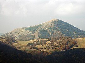
Borišov is a mountain in the Greater Fatra Range in Slovakia measuring 1,508.5 m (4,949.1 ft). Its summit is deforested, covered in grass. On the southern side there is one of the largest avalanche slopes in Slovakia. The Borišov National Nature Reserve protects a well-preserved primeval mountain forest on the northern side of the mountain.
In the saddle between Borišov and Ploská there is the year-round open Chata pod Borišovom (i.e. Chalet under Borišov).
References
.mw-parser-output .refbeginfont-size:90%;margin-bottom:0.5em.mw-parser-output .refbegin-hanging-indents>ullist-style-type:none;margin-left:0.mw-parser-output .refbegin-hanging-indents>ul>li,.mw-parser-output .refbegin-hanging-indents>dl>ddmargin-left:0;padding-left:3.2em;text-indent:-3.2em;list-style:none.mw-parser-output .refbegin-100font-size:100%
Brandos, Otakar (2004). Veľká Fatra, Šípska Fatra. Ostrava: SKY. ISBN 80-86774-02-3..mw-parser-output cite.citationfont-style:inherit.mw-parser-output .citation qquotes:"""""""'""'".mw-parser-output .citation .cs1-lock-free abackground:url("//upload.wikimedia.org/wikipedia/commons/thumb/6/65/Lock-green.svg/9px-Lock-green.svg.png")no-repeat;background-position:right .1em center.mw-parser-output .citation .cs1-lock-limited a,.mw-parser-output .citation .cs1-lock-registration abackground:url("//upload.wikimedia.org/wikipedia/commons/thumb/d/d6/Lock-gray-alt-2.svg/9px-Lock-gray-alt-2.svg.png")no-repeat;background-position:right .1em center.mw-parser-output .citation .cs1-lock-subscription abackground:url("//upload.wikimedia.org/wikipedia/commons/thumb/a/aa/Lock-red-alt-2.svg/9px-Lock-red-alt-2.svg.png")no-repeat;background-position:right .1em center.mw-parser-output .cs1-subscription,.mw-parser-output .cs1-registrationcolor:#555.mw-parser-output .cs1-subscription span,.mw-parser-output .cs1-registration spanborder-bottom:1px dotted;cursor:help.mw-parser-output .cs1-ws-icon abackground:url("//upload.wikimedia.org/wikipedia/commons/thumb/4/4c/Wikisource-logo.svg/12px-Wikisource-logo.svg.png")no-repeat;background-position:right .1em center.mw-parser-output code.cs1-codecolor:inherit;background:inherit;border:inherit;padding:inherit.mw-parser-output .cs1-hidden-errordisplay:none;font-size:100%.mw-parser-output .cs1-visible-errorfont-size:100%.mw-parser-output .cs1-maintdisplay:none;color:#33aa33;margin-left:0.3em.mw-parser-output .cs1-subscription,.mw-parser-output .cs1-registration,.mw-parser-output .cs1-formatfont-size:95%.mw-parser-output .cs1-kern-left,.mw-parser-output .cs1-kern-wl-leftpadding-left:0.2em.mw-parser-output .cs1-kern-right,.mw-parser-output .cs1-kern-wl-rightpadding-right:0.2em
VKÚ Harmanec (2003). Veľká Fatra. Edícia turistických máp 1:50000. Harmanec: VKÚ. ISBN 80-8042-044-0.


