Alapaha River
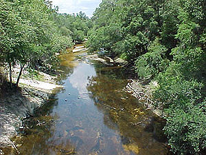
The Alapaha River at Statenville, Georgia, during a period of drought in 2000

The Alapaha River /əˈlæpəhɑː/ is a 202-mile-long (325 km)[1]river in southern Georgia and northern Florida in the United States. It is a tributary of the Suwannee River, which flows to the Gulf of Mexico.
Contents
1 History
2 Course
3 Intermittent river
4 Variant names
5 Crossings
5.1 Georgia
5.2 Florida
6 References
7 External links
History
The Hernando de Soto expedition narrative records mention a "Yupaha" village they encountered after they left Apalachee, "the sound of which is suggestive of the Alapaha, a tributary of the Suwanee."[2] Another reference to a village of "Atapaha" "so closely resembles Alapaha that it is reasonable to suppose they are the same, and that the town was on the river of that name."[3] John Reed Swanton's landmark Indian Tribes of North America places the Indian village of Alapaha near where the Alapaha River met the Suwanee, and also noted that an Indian village of "Arapaja" was 70 leagues from St. Augustine, Florida, probably on the Alapaha River.[4]
In the 1840s a German travel writer, Friedrich Gerstäcker wrote a dime novel called Alapaha, or the Renegades of the Border, giving the name to a noble Cherokee "squaw." A translation of this novel was published in the 1870s as #67 in a series of American narratives published by Beadle.[5]
During the American Civil War, the swamps along the Alapaha River in Berrien, Irwin, and Echols counties became a refuge for a number of gangs of Confederate deserters.[6]
Course
The Alapaha River rises in southeastern Dooly County, Georgia, and flows generally southeastwardly through or along the boundaries of Crisp, Wilcox, Turner, Ben Hill, Irwin, Tift, Berrien, Atkinson, Lanier, Lowndes and Echols Counties in Georgia, and Hamilton County in Florida, where it flows into the Suwannee River 10 miles (16 km) southwest of Jasper. Along its course it passes the Georgia towns of Rebecca, Alapaha, Willacoochee, Lakeland, and Statenville.
Near Willacoochee, Georgia, the Alapaha collects the Willacoochee River. In Florida, it collects the Alapahoochee River and the short Little Alapaha River, which rises in Echols County, Georgia, and flows southwestward.
Intermittent river
The Alapaha River is an intermittent river for part of its course. During periods of low volume, the river disappears underground and becomes a subterranean river. At approximately 2.3 miles (3.7 km) downstream from Jennings, Florida the Dead River enters the Alapaha River. It is a usually dry river bed with a number of sinkholes, including the Dead River Sink. During periods of low water flow, the Alapaha River downstream from the confluence of the Dead River and the Alapaha River flows upstream into the Dead River.

The Dead River Sink
A few more miles downstream is a second sinkhole variously known as the Alapaha River Sink, Suck Hole, or the Devil's Den on the western bank of the river. At the latter point during the periods of low water flow, the Alapaha River disappears underground leaving a dry bank for much of the remainder of its course. The Alapaha River later reappears at the Alapaha River Rise, which is about a half mile upstream from the confluence of the Alapaha River and the Suwanee River (30°26′46″N 83°05′51″W / 30.446044°N 83.097483°W / 30.446044; -83.097483). During a period of low rainfall over 11 miles (18 km) of the riverbed can be dry as the river goes underground.

Image of the entire surface water flow of the Alapaha River near Jennings, Florida going into a sinkhole leading to the Floridan aquifer groundwater.
Variant names
The United States Board on Geographic Names settled on "Alapaha River" as the stream's name in 1891. According to the Geographic Names Information System, it has also been known as:
|
|
|
Crossings
| Crossing | Carries | Image | Location | ID number | Coordinates |
|---|---|---|---|---|---|
| |||||
| Griffin Road | 32°01′27″N 83°36′37″W / 32.0243°N 83.6103°W / 32.0243; -83.6103 | ||||
| Buzzard Bridge | Willford Crossing Road | 32°01′27″N 83°36′37″W / 32.0243°N 83.6103°W / 32.0243; -83.6103 | |||
| County Line Road | 32°01′11″N 83°36′37″W / 32.0198°N 83.6103°W / 32.0198; -83.6103 | ||||
| Seville Road | 32°00′32″N 83°36′06″W / 32.0089°N 83.6016°W / 32.0089; -83.6016 | ||||
| Seville Road | 32°00′32″N 83°36′06″W / 32.0089°N 83.6016°W / 32.0089; -83.6016 | ||||
| Seville-Pleasantview Road | 31°59′50″N 83°35′27″W / 31.9973°N 83.5908°W / 31.9973; -83.5908 | ||||
| Old Cordele Road | 31°59′07″N 83°34′40″W / 31.9853°N 83.5778°W / 31.9853; -83.5778 | ||||
| Flowers Road | 31°58′39″N 83°34′34″W / 31.9775°N 83.5761°W / 31.9775; -83.5761 | ||||
| Watson Road | 31°58′01″N 83°34′38″W / 31.9670°N 83.5771°W / 31.9670; -83.5771 | ||||
| Dowley Road | 31°56′52″N 83°33′37″W / 31.9478°N 83.5604°W / 31.9478; -83.5604 | ||||
| Rail bridge | CSX Transportation Line formerly known as Savannah, Americus and Montgomery Railway | 31°56′52″N 83°33′37″W / 31.9478°N 83.5604°W / 31.9478; -83.5604 | |||
Pitts, Georgia to Seville, Georgia | 31°55′52″N 83°33′10″W / 31.9312°N 83.5527°W / 31.9312; -83.5527 | ||||
| Highway later replaced by | 31°55′52″N 83°33′10″W / 31.9312°N 83.5527°W / 31.9312; -83.5527 | ||||
31°55′49″N 83°33′07″W / 31.9303°N 83.5519°W / 31.9303; -83.5519 | |||||
Hawkinsville and Florida Southern Railway (Abandoned 1920s) | 31°55′24″N 83°32′43″W / 31.9234°N 83.5453°W / 31.9234; -83.5453 | ||||
31°51′31″N 83°28′47″W / 31.8587°N 83.4797°W / 31.8587; -83.4797 | |||||
| Jay Calhoun Road | 31°51′31″N 83°28′47″W / 31.8587°N 83.4797°W / 31.8587; -83.4797 | ||||
Rebecca, Georgia | 31°46′17″N 83°27′17″W / 31.7714°N 83.4547°W / 31.7714; -83.4547 | ||||
| Rail bridge | CSX Transportation Line formerly known as Atlanta, Birmingham and Atlantic Railway | 31°46′17″N 83°27′17″W / 31.7714°N 83.4547°W / 31.7714; -83.4547 | |||
Hawkinsville and Florida Southern Railway (Abandoned since before the 1920s) | 31°46′17″N 83°27′17″W / 31.7714°N 83.4547°W / 31.7714; -83.4547 | ||||
31°41′24″N 83°27′41″W / 31.6899°N 83.4615°W / 31.6899; -83.4615 | |||||
| Walker Ford | 31°41′24″N 83°27′41″W / 31.6899°N 83.4615°W / 31.6899; -83.4615 | ||||
| Flat Ford | 31°40′53″N 83°27′44″W / 31.6814°N 83.4621°W / 31.6814; -83.4621 | ||||
| Crystal Lake Road | 31°40′38″N 83°27′37″W / 31.6772°N 83.4602°W / 31.6772; -83.4602 | ||||
31°31′58″N 83°23′56″W / 31.5327°N 83.3989°W / 31.5327; -83.3989 | |||||
Tifton and Northeastern Railroad (Line abandoned in the 1960s, defunct) | 31°32′59″N 83°24′54″W / 31.5497°N 83.4151°W / 31.5497; -83.4151 | ||||
| Lennon Bridge | 31°31′58″N 83°23′56″W / 31.5327°N 83.3989°W / 31.5327; -83.3989 | ||||
| 5 Bridge Road | 31°28′45″N 83°20′41″W / 31.4791°N 83.3447°W / 31.4791; -83.3447 | ||||
| McMillan Bridge | 31°25′49″N 83°14′44″W / 31.4303°N 83.2456°W / 31.4303; -83.2456 | ||||
| Sgt. James E. Jones Memorial Bridge | 31°22′17″N 83°10′17″W / 31.3714°N 83.1713°W / 31.3714; -83.1713 | ||||
| Rail bridge | CSX Transportation Line formally known as the Brunswick and Albany Railroad | 31°22′17″N 83°10′17″W / 31.3714°N 83.1713°W / 31.3714; -83.1713 | |||
| PVT. George W. Lee Memorial Bridge | 31°18′11″N 83°03′12″W / 31.302988°N 83.053354°W / 31.302988; -83.053354 | ||||
Norfolk Southern Railway Line formerly known as Ocilla, Pinebloom and Valdosta Railroad | 31°03′14″N 83°02′23″W / 31.053811°N 83.039627°W / 31.053811; -83.039627 | ||||
| Mud Creek Bridge | 31°09′25″N 83°02′22″W / 31.156844°N 83.039514°W / 31.156844; -83.039514 | ||||
| Waycross and Western Railroad (Closed 1925, defunct) | 31°03′14″N 83°02′23″W / 31.053811°N 83.039627°W / 31.053811; -83.039627 | ||||
| Knight's Bridge | |||||
| Captain Henry Will Jones Bridge | Lakeland, Georgia to Homerville, Georgia | 31°02′46″N 83°02′36″W / 31.046217°N 83.043361°W / 31.046217; -83.043361 | |||
| Carters Ferry/Bridge | (Defunct) | Lakeland, Georgia to Magnolia, Georgia. | |||
| Hotchkiss Bridge | Old State Road/Old River/Hotchiss Road (Built 1895, defunct) | 30°56′11″N 83°02′26″W / 30.936513°N 83.040614°W / 30.936513; -83.040614 | |||
Naylor, Georgia to Stockton, Georgia | 30°55′28″N 83°02′14″W / 30.924563°N 83.037216°W / 30.924563; -83.037216 | ||||
| Rail bridge | CSX Transportation Line formerly known as the Atlantic and Gulf Railroad (1856–79) | 30°55′27″N 83°02′13″W / 30.924074°N 83.036841°W / 30.924074; -83.036841 | |||
| Lee Bridge | (Defunct) | 30°51′30″N 83°01′25″W / 30.858398°N 83.023588°W / 30.858398; -83.023588 | |||
| Howells Ferry/Bridge | Howell Road (Old route, defunct) | Mayday, Georgia | 30°49′43″N 83°01′07″W / 30.828749°N 83.018640°W / 30.828749; -83.018640 | ||
| Howell Road | Mayday, Georgia | 30°49′41″N 83°01′07″W / 30.828193°N 83.018549°W / 30.828193; -83.018549 | |||
| Rail bridge | Norfolk Southern Railway Line formerly known as the Atlantic, Valdosta and Western Railway | Mayday, Georgia | 30°49′37″N 83°01′06″W / 30.826888°N 83.018458°W / 30.826888; -83.018458 | ||
| Formally the location of Troublesome Ford | Statenville, Georgia | 30°42′14″N 83°01′58″W / 30.703908°N 83.032683°W / 30.703908; -83.032683 | |||
| |||||
Jennings, Florida to Jasper, Florida | 30°35′54″N 83°04′24″W / 30.598471°N 83.073230°W / 30.598471; -83.073230 | ||||
| Rail bridge | Norfolk Southern Railway Line formerly known as Georgia Southern and Florida Railway | 30°35′53″N 83°04′24″W / 30.598135°N 83.073226°W / 30.598135; -83.073226 | |||
| NW 14th Terrace (Defunct) | 30°35′37″N 83°03′55″W / 30.593586°N 83.065301°W / 30.593586; -83.065301 | ||||
Jennings, Florida to Jasper, Florida | 30°31′44″N 83°02′18″W / 30.528814°N 83.038319°W / 30.528814; -83.038319 | ||||
30°29′57″N 83°02′27″W / 30.499170°N 83.040930°W / 30.499170; -83.040930 | |||||
| (Defunct) | 30°27′12″N 83°05′22″W / 30.453340°N 83.089351°W / 30.453340; -83.089351 | ||||
| SW County Road 751 | Alapaha River Rise | 30°26′55″N 83°05′49″W / 30.448605°N 83.096923°W / 30.448605; -83.096923 | |||
References
^ U.S. Geological Survey. National Hydrography Dataset high-resolution flowline data. The National Map Archived 2012-04-05 at WebCite, accessed April 18, 2011
^ George Ransford Fairbanks, History of Florida from its discovery by Ponce de Leon, in 1512 to the close of the Florida War in 1842. Philadelphia: J.P. Lippincott & Co., 1871, p. 60.
^ Fairbanks, p. 76.
^ John Reed Swanton, Indian Tribes of North America, p. 147.
^ Alapaha, the squaw or, The renegades of the border [WorldCat.org]
^ "Disgraceful". Albany Patriot. Albany, Georgia. 23 February 1865. Retrieved 2 September 2016..mw-parser-output cite.citationfont-style:inherit.mw-parser-output .citation qquotes:"""""""'""'".mw-parser-output .citation .cs1-lock-free abackground:url("//upload.wikimedia.org/wikipedia/commons/thumb/6/65/Lock-green.svg/9px-Lock-green.svg.png")no-repeat;background-position:right .1em center.mw-parser-output .citation .cs1-lock-limited a,.mw-parser-output .citation .cs1-lock-registration abackground:url("//upload.wikimedia.org/wikipedia/commons/thumb/d/d6/Lock-gray-alt-2.svg/9px-Lock-gray-alt-2.svg.png")no-repeat;background-position:right .1em center.mw-parser-output .citation .cs1-lock-subscription abackground:url("//upload.wikimedia.org/wikipedia/commons/thumb/a/aa/Lock-red-alt-2.svg/9px-Lock-red-alt-2.svg.png")no-repeat;background-position:right .1em center.mw-parser-output .cs1-subscription,.mw-parser-output .cs1-registrationcolor:#555.mw-parser-output .cs1-subscription span,.mw-parser-output .cs1-registration spanborder-bottom:1px dotted;cursor:help.mw-parser-output .cs1-ws-icon abackground:url("//upload.wikimedia.org/wikipedia/commons/thumb/4/4c/Wikisource-logo.svg/12px-Wikisource-logo.svg.png")no-repeat;background-position:right .1em center.mw-parser-output code.cs1-codecolor:inherit;background:inherit;border:inherit;padding:inherit.mw-parser-output .cs1-hidden-errordisplay:none;font-size:100%.mw-parser-output .cs1-visible-errorfont-size:100%.mw-parser-output .cs1-maintdisplay:none;color:#33aa33;margin-left:0.3em.mw-parser-output .cs1-subscription,.mw-parser-output .cs1-registration,.mw-parser-output .cs1-formatfont-size:95%.mw-parser-output .cs1-kern-left,.mw-parser-output .cs1-kern-wl-leftpadding-left:0.2em.mw-parser-output .cs1-kern-right,.mw-parser-output .cs1-kern-wl-rightpadding-right:0.2em
External links
| Wikimedia Commons has media related to Alapaha River. |
- Columbia Gazetteer of North America entry
DeLorme (2003). Georgia Atlas & Gazetteer. Yarmouth, Maine: DeLorme.
ISBN 0-89933-253-6.- U.S. Geological Survey Geographic Names Information System: Alapaha River
- U.S. Geological Survey Geographic Names Information System: Little Alapaha River
- Underground: The Alapaha River as an Intermittent River
Coordinates: 30°26′12″N 83°05′47″W / 30.4366062°N 83.0965262°W / 30.4366062; -83.0965262


