Fidalgo Island
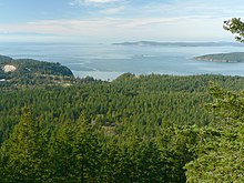
The forested western slopes of Fidalgo Island overlook the Strait of Juan de Fuca.
Fidalgo Island is an island in Skagit County, Washington, located about 60 mi (97 km) north of Seattle. To the east, it is separated from the mainland by the Swinomish Channel, and from Whidbey Island to the south by Deception Pass. The island is named after the Spanish explorer and cartographer Salvador Fidalgo who explored the area in 1790.
Its largest city is Anacortes with a population of 15,778 according to the 2010 Census.[1]Ferries leave daily from Anacortes to Sidney, British Columbia, and several ports in the San Juan Islands.
Contents
1 Geography
2 History
3 Transportation
4 Notable residents
5 See also
6 Notes
7 References
8 External links
Geography
Fidalgo Island has a land area of 106.684 km² (41.19 sq mi). There are at least eight major lakes on Fidalgo Island: Campbell, Little Cranberry, Erie, Heart, Mud, Pass, Trafton/Crater, and Whistle.
History

Southeastern Fidalgo Island with Lake Campbell (lower right) and Swinomish Indian Reservation just beyond Similk Bay (middle)
Fidalgo Island was originally inhabited by the Samish and Swinomish peoples.
Fidalgo Island is named for the Spanish explorer and cartographer Salvador Fidalgo[2] who explored the area in 1790 with the fleet of Francisco de Eliza. Charles Wilkes discovered that it was an island rather than part of the mainland. He named it Perry Island in honor of Oliver Hazard Perry, the American commander who won the Battle of Lake Erie during the War of 1812. Following this theme, Wilkes named the island's highest point Mount Erie. When Henry Kellett reorganized the official British Admiralty charts in 1847, he removed Wilkes' name Perry and bestowed the name Fidalgo to honor the Spanish explorer. The highest point retained the name Erie.[3]
Settlement peaked in the 1850s due to the Fraser River Gold Rush and in 1890 due to speculation that the area would become a terminus of the Northern Pacific Railroad. Later the island became an important fishing and lumber center.
Transportation
From 1924 to 1935, Fidalgo Island was linked to Whidbey Island by the Deception Pass ferry, which was superseded in 1935 by the construction of the Deception Pass Bridge. Today, Fidalgo Island is the site of the main ferry terminal that links the San Juan Islands to the rest of the state.
Notable residents
Morris Graves, painter
Phil Elverum, musician
See also
- List of islands of Washington State by population and area
Notes
^ "American FactFinder". United States Census Bureau. Retrieved 2014-08-10..mw-parser-output cite.citationfont-style:inherit.mw-parser-output .citation qquotes:"""""""'""'".mw-parser-output .citation .cs1-lock-free abackground:url("//upload.wikimedia.org/wikipedia/commons/thumb/6/65/Lock-green.svg/9px-Lock-green.svg.png")no-repeat;background-position:right .1em center.mw-parser-output .citation .cs1-lock-limited a,.mw-parser-output .citation .cs1-lock-registration abackground:url("//upload.wikimedia.org/wikipedia/commons/thumb/d/d6/Lock-gray-alt-2.svg/9px-Lock-gray-alt-2.svg.png")no-repeat;background-position:right .1em center.mw-parser-output .citation .cs1-lock-subscription abackground:url("//upload.wikimedia.org/wikipedia/commons/thumb/a/aa/Lock-red-alt-2.svg/9px-Lock-red-alt-2.svg.png")no-repeat;background-position:right .1em center.mw-parser-output .cs1-subscription,.mw-parser-output .cs1-registrationcolor:#555.mw-parser-output .cs1-subscription span,.mw-parser-output .cs1-registration spanborder-bottom:1px dotted;cursor:help.mw-parser-output .cs1-ws-icon abackground:url("//upload.wikimedia.org/wikipedia/commons/thumb/4/4c/Wikisource-logo.svg/12px-Wikisource-logo.svg.png")no-repeat;background-position:right .1em center.mw-parser-output code.cs1-codecolor:inherit;background:inherit;border:inherit;padding:inherit.mw-parser-output .cs1-hidden-errordisplay:none;font-size:100%.mw-parser-output .cs1-visible-errorfont-size:100%.mw-parser-output .cs1-maintdisplay:none;color:#33aa33;margin-left:0.3em.mw-parser-output .cs1-subscription,.mw-parser-output .cs1-registration,.mw-parser-output .cs1-formatfont-size:95%.mw-parser-output .cs1-kern-left,.mw-parser-output .cs1-kern-wl-leftpadding-left:0.2em.mw-parser-output .cs1-kern-right,.mw-parser-output .cs1-kern-wl-rightpadding-right:0.2em
^ Gannett, Henry (1905). The Origin of Certain Place Names in the United States. Govt. Print. Off. p. 125.
^ Phillips, James W. (1971). Washington State Place Names. University of Washington Press. ISBN 0-295-95158-3.
References
- Early History of Fidalgo Island
External links
| Wikimedia Commons has media related to Fidalgo Island. |
- Deception Pass Park Foundation webpage
- Save South Fidalgo
- South Fidalgo Community Council
Coordinates: 48°27′44″N 122°37′43″W / 48.46222°N 122.62861°W / 48.46222; -122.62861
This Skagit County, Washington state location article is a stub. You can help Wikipedia by expanding it. |


