Lamone (river)
| Lamone | |
|---|---|
 | |
| Location | |
| Country | Italy |
| Physical characteristics | |
| Source | |
| - location | Appennino Tosco-Emiliano mountains in the Province of Florence |
| - elevation | 1,100 m (3,600 ft) |
| Mouth | |
- location | Adriatic Sea |
| Length | 88 km (55 mi) |
| Basin size | 500 km2 (190 sq mi) |
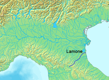
The Lamone is a river in the Tuscany and Emilia-Romagna regions of Italy.[1] The source of the river is in the Appennino Tosco-Emiliano mountains in the province of Florence. The river flows northeast near Marradi before crossing the border into the province of Ravenna. It continues flowing northeast near Brisighella, Faenza, Russi and Bagnacavallo before curving eastward north of Ravenna and entering the Adriatic Sea near Marina Romea and Marina di Ravenna.
References
^ The Times Comprehensive Atlas of the World (13 ed.). London: Times Books. 2011. p. 76 M6. ISBN 9780007419135..mw-parser-output cite.citationfont-style:inherit.mw-parser-output .citation qquotes:"""""""'""'".mw-parser-output .citation .cs1-lock-free abackground:url("//upload.wikimedia.org/wikipedia/commons/thumb/6/65/Lock-green.svg/9px-Lock-green.svg.png")no-repeat;background-position:right .1em center.mw-parser-output .citation .cs1-lock-limited a,.mw-parser-output .citation .cs1-lock-registration abackground:url("//upload.wikimedia.org/wikipedia/commons/thumb/d/d6/Lock-gray-alt-2.svg/9px-Lock-gray-alt-2.svg.png")no-repeat;background-position:right .1em center.mw-parser-output .citation .cs1-lock-subscription abackground:url("//upload.wikimedia.org/wikipedia/commons/thumb/a/aa/Lock-red-alt-2.svg/9px-Lock-red-alt-2.svg.png")no-repeat;background-position:right .1em center.mw-parser-output .cs1-subscription,.mw-parser-output .cs1-registrationcolor:#555.mw-parser-output .cs1-subscription span,.mw-parser-output .cs1-registration spanborder-bottom:1px dotted;cursor:help.mw-parser-output .cs1-ws-icon abackground:url("//upload.wikimedia.org/wikipedia/commons/thumb/4/4c/Wikisource-logo.svg/12px-Wikisource-logo.svg.png")no-repeat;background-position:right .1em center.mw-parser-output code.cs1-codecolor:inherit;background:inherit;border:inherit;padding:inherit.mw-parser-output .cs1-hidden-errordisplay:none;font-size:100%.mw-parser-output .cs1-visible-errorfont-size:100%.mw-parser-output .cs1-maintdisplay:none;color:#33aa33;margin-left:0.3em.mw-parser-output .cs1-subscription,.mw-parser-output .cs1-registration,.mw-parser-output .cs1-formatfont-size:95%.mw-parser-output .cs1-kern-left,.mw-parser-output .cs1-kern-wl-leftpadding-left:0.2em.mw-parser-output .cs1-kern-right,.mw-parser-output .cs1-kern-wl-rightpadding-right:0.2em
Coordinates: 44°31′N 12°17′E / 44.517°N 12.283°E / 44.517; 12.283
This Tuscany location article is a stub. You can help Wikipedia by expanding it. |
This article on a location in Emilia–Romagna is a stub. You can help Wikipedia by expanding it. |
This article related to a river in Italy is a stub. You can help Wikipedia by expanding it. |
