Oughtonhead Common
Oughtonhead Common is a 17.4 hectare Local Nature Reserve in the Westmill district of Hitchin, Hertfordshire. It is owned and managed by North Hertfordshire District Council.[1][2]
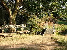
The River Oughton flows along the edge of the site, which has a wide variety of habitats. It is grazed by English Longhorn cattle, and there is a football pitch.[3] The Friends of Oughtonhead Common assist with maintaining the site.[4] It is part of the Chilterns Area of Outstanding Natural Beauty.[5]
| Wikimedia Commons has media related to Oughtonhead Common. |
References
^ "Oughtonhead Common". Local Nature Reserves. Natural England. 14 March 2013. Retrieved 8 February 2015..mw-parser-output cite.citationfont-style:inherit.mw-parser-output qquotes:"""""""'""'".mw-parser-output code.cs1-codecolor:inherit;background:inherit;border:inherit;padding:inherit.mw-parser-output .cs1-lock-free abackground:url("//upload.wikimedia.org/wikipedia/commons/thumb/6/65/Lock-green.svg/9px-Lock-green.svg.png")no-repeat;background-position:right .1em center.mw-parser-output .cs1-lock-limited a,.mw-parser-output .cs1-lock-registration abackground:url("//upload.wikimedia.org/wikipedia/commons/thumb/d/d6/Lock-gray-alt-2.svg/9px-Lock-gray-alt-2.svg.png")no-repeat;background-position:right .1em center.mw-parser-output .cs1-lock-subscription abackground:url("//upload.wikimedia.org/wikipedia/commons/thumb/a/aa/Lock-red-alt-2.svg/9px-Lock-red-alt-2.svg.png")no-repeat;background-position:right .1em center.mw-parser-output .cs1-subscription,.mw-parser-output .cs1-registrationcolor:#555.mw-parser-output .cs1-subscription span,.mw-parser-output .cs1-registration spanborder-bottom:1px dotted;cursor:help.mw-parser-output .cs1-hidden-errordisplay:none;font-size:100%.mw-parser-output .cs1-visible-errorfont-size:100%.mw-parser-output .cs1-subscription,.mw-parser-output .cs1-registration,.mw-parser-output .cs1-formatfont-size:95%.mw-parser-output .cs1-kern-left,.mw-parser-output .cs1-kern-wl-leftpadding-left:0.2em.mw-parser-output .cs1-kern-right,.mw-parser-output .cs1-kern-wl-rightpadding-right:0.2em
^ "Map of Oughtonhead Common". Local Nature Reserves. Natural England. Retrieved 8 February 2015.
^ "Oughtonhead Common". North Hertfordshire District Council. Archived from the original on 7 February 2015. Retrieved 8 February 2015.
^ "Oughtonhead Common leaflet" (PDF). North Hertfordshire District Council. Retrieved 8 February 2015.
^ "Oughtonhead Common". Chilterns Conservation Board. Retrieved 8 February 2015.
External links
- Oughtonhead Common, Countryside Management Service
Coordinates: 51°57′39″N 0°18′05″W / 51.9607°N 0.3015°W / 51.9607; -0.3015


