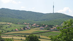
Zuce
Zuce Зуце | |
|---|---|
suburban settlement | |
 View on Avala from Zuce | |
| Country | |
| Population (2011) | |
| • Total | 2,001 |
| Time zone | UTC+1 (CET) |
| • Summer (DST) | UTC+2 (CEST) |
| Historical population | ||
|---|---|---|
| Year | Pop. | ±% |
| 1948 | 1,279 | — |
| 1953 | 1,380 | +7.9% |
| 1961 | 1,517 | +9.9% |
| 1971 | 1,526 | +0.6% |
| 1981 | 1,771 | +16.1% |
| 1991 | 1,967 | +11.1% |
| 2002 | 2,024 | +2.9% |
| 2011 | 2,001 | −1.1% |
| Source: [1] | ||
Zuce (Serbian Cyrillic: Зуце) is a suburban settlement of Belgrade, the capital of Serbia. It is located in Belgrade's municipality of Voždovac.
Contents
1 Location and geography
2 Population
3 Economy
4 References
Location and geography
Zuce is the easternmost settlement in the municipality, located in the low Šumadija region, on the eastern slopes of the Avala mountain in the valley of the Vranovac creek, a tributary to the Bolečica river. Zuce is located south-east of downtown Belgrade, next to the both railway and highway Belgrade-Niš. It generally spreads to the north (in the direction of the neighborhood of Bubanj Potok) and to the south (in the direction of Vrčin).
The area is known for several water springs, including the "Točak" (wheel) spring. In June 2008, a geothermal water spring (22 Celsius) was found in the alluvial valley of the Zavojnička river, on the depth of 150 meters.[2] Water is currently being tested by the Geology Institute of Serbia, which initially reported that the water, though not hot, might be used for heating via heating pumps which would warm it up.
Population
Zuce is statistically classified as a rural settlement (village). According to the official census of population it had 2,001 inhabitants in 2011. In 2002, Serbs made 96.89% and Goranci 0.84% of the population.
Economy
Zuce is an agricultural settlement. Major products are corn, wheat and, until 2010s, a quality cabbage. Many of the cabbage fields were sold in 2008 due to the construction of the Belgrade bypass. The village is also known for its young brined cheese ("mladi zučki sir"), from which the cream can not be skimmed.[3]
References
^ Comparative overview of the number of population in 1948, 1953, 1961, 1971, 1981, 1991, 2002 and 2011 – Data by settlements, page 29. Statistical Office of the Republic of Serbia, Belgrade. 2014. ISBN 978-86-6161-109-4..mw-parser-output cite.citationfont-style:inherit.mw-parser-output .citation qquotes:"""""""'""'".mw-parser-output .citation .cs1-lock-free abackground:url("//upload.wikimedia.org/wikipedia/commons/thumb/6/65/Lock-green.svg/9px-Lock-green.svg.png")no-repeat;background-position:right .1em center.mw-parser-output .citation .cs1-lock-limited a,.mw-parser-output .citation .cs1-lock-registration abackground:url("//upload.wikimedia.org/wikipedia/commons/thumb/d/d6/Lock-gray-alt-2.svg/9px-Lock-gray-alt-2.svg.png")no-repeat;background-position:right .1em center.mw-parser-output .citation .cs1-lock-subscription abackground:url("//upload.wikimedia.org/wikipedia/commons/thumb/a/aa/Lock-red-alt-2.svg/9px-Lock-red-alt-2.svg.png")no-repeat;background-position:right .1em center.mw-parser-output .cs1-subscription,.mw-parser-output .cs1-registrationcolor:#555.mw-parser-output .cs1-subscription span,.mw-parser-output .cs1-registration spanborder-bottom:1px dotted;cursor:help.mw-parser-output .cs1-ws-icon abackground:url("//upload.wikimedia.org/wikipedia/commons/thumb/4/4c/Wikisource-logo.svg/12px-Wikisource-logo.svg.png")no-repeat;background-position:right .1em center.mw-parser-output code.cs1-codecolor:inherit;background:inherit;border:inherit;padding:inherit.mw-parser-output .cs1-hidden-errordisplay:none;font-size:100%.mw-parser-output .cs1-visible-errorfont-size:100%.mw-parser-output .cs1-maintdisplay:none;color:#33aa33;margin-left:0.3em.mw-parser-output .cs1-subscription,.mw-parser-output .cs1-registration,.mw-parser-output .cs1-formatfont-size:95%.mw-parser-output .cs1-kern-left,.mw-parser-output .cs1-kern-wl-leftpadding-left:0.2em.mw-parser-output .cs1-kern-right,.mw-parser-output .cs1-kern-wl-rightpadding-right:0.2em
^ "Otkriven izvor termalne vode u Zucama". Politika (in Serbian). 2008-06-11. p. 26.
^ Dimitrije Bukvić (14 April 2013). "Ruralni Beograd - dve trećine prestonice" (in Serbian). Politika.
Coordinates: 44°41′58″N 20°33′20″E / 44.69944°N 20.55556°E / 44.69944; 20.55556
