Khotang District
Khotang District खोटाङ जिल्ला | |
|---|---|
District | |
 | |
| Country | Nepal |
| Province | Kirat State |
| Admin HQ. | Diktel |
| Government | |
| • Type | Coordination committee |
| • Body | DCC, Khotang |
| • Head | Mr. Babi Chamling |
| • Deputy-Head | Mrs. Goma Devi Khatri |
| • Parliamentary constituencies | 1 |
| • Provincial constituencies | 2 |
| Area | |
| • Total | 1,591 km2 (614 sq mi) |
| Population (2011 [1]) | |
| • Total | 206,312 |
| • Density | 130/km2 (340/sq mi) |
| Time zone | UTC+5:45 (NPT) |
| Website | ddckhotang.gov.np/en/ |
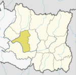
Khotang District (Nepali: खोटाङ जिल्ला![]() Listen (help·info)) is one of 14 districts of Kirat State of eastern Nepal. The district, with Diktel as its district headquarters, covers an area of 1,591 km² and has a population (2011) of 206,312.[1] Khotang is part of the area traditionally called Majh Kirat (middle Kirat /Khambuwan), home to indigenous ethnic Kirat Rai people. Apart from Rais, other ethnic groups and hill castes live in Khotang.Main languages Kirat Rai Chamling language or Kirat Rai languages and Khas Nepali.
Listen (help·info)) is one of 14 districts of Kirat State of eastern Nepal. The district, with Diktel as its district headquarters, covers an area of 1,591 km² and has a population (2011) of 206,312.[1] Khotang is part of the area traditionally called Majh Kirat (middle Kirat /Khambuwan), home to indigenous ethnic Kirat Rai people. Apart from Rais, other ethnic groups and hill castes live in Khotang.Main languages Kirat Rai Chamling language or Kirat Rai languages and Khas Nepali.
Geography and climate
Climate Zone[2] | Elevation Range | % of Area |
|---|---|---|
| Lower Tropical | below 300 meters (1,000 ft) | 0.7% |
| Upper Tropical | 300 to 1,000 meters 1,000 to 3,300 ft. | 31.5% |
Subtropical | 1,000 to 2,000 meters 3,300 to 6,600 ft. | 49.1% |
Temperate | 2,000 to 3,000 meters 6,400 to 9,800 ft. | 16.3% |
Subalpine | 3,000 to 4,000 meters 9,800 to 13,100 ft. | 1.6% |
Municipalities and Village Development Committees (VDC))

Map of the VDCs in Khotang District
- Ainselu Kharka
- Arkhale
- Badahare
- Badka Dipali
- Bahunidanda
- Bakachol
- Baksila
- Bamrang
- Barahapokhari
- Baspani
- Batase
- Bijaya Kharka
- Buipa
- Chhitapokhari
- Chhorambu
- Chipring
- Chisapani
- Chyandanda
- Chyasmitar
- Damarkhu Shivalaya
- Dandagaun
- Devisthan
- Dharapani
- Dhitung
- Diktel Municipality
- Dikuwa
- Diplung
- Dipsung
- Dorpa Chiuridanda
- Dubekol
- Dumre Dharapani
- Durchhim
- Hanchaur
- Indrayani Pokhari
- Jalapa
- Jyamire
- Kahalle
- Kaule
- Kharmi
- Kharpa
- Khartamchha
- Khidima
- Khotang Bazar
Kubhinde,- Laphyang
- Lamidanda
- Lichki Ramche
- Linkuwa Pokhari
- Magpa
- Mahadevasthan
- Mangaltar
- Mattim Birta
- Mauwabote
- Nerpa
- Nirmalidada
- Nunthala
- Patheka
- Pauwasera
- Phaktang
- Phedi
- Rajapani
- Rakha Bangdel
- Rakha Dipsung
- Ratancha Majhagaun
- Ribdung Jaleshwari
- Ribdung Maheshwari
- Salle
- Santeshwar Chhitapokhari
- Sapteshwar
- Saunechaur
- Sawakatahare
- Simpani
- Solma
- Sungdel
- Suntale
- Woplukha
- Wopung
- Yamkhya
References
^ ab Household and population by districts, Central Bureau of Statistics (CBS) Nepal Archived 2013-09-27 at the Wayback Machine
^
The Map of Potential Vegetation of Nepal - a forestry/agroecological/biodiversity classification system (PDF), . Forest & Landscape Development and Environment Series 2-2005 and CFC-TIS Document Series No.110., 2005, ISBN 87-7903-210-9, retrieved November 22, 2013.mw-parser-output cite.citationfont-style:inherit.mw-parser-output .citation qquotes:"""""""'""'".mw-parser-output .citation .cs1-lock-free abackground:url("//upload.wikimedia.org/wikipedia/commons/thumb/6/65/Lock-green.svg/9px-Lock-green.svg.png")no-repeat;background-position:right .1em center.mw-parser-output .citation .cs1-lock-limited a,.mw-parser-output .citation .cs1-lock-registration abackground:url("//upload.wikimedia.org/wikipedia/commons/thumb/d/d6/Lock-gray-alt-2.svg/9px-Lock-gray-alt-2.svg.png")no-repeat;background-position:right .1em center.mw-parser-output .citation .cs1-lock-subscription abackground:url("//upload.wikimedia.org/wikipedia/commons/thumb/a/aa/Lock-red-alt-2.svg/9px-Lock-red-alt-2.svg.png")no-repeat;background-position:right .1em center.mw-parser-output .cs1-subscription,.mw-parser-output .cs1-registrationcolor:#555.mw-parser-output .cs1-subscription span,.mw-parser-output .cs1-registration spanborder-bottom:1px dotted;cursor:help.mw-parser-output .cs1-ws-icon abackground:url("//upload.wikimedia.org/wikipedia/commons/thumb/4/4c/Wikisource-logo.svg/12px-Wikisource-logo.svg.png")no-repeat;background-position:right .1em center.mw-parser-output code.cs1-codecolor:inherit;background:inherit;border:inherit;padding:inherit.mw-parser-output .cs1-hidden-errordisplay:none;font-size:100%.mw-parser-output .cs1-visible-errorfont-size:100%.mw-parser-output .cs1-maintdisplay:none;color:#33aa33;margin-left:0.3em.mw-parser-output .cs1-subscription,.mw-parser-output .cs1-registration,.mw-parser-output .cs1-formatfont-size:95%.mw-parser-output .cs1-kern-left,.mw-parser-output .cs1-kern-wl-leftpadding-left:0.2em.mw-parser-output .cs1-kern-right,.mw-parser-output .cs1-kern-wl-rightpadding-right:0.2em
"Districts of Nepal". Statoids.
| Wikimedia Commons has media related to Khotang District. |
Places adjacent to Khotang District | ||||||||||
|---|---|---|---|---|---|---|---|---|---|---|
| ||||||||||
Khotang District | ||
|---|---|---|
Headquarter: Diktel | ||
Urban Municipality: 2 |
|  |
Rural Municipality:8 |
| |
For former VDCs See here | ||
Provinces and Districts of Nepal | ||
|---|---|---|
| Province No. 1 |
|  |
| Province No. 2 |
| |
| Province No. 3 |
| |
| Gandaki Pradesh |
| |
| Province No. 5 |
| |
| Karnali Pradesh |
| |
| Sudurpashchim Pradesh |
| |
Coordinates: 27°12′N 86°47′E / 27.200°N 86.783°E / 27.200; 86.783
This Nepalese location article is a stub. You can help Wikipedia by expanding it. |


