Serra de Sant Pere
| Serra de Sant Pere | |
|---|---|
| Serra del Solà | |
 | |
| Highest point | |
| Peak | Tossal de Sant Pere |
| Elevation | 541 m (1,775 ft) |
| Listing | Mountains of the Valencian Community |
| Coordinates | 40°32′25″N 0°16′11″E / 40.54028°N 0.26972°E / 40.54028; 0.26972Coordinates: 40°32′25″N 0°16′11″E / 40.54028°N 0.26972°E / 40.54028; 0.26972 |
| Geography | |
 Serra de Sant Pere Location in Spain | |
| Location | Baix Maestrat, Valencian Community |
| Parent range | Iberian System Eastern zone / Mediterranean System, Southern zone |
| Geology | |
| Orogeny | Alpine orogeny |
| Type of rock | Karstic |
| Climbing | |
| Easiest route | Straight to the Tossal de Sant Pere hiking from Traiguera or along the ridge from Canet lo Roig |
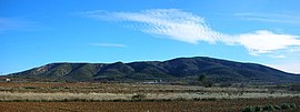
Serra de Sant Pere (Saint Peter's Range)[1] (Valencian pronunciation: [ˈsɛra ðe ˈsam ˈpeɾe], Spanish: Sierra del Solá) or Serra del Solà[2] is a 5.8 km (4 mi) long mountain range in the Baix Maestrat comarca, Valencian Community, Spain. Its highest point is Tossal de Sant Pere (541 m). The slopes are covered in low Mediterranean vegetation [3]
Contents
1 Location
2 See also
3 References
4 External links
Location
This moderately high mountain chain rises west of Traiguera and east of Canet lo Roig, in the transitional zone between the Mediterranean and the continental climate. It is part of the transitional area between the Iberian System and the Mediterranean System of mountains. Unlike the nearby Cervera Mountains, the summits are rarely covered in snow in the winter.[4]
There is a ruined church building formerly dedicated to Saint Peter the Apostle close to the top of the highest peak, as well as a cave with steps. Ancient Iberian remains and steles have been found in the lower slopes of the western side of the range.
Hiking paths are well marked and there is a triangulation pillar as well as a disused, rusting antenna on the highest summit.
See also
- Maestrat/Maestrazgo
- Mountains of the Valencian Community
References
^ Traiguera Archived 2010-10-03 at the Wayback Machine.
^ Vicenç M. Rosselló i Verger, Toponímia, geografia i cartografia
^ Flora de la Província de Castelló (in Spanish)
^ Benicarló: Terres Insospitades i Desconegudes del Maestrat Archived 2011-07-20 at the Wayback Machine.
External links
| Wikimedia Commons has media related to Serra de Sant Pere. |
- El País Valencià poble a poble; comarca a comarca - El Baix Maestrat
- José Quereda Sala, Les Moles de Xert,; Análisis Geomorfológico
- El nom de Canet
- Toll Negre - Flora
- Ramaderia


