Prijepolje
Prijepolje Пријепоље | |
|---|---|
Town and municipality | |
   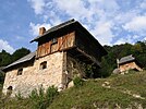  From top: Prijepolje Old Town, Monument to St. Sava, Prijepolje Clock tower, Old mills on waterfall Sopotnica, Mileševa monastery | |
 Coat of arms | |
 Location of the municipality of Prijepolje within Serbia | |
| Coordinates: 43°23′N 19°38′E / 43.383°N 19.633°E / 43.383; 19.633Coordinates: 43°23′N 19°38′E / 43.383°N 19.633°E / 43.383; 19.633 | |
| Country | |
| Region | Šumadija and Western Serbia |
| District | Zlatibor |
| First time mentioned | 7 July 1343 (1343-07-07) |
| Settlements | 96 |
| Government | |
| • Mayor | Dragoljub Zindović (SNS) |
| Area [1] | |
| • Town | 9.67 km2 (3.73 sq mi) |
| • Municipality | 827 km2 (319 sq mi) |
| Elevation | 557 m (1,827 ft) |
| Highest elevation | 1,734 m (5,689 ft) |
| Lowest elevation | 440 m (1,440 ft) |
| Population (2011 census)[2] | |
| • Town | 13,330 |
| • Town density | 1,400/km2 (3,600/sq mi) |
| • Municipality | 37,059 |
| • Municipality density | 45/km2 (120/sq mi) |
| Time zone | UTC+1 (CET) |
| • Summer (DST) | UTC+2 (CEST) |
| Postal code | 31300 |
| Area code | +381(0)33 |
| Car plates | PP |
| Website | www.opstinaprijepolje.rs |
Prijepolje (Serbian Cyrillic: Пријепоље, pronounced [prijěːpoʎe]) is a town and municipality located in the Zlatibor District of southwestern Serbia. As of 2011 census, the town has 13,330 inhabitants, while the municipality has 37,059 inhabitants.
Contents
1 Etymology
2 Geography
2.1 Climate
3 History
4 Settlements
5 Demographics
5.1 Ethnic groups
6 Economy
7 Culture and tourism
8 Society
8.1 Education
8.2 Sport
8.3 Media
8.4 Events
8.5 Activism and youth
8.6 Night life
9 Gallery
10 Coat of arms
11 Notable people
12 International relations
12.1 Twin towns — sister cities
13 See also
14 References
15 External links
Etymology
One possible meaning of the name Prijepolje is "Prija's field", where Prija is the owner of polje, the "field" in English. However, a more likely theory is that the name originates from the location of Prijepolje and its relationship to the travels of caravans. When those caravans were passing through the area which would become Prijepolje, they would arrive at the settlement "before the fields", where the present day neighborhoods of Ivanje and Velika Župa are located. "Prije" means "before", and "polje" means "field", hence, the location might be called Prijepolje.[3][citation needed]
Geography
Prijepolje is located at the confluence of the fast-flowing Lim and Mileševka rivers. It is also situated along the road from Belgrade to the Adriatic sea, as well as being a stop on the Belgrade – Bar railway. The Belgrade – Adriatic road intersects here with the regional road between Pljevlja, Prijepolje and Sjenica. This regional road follows roughly the same route as the ancient Roman and Ottoman road known as the Dubrovnik road. Just north of Prijepolje, at Bistrica, there is a road leading towards Priboj, Višegrad and Sarajevo. Prijepolje is surrounded by hills, such as Pušina, Srijeteži, Gradina and Sokolica, which, prior to the construction of the "Potpeć" hydro plant near Nova Varoš, created a unique climate around the municipality. Since the hydro plant's construction, Prijepolje's climate has been changed into one that is typical for this cold part of Serbia. The highest peak in the Prijepolje area is Katunić, which reaches 1,734 meters above sea level.
Forests surround most of Prijepolje, however, along the Lim, there are numerous beaches. Two of the most popular beaches are under bridges, one at the centre of the town, under the bridge in Ivanje, and another under the bridge in Petrovac.[4]
Climate
Prijepolje has a humid continental climate (Köppen climate classification: Dfb), that's very close to an oceanic climate (Köppen climate classification: Cfb).
| Climate data for Prijepolje | |||||||||||||
|---|---|---|---|---|---|---|---|---|---|---|---|---|---|
| Month | Jan | Feb | Mar | Apr | May | Jun | Jul | Aug | Sep | Oct | Nov | Dec | Year |
| Average high °C (°F) | 3.8 (38.8) | 6.7 (44.1) | 11.8 (53.2) | 15.6 (60.1) | 20.5 (68.9) | 24.0 (75.2) | 26.6 (79.9) | 26.9 (80.4) | 23.3 (73.9) | 17.6 (63.7) | 10.0 (50.0) | 5.3 (41.5) | 16.0 (60.8) |
| Daily mean °C (°F) | 0.0 (32.0) | 2.4 (36.3) | 6.7 (44.1) | 10.3 (50.5) | 14.8 (58.6) | 18.2 (64.8) | 20.3 (68.5) | 20.4 (68.7) | 17.0 (62.6) | 12.1 (53.8) | 6.0 (42.8) | 1.9 (35.4) | 10.8 (51.5) |
| Average low °C (°F) | −3.7 (25.3) | −1.9 (28.6) | 1.6 (34.9) | 5.0 (41.0) | 9.2 (48.6) | 12.5 (54.5) | 14.1 (57.4) | 13.9 (57.0) | 10.7 (51.3) | 6.7 (44.1) | 2.0 (35.6) | −1.5 (29.3) | 5.7 (42.3) |
| Average precipitation mm (inches) | 89 (3.5) | 81 (3.2) | 79 (3.1) | 88 (3.5) | 96 (3.8) | 87 (3.4) | 73 (2.9) | 69 (2.7) | 85 (3.3) | 97 (3.8) | 115 (4.5) | 106 (4.2) | 1,065 (41.9) |
| Source: Climate-Data.org [5] | |||||||||||||
History
Prijepolje was established as a settlement in 1234, the same year the Mileševa Monastery was built. Prior to its establishment as a settlement, the area was occupied as far back as the stone age. First settled by Illyrians, who migrated to the area after being forced out of the northern plains, they retreated to the more defensible and less accessible mountainous regions. Later arrivals were the Celts, with whom the Illyrians intermarried. With the arrival by the Romans, the Illyrians were again forced to flee, and after the Romans, the Slavs settled in the area, intermixing with some of the earlier Illyrians. The Goths, Huns, Gepids, Langobards and Avars also passed through this area. The most interesting archaeological site in the territory is the Roman necropolis near the modern settlement of Kolovrat where pieces of ancient glass, silver, ceramics, and gold have been unearthed.
Prijepolje was mentioned for the first time by Gijom Adam in 1332 while it was part of Dubrovnik's sphere of influence. According to historical sources, Prijepolje developed as a road settlement for caravans along the route known as "Dubrovnik's road", a road connecting the central and eastern Balkans with the middle Adriatic coast. The caravan route traversed both mountainous and heavily forested areas, which could prove dangerous to travelers. Local villagers were tasked with protecting local roads, due to the statute which said, "If, on the road, someone has been killed or has had a bullet stuck into his body, let the local guardians gather together to pay the damage. Hitting by one small drum, the passers by would know that there was no danger". On 26 October 1377, Tvrtko I was crowned as the king of the Serbs, Bosnia and the Seaside and the Western Lands, in the monastery of Mileševa.
After the reference to Tvrtko's coronation in Mileševa, there was a cartographic reference to Prijepolje in "Regno della Servia detta altrimentri Rascia" by Giacomo Cantelli da Vignola, cartographer to the Duke of Modena, in 1689.
During the Ottoman period, there were quite a few buildings constructed in Prijepolje. Most famous of these are Ibrahim Pasha's mosque and the Sahat Kula. Pasha's mosque is located in Šarampov, one of three regions in town (the other two being Vakuf and the Town Center), and was most likely built in the 16th century. It is adorned with a single minaret, and covered by a "cheramida" (a special covering of the houses in that time). The region has a very tumultuous past. It was part of First Serbian revolt in 1875, known as Banine's revolt, as well as seeing the Javorian War in 1876, the Raonić Revolt, the Balkan Wars in 1912 and 1913, and both World Wars.[6] In 1912, during the First Balkan War, control of Prijepolje passed from the Ottoman Empire to the Kingdom of Montenegro.
During World War II, Prijepolje officially became part of the Kingdom of Montenegro, a pro-Axis puppet state. Prijepolje was liberated on 4 December 1943, which is now celebrated as the Day of the Liberation of Prijepolje.[7]

The town of Prijepolje - center of Prijepolje municipality.

Panorama of Prijepolje and the Lim river in the winter.
Settlements
The municipality of Prijepolje covers an area of 824 km2 (318 sq mi) with an altitude ranging from 440–1,735 metres (1,444–5,692 ft). Not including the town of Prijepolje itself, it contains 96 other settlements.[8] Those settlements are as follows, with population figures according to the 2002 census:
Aljinovići (196)
Balići (434)
Bare (56)
Biskupići (22)
Bjelahova (82)
Brajkovac (87)
Brodarevo (1780)
Brvine (175)
Bukovik (107)
Čadinje (267)
Čauševići (132)
Crkveni Toci (78)
Divci (335)
Donje Babine (319)
Donji Stranjani (120)
Drenova (208)
Đurašići (265)
Dušmanići (245)
Džurovo (179)
Gojakovići (183)
Gornje Babine (262)
Gornje Goračiće (58)
Gornji Stranjani (85)
Gostun (49)
Gračanica (199)
Grobnice (254)
Hisardžik (285)
Hrta (130)
Ivanje (1140)
Ivezići (170)
Izbičanj (46)
Jabuka (502)
Junčevići (301)
Kaćevo (55)
Kamena Gora (210)
Karaula (63)
Karoševina (199)
Kašice (88)
Koprivna (49)
Kosatica (353)
Koševine (1049)
Kovačevac (1613)
Kruševo (36)
Kučin (169)
Ljiljci (46)
Lučice (169)
Mataruge (164)
Međani (80)
Mijani (25)
Mijoska (750)
Milakovići (66)
Mileševo (121)
Miljevići (455)
Milošev Do (126)
Mrčkovina (33)
Muškovina (34)
Oraovac (336)
Orašac (204)
Osoje (526)
Oštra Stijena (123)
Potkrš (124)
Potok (282)
Pranjci (360)
Pravoševo (85)
Rasno (410)
Ratajska (2088)
Sedobro (322)
Seljane (168)
Seljašnica (774)
Skokuće (105)
Slatina (138)
Sopotnica (136)
Taševo (2061)
Vinicka (474)- Velika Zupa
Vrbovo (99)
Zabrdnji Toci (133)
Zalug (1047)
Zastup (128)
Zavinograđe (1272)
Zvijezd (104)
Demographics
| Historical population | ||
|---|---|---|
| Year | Pop. | ±% p.a. |
| 1948 | 31,328 | — |
| 1953 | 35,568 | +2.57% |
| 1961 | 38,925 | +1.13% |
| 1971 | 44,022 | +1.24% |
| 1981 | 46,902 | +0.64% |
| 1991 | 46,525 | −0.08% |
| 2002 | 41,188 | −1.10% |
| 2011 | 37,059 | −1.17% |
| Source: [9] | ||
According to the last official census done in 2011, the Municipality of Prijepolje has 37,059 inhabitants, and 64.0% of the municipality's population is rural.
Ethnic groups
In 1991, the majority of the population of the municipality was composed of Serbs (54.78%) and Muslims (43.42%). By 2002, the population of the municipality had shifted to mostly Serbs (23,402) and Bosniaks (13,109), with Muslims now representing the third largest segment with 3,812. A reason for this is that a large portion of those who in 1991 declared themselves as Muslims, now declared themselves as Bosniaks.
In 2011, the two largest groups were Serbs (52.6%) and Bosniaks (34.5%), followed by Muslims by nationality (9.6%), therefore in line with pre-1991 balances.
The ethnic composition of the municipality:[10]
| Ethnic group | Population |
|---|---|
| Serbs | 19,496 |
| Bosniaks | 12,792 |
| Muslims | 3,543 |
| Yugoslavs | 47 |
| Others | 1,181 |
| Total | 37,059 |
Economy
The following table gives a preview of total number of employed people per their core activity (as of 2016):[11]
| Activity | Total |
|---|---|
| Agriculture, forestry and fishing | 155 |
| Mining | 4 |
| Processing industry | 1,722 |
| Distribution of power, gas and water | 66 |
| Distribution of water and water waste management | 93 |
| Construction | 458 |
| Wholesale and retail, repair | 1,136 |
| Traffic, storage and communication | 639 |
| Hotels and restaurants | 294 |
| Media and telecommunications | 41 |
| Finance and insurance | 67 |
| Property stock and charter | 16 |
| Professional, scientific, innovative and technical activities | 190 |
| Administrative and other services | 159 |
| Administration and social assurance | 668 |
| Education | 554 |
| Healthcare and social work | 637 |
| Art, leisure and recreation | 102 |
| Other services | 133 |
| Total | 7,135 |
Culture and tourism

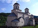
Mileševa monastery

Prijepolje's sahat-kula (Clock tower)
Prijepolje has many historical monuments from both the periods of Christianity and Islam. The Mileševa monastery is located 6 km to the east of Prijepolje on the Mileševka River. The monastery is famous for The White Angel fresco, a famous and widely used religious icon in Serbia as well as being the former resting place of St. Sava, Serbia's most honored patriarch.
A famous monument from the Turkish period, the Sahat-Kula, is in town, as well as several mosques, one of which is in Hisardžik, interesting because of a four-hundred-year-old wooden Quran which was recently unearthed. Jusovića's kula tower, built in the 18th century as a protective house tower for the wealthy. Currently in ruins, there are plans being made to reconstruct this building, adding another unique monument to Prijepolje.
The Museum of Prijepolje is a very significant part of the cultural life of Prijepolje. It serves as a gathering place for artists from diverse locations to visit Prijepolje, and corroborate on large projects to improve the town's culture. In addition to the Museum, there is also another major cultural building in Prijepolje, where amateurs, led by Meša Šendelj, are very active in refreshing the cultural life in Prijepolje.[12]
Society
Education
There are 2 kindergartens and one elementary school in town. Prijepolje also has a Gymnasium, a technical high school, an economics high school, and a higher technical school.
Sport
In Prijepolje there are many forms of recreation. There is the local football club "FK Polimlje", as well as "FK Jasen" from nearby Brodarevo (also in the municipality of Prijepolje). There are volleyball clubs like "FAP-Livnica" and "Putevi", a handball club "White angel", and a chess club "Priko". Many parks and playfields are in and around town. Traditionally every year during MOSI (an annual regional sporting event), both the male and female volleyball teams representing Prijepolje see great success. Ilija Andrejic, an alpinist from Prijepolje, together with the Serbian alpinist team, successfully climbed Mount Everest.
- On 14 of July, Prijepolje was the host of the European coupe in rafting on the Lim River.[when?]
- On 22 of September 2007, Vlade Divac, came to Prijepolje, with a group of NBA basketball players, and opened the newly built museum building.
Besides basketball player Vlade Divac and numerous volleyball man and woman players, other notable sportspeople from Prijepolje are footballers Spaso Perić, Muhamed Preljević, Latif Čičić, Mirsad Kahrović, Ljubomir Brašnjević, Husein Mekić, Mihajlo Pjanović, Ivica Dragutinović, while Dragoslav Divac, Siniša Nestorović, Stevo Ljujić and Vule Maksimović archived notability in athletics.[13]
Media
There is one weekly newspaper published in Prijepolje, Polimlje, and three radio stations. There is also one media civic station working from 2008 called Television Forum, operated by NGO Women forum of Prijepolje. There are two wireless internet operators, one TV cable operator, and two private TV and radio stations. Prijepolje got digital telephonic central since May 2003.

Flyer from REFRACT festival in Prijepolje
Events
- "Sopotnički izvori", is held near the famous Sopotnica's waterfalls, where you can hear old national songs.[when?]
- A famous diving demonstration is held at Petrovac, consisting of highly ranked divers from the Balkan region.[when?]
- There is a famous art colony called Mileševa, consisting of many artists from this municipality.
- "Gifts from Lim", is a sports and entertainment event where you can see diverse activities such as beach volleyball, a fish-soup making contest, and Prijepolje's Best son-in-law contest.[when?]
Activism and youth
There are 29 registered non-governmental organisations in Prijepolje, the most active ones being Jump, Helium, New Vision, Scout's "Boško Buha", Friends of Brodarevo, Friends of Sopotnica and Friends of Kamena Gora. Prijepolje has the first civic television program in Serbia run by a women's organization, the Woman Forum.
Prijepolje opened a Youth Club, under the auspices of National Strategy for Youth, and the Youth office of municipality Prijepolje was created in April 2008. The Youth Office's priority is to care for the rights and wills of the youth of the area, through constant youth work using the goals of local and national development organizations.
Night life
The night life in Prijepolje consists of cafes & night clubs. There is also a yearly regional festival called "Refract", highlighting many different cultural options. A new rock festival has recently begun in Prijepolje, gathering rock bands from the local region.
In 2005, the city hosted a Glaswegian Band, Quinn. The following year, in December 2006, one of the superstars of Serbian hip hop, Marčelo, held a concert in Prijepolje.
Gallery

Prijepolje in winter

The river Lim

Footballers of FK Polimlje celebrating a goal.

Mileševac fortrerss

Lim flowing through Prijepolje in the winter.

Mileševka river in Prijepolje.

Confluence of Mileševka river in the Lim.


Coat of arms
The coat of arms of Prijepolje depicts the mountain Zlatar (zlat from the word zlato which means gold in Serbian), the golden "pyramid of Zlatar", the sign of Saint Sava and two crowns which symbolize the two coronations which took place in Prijepolje. The more famous coronation was that of the King of Bosnia and the Serbs, Tvrtko I. Also on the coat of arms are two white angels from a fresco located in the monastery of Mileševa. The angels are holding the flags of Serbia, and Prijepolje. The curved line represents the Lim River.
Notable people
Valter Perić, World War II Partisan
Sreten Vukosavljević, minister in 1944. first Yugoslav government, sociologist, journalist, political active for decentralization of Sanjak region as unified region
Savatije Sokolović, Serbian Patriarch
Vlade Divac, former NBA player, two-time Olympic silver medalist, World and European champion- Svetomir Borisavljevic, member of parliament of Yugoslavia before Word War II, lawyer
Dženan Lončarević , pop singer
Aco Pejović, pop-folk singer
Zvonimir Červenko, Croatian General
Sefer Halilović, Bosnian Army general and politician
Ivica Dragutinović, footballer
Mihajlo Pjanović, footballer
Muhamed Preljević,footballer
Nemanja Petrić, volleyball player
Slobodan Morača, professor na Fakultetu tehničkih nauka u Novom Sadu
International relations
Twin towns — sister cities
Prijepolje is twinned with:
 Köniz
Köniz Eyüp
Eyüp Aranđelovac
See also
- Bosniaks of Serbia
- Lim River
- Zlatibor District
- List of places in Serbia
- Sandžak
References
^ "Municipalities of Serbia, 2006". Statistical Office of Serbia. Retrieved 2010-11-28..mw-parser-output cite.citationfont-style:inherit.mw-parser-output .citation qquotes:"""""""'""'".mw-parser-output .citation .cs1-lock-free abackground:url("//upload.wikimedia.org/wikipedia/commons/thumb/6/65/Lock-green.svg/9px-Lock-green.svg.png")no-repeat;background-position:right .1em center.mw-parser-output .citation .cs1-lock-limited a,.mw-parser-output .citation .cs1-lock-registration abackground:url("//upload.wikimedia.org/wikipedia/commons/thumb/d/d6/Lock-gray-alt-2.svg/9px-Lock-gray-alt-2.svg.png")no-repeat;background-position:right .1em center.mw-parser-output .citation .cs1-lock-subscription abackground:url("//upload.wikimedia.org/wikipedia/commons/thumb/a/aa/Lock-red-alt-2.svg/9px-Lock-red-alt-2.svg.png")no-repeat;background-position:right .1em center.mw-parser-output .cs1-subscription,.mw-parser-output .cs1-registrationcolor:#555.mw-parser-output .cs1-subscription span,.mw-parser-output .cs1-registration spanborder-bottom:1px dotted;cursor:help.mw-parser-output .cs1-ws-icon abackground:url("//upload.wikimedia.org/wikipedia/commons/thumb/4/4c/Wikisource-logo.svg/12px-Wikisource-logo.svg.png")no-repeat;background-position:right .1em center.mw-parser-output code.cs1-codecolor:inherit;background:inherit;border:inherit;padding:inherit.mw-parser-output .cs1-hidden-errordisplay:none;font-size:100%.mw-parser-output .cs1-visible-errorfont-size:100%.mw-parser-output .cs1-maintdisplay:none;color:#33aa33;margin-left:0.3em.mw-parser-output .cs1-subscription,.mw-parser-output .cs1-registration,.mw-parser-output .cs1-formatfont-size:95%.mw-parser-output .cs1-kern-left,.mw-parser-output .cs1-kern-wl-leftpadding-left:0.2em.mw-parser-output .cs1-kern-right,.mw-parser-output .cs1-kern-wl-rightpadding-right:0.2em
^ "2011 Census of Population, Households and Dwellings in the Republic of Serbia: Comparative Overview of the Number of Population in 1948, 1953, 1961, 1971, 1981, 1991, 2002 and 2011, Data by settlements" (PDF). Statistical Office of Republic Of Serbia, Belgrade. 2014. ISBN 978-86-6161-109-4. Retrieved 2014-06-27.
^ Milinko Femić, Prijepoljski kraj u prostoru i vremenu
^ Milinko Femić, Prijepoljski kraj u prostoru i vremenu
^ "Climate: Prijepolje, Serbia". Climate-Data.org. Retrieved 16 February 2018.
^ Milinko Femić: "Prijepoljski kraj u prostoru i vremenu"
^ Milinko Femić, Prijepoljski kraj u prostoru i vremenu
^ "2011 Census of Population, Households and Dwellings in the Republic of Serbia: Comparative Overview of the Number of Population in 1948, 1953, 1961, 1971, 1981, 1991, 2002 and 2011, Data by settlements" (PDF). Statistical Office of Republic Of Serbia, Belgrade. 2014. ISBN 978-86-6161-109-4. Retrieved 2014-06-27.
^ "2011 Census of Population, Households and Dwellings in the Republic of Serbia" (PDF). stat.gov.rs. Statistical Office of the Republic of Serbia. Retrieved 11 January 2017.
^ "Попис становништва, домаћинстава и станова 2011. у Републици Србији" (PDF). stat.gov.rs. Republički zavod za statistiku. Retrieved 15 December 2016.
^ "ОПШТИНЕ И РЕГИОНИ У РЕПУБЛИЦИ СРБИЈИ, 2017" (PDF). stat.gov.rs (in Serbian). Statistical Office of the Republic of Serbia. Retrieved 20 February 2018.
^ Milinko Femić, Prijepoljski kraj u prostoru i vremenu
^ Monografija FK Polimlje 1920-2010, Siniša Nestorović, page 12 (in Serbian)
External links
| Wikimedia Commons has media related to Prijepolje. |
| Wikivoyage has a travel guide for Prijepolje. |
- Official website
Municipalities and cities of Serbia | ||||||||||||
|---|---|---|---|---|---|---|---|---|---|---|---|---|
| ||||||||||||
| ||||||||||||
| ||||||||||||
| ||||||||||||
| ||||||||||||


