St. James's Park tube station
| St. James's Park | |
|---|---|
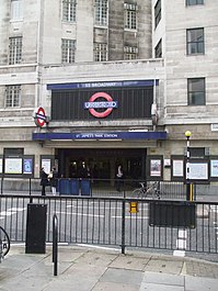 Entrance from Petty France | |
 St. James's Park Location of St. James's Park in Central London | |
| Location | St. James's Park |
| Local authority | City of Westminster |
| Managed by | London Underground |
| Number of platforms | 2 |
| Fare zone | 1 |
| London Underground annual entry and exit | |
| 2013 | |
| 2014 | |
| 2015 | |
| 2016 | |
| 2017 | |
| Key dates | |
| 1868 | Opened (DR) |
| 1872 | Started "Outer Circle" (NLR) |
| 1872 | Started "Middle Circle" (H&CR/DR) |
| 1900 | Ended "Middle Circle" |
| 1908 | Ended "Outer Circle" |
| 1949 | Started (Circle line) |
Listed status | |
| Listing grade | I |
| Entry number | 1219790[2] |
| Added to list | 9 January 1970 |
| Other information | |
| Lists of stations |
|
| External links |
|
| WGS84 | 51°29′58″N 0°08′04″W / 51.4994°N 0.1344°W / 51.4994; -0.1344Coordinates: 51°29′58″N 0°08′04″W / 51.4994°N 0.1344°W / 51.4994; -0.1344 |
St. James's Park is a London Underground station near St. James's Park in the City of Westminster, central London. It is served by the District and Circle lines and is between Victoria and Westminster stations. It is in Travelcard Zone 1.
The station building is incorporated into 55 Broadway, the headquarters of Transport for London, and has entrances from Broadway, Petty France and Palmer Street. The station is close to New Scotland Yard and several government offices. The station is not wheelchair accessible.
Contents
1 History
2 Name
3 Gallery
4 Connections
5 References
6 External links
History
The station was opened on 24 December 1868 by the District Railway (DR, now the District line) when the company opened the first section of its line between South Kensington and Westminster stations. The DR connected to the Metropolitan Railway (MR, later the Metropolitan line) at South Kensington and, although the two companies were rivals, each company operated its trains over the other's tracks in a joint service known as the "Inner Circle".
On 1 February 1872, the DR opened a northbound branch from its station at Earl's Court to connect to the West London Extension Joint Railway (WLEJR, now the West London Line) which it connected to at Addison Road (now Kensington (Olympia)). From that date the "Outer Circle" service began running over the DR's tracks. The service was run by the North London Railway (NLR) from its terminus at Broad Street (now demolished) close to Liverpool Street station in the City of London via the North London Line to Willesden Junction, then the West London Line to Addison Road and the DR to Mansion House, the new eastern terminus of the DR.
From 1 August 1872, the "Middle Circle" service also began operations through St. James's Park running from Moorgate along the MR's tracks on the north side of the Inner Circle to Paddington then over the Hammersmith & City Railway (H&CR) track to Latimer Road then, via a now demolished link, to the West London Line to Addison Road and the DR to Mansion House. The service was operated jointly by the H&CR and the DR.
On 30 June 1900, the Middle Circle service was withdrawn between Earl's Court and Mansion House. On 31 December 1908 the Outer Circle service was also withdrawn.

Entrance on Broadway
The station has been reconstructed twice. In the first decade of the 20th century the original DR station was reconstructed in conjunction with the building of Electric Railway House a headquarters building for the DR's owners the London Electric Railway. The station was then rebuilt again between 1927 and 1929 as part of the construction of 55 Broadway the company's new headquarters building designed by Charles Holden and featuring statues and carved stone panels including ones by Sir Jacob Epstein, Eric Gill, and Henry Moore.
The platforms feature the green, blue, black and white tiling scheme first used for the reconstruction and extension to Morden of the City & South London Railway (now the Northern line) also designed by Holden and opened between 1924 and 1926.
In 1949, the Metropolitan line operated Inner Circle route was given its own identity on the tube map as the Circle line.
The separate Palmer Street entrance and booking hall were rebuilt as part of a further redevelopment in the 1960s.
Together with 55 Broadway, the station is a Grade I listed building.[3]
Name
Over time, the station name has been spelt differently, illustrating changing practice in punctuation. Tube maps up to the early 1930s show the name as "St. James' Park". From Harry Beck's first map in 1933 until the early 1950s the name was shown as "St. James Park". Since 1951 it has had the current name.[4][5]
Originally installed in the late 1920s when the first version of the name was in use, the station name displayed in the platform roundels exhibit modification to account for this change. One of the roundels on the eastbound platform still reads "St. James' Park", the rest have had new name plates affixed giving the current spelling and punctuation, "St. James's Park".
Gallery
| Wikimedia Commons has media related to St. James's Park tube station. |

Interior

Platforms looking clockwise/westbound

Platforms looking anticlockwise/eastbound
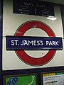
Platform roundel

Western entrance on Palmer Street


Connections
London Buses routes 11, 24, 148, 211 and 507 and night routes N2, N11, N44, N52 and N136 serve the station.
References
^ abcde "Multi-year station entry-and-exit figures" (XLSX). London Underground station passenger usage data. Transport for London. January 2018. Retrieved 22 July 2018..mw-parser-output cite.citationfont-style:inherit.mw-parser-output qquotes:"""""""'""'".mw-parser-output code.cs1-codecolor:inherit;background:inherit;border:inherit;padding:inherit.mw-parser-output .cs1-lock-free abackground:url("//upload.wikimedia.org/wikipedia/commons/thumb/6/65/Lock-green.svg/9px-Lock-green.svg.png")no-repeat;background-position:right .1em center.mw-parser-output .cs1-lock-limited a,.mw-parser-output .cs1-lock-registration abackground:url("//upload.wikimedia.org/wikipedia/commons/thumb/d/d6/Lock-gray-alt-2.svg/9px-Lock-gray-alt-2.svg.png")no-repeat;background-position:right .1em center.mw-parser-output .cs1-lock-subscription abackground:url("//upload.wikimedia.org/wikipedia/commons/thumb/a/aa/Lock-red-alt-2.svg/9px-Lock-red-alt-2.svg.png")no-repeat;background-position:right .1em center.mw-parser-output .cs1-subscription,.mw-parser-output .cs1-registrationcolor:#555.mw-parser-output .cs1-subscription span,.mw-parser-output .cs1-registration spanborder-bottom:1px dotted;cursor:help.mw-parser-output .cs1-hidden-errordisplay:none;font-size:100%.mw-parser-output .cs1-visible-errorfont-size:100%.mw-parser-output .cs1-subscription,.mw-parser-output .cs1-registration,.mw-parser-output .cs1-formatfont-size:95%.mw-parser-output .cs1-kern-left,.mw-parser-output .cs1-kern-wl-leftpadding-left:0.2em.mw-parser-output .cs1-kern-right,.mw-parser-output .cs1-kern-wl-rightpadding-right:0.2em
^ Historic England. "Details from listed building database (1219790)". National Heritage List for England. Retrieved 14 November 2012.
^ "St James's Park station gets Grade I listing". Department of Culture, Media and Sport. 12 January 2011. Retrieved 14 January 2011.
^ Badsey-Ellis, Antony (November 2008). "The Underground and the apostrophe" (PDF). Underground News. London Underground Railway Society. Retrieved 21 February 2014.
^ "A History of the London Tube Maps". Retrieved 2008-09-04.
External links
London Transport Museum Photographic Archive- Newly built Petty France entrance with Electric Railway House above, 1910
- Palmer Street entrance, 1916
- Petty France entrance, 1922
- Broadway Entrance, 1929
- Booking hall, 1932
- Petty France entrance, 1935
- Corner entrance to 55 Broadway, originally entrance to offices only, 1949
- Internal circulation area, 1953
- Palmer Street entrance, 1966
- More photographs of St. James's Park station
| Preceding station | | | Following station | |
|---|---|---|---|---|
Victoria towards Edgware Road | Circle line | Westminster towards Hammersmith (via Tower Hill) | ||
Victoria towards Wimbledon, Richmond or Ealing Broadway | District line | Westminster towards Upminster |
Circle line | |||||||
|---|---|---|---|---|---|---|---|
| Stations |
| ||||||
| Rolling stock |
| ||||||
| History |
| ||||||
| See also |
| ||||||
| |||||||
District line | |||||||||||
|---|---|---|---|---|---|---|---|---|---|---|---|
| Stations |
| ||||||||||
| Rolling stock |
| ||||||||||
| History |
| ||||||||||
| Depots |
| ||||||||||
| See also |
| ||||||||||
| |||||||||||


