Pontsticill Reservoir
| Pontsticill Reservoir | |
|---|---|
 | |
| Location | Taf Fechan |
| Coordinates | 51°48′56″N 3°22′17″W / 51.81556°N 3.37139°W / 51.81556; -3.37139Coordinates: 51°48′56″N 3°22′17″W / 51.81556°N 3.37139°W / 51.81556; -3.37139 |
| Lake type | reservoir |
Basin countries | United Kingdom |
| Surface area | 102 ha (250 acres) |
| Max. depth | 30 m (98 ft) |
| Surface elevation | 330 m (1,080 ft) |
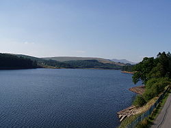
Pontsticill Reservoir (Welsh: Cronfa Pontsticill) or Taf Fechan Reservoir is a large reservoir on the Taf Fechan lying partly in the county of Powys and partly within the county borough of Merthyr Tydfil in south Wales. It lies within the Brecon Beacons National Park and Fforest Fawr Geopark.[1]

Bell-mouth spillway and valve tower
The 110 ft high embankment has, since its completion in 1927, been holding back 3400 million gallons of water for supply to industry and population to the south. The modern reservoir incorporates the earlier Pentwyn Reservoir (sometimes referred to as Dol-y-gaer Reservoir or Lake) which suffered major water losses after completion due to the presence of major fractures in the bedrock beneath its dam relating to the Neath Disturbance, a major geological fault which runs northeast to southwest through the area.[2]
The reservoir is popular with sailors, anglers and picnickers. The Taff Trail has been developed for walkers and cyclists and runs through the woods on the western side of the Reservoir. Merthyr Tydfil sailing club is based on the eastern bank and the Brecon Mountain Railway which runs up its eastern side from Pant Station to Dolygaer and on to Torpantau, the line's summit, since 1 April 2014. This steam railway runs on the route of the former Brecon and Merthyr Railway.
Most of the banks of the reservoir have been heavily afforested by Welsh Water though management of these woods is undertaken by the Natural Resources Wales on behalf of the company.
Part of the 2011 film Submarine was filmed on the reservoir walkway.
References
^ Ordnance Survey Explorer map OL12 'Brecon Beacons National Park: western area'
^ ‘Reservoir Builders of South Wales’ (Dam Builders in the Age of Steam series book six) Bowtell H.D. & Hill G.
External links
| Wikimedia Commons has media related to Pontsticill Reservoir. |
- Images of Pontsticill Reservoir and surrounding area on the Geograph website
- The Merthyr Tydfil Sailing Club website
- The Merthyr Tydfil Angling Association website


