Briercliffe
| Briercliffe with Extwistle | |
|---|---|
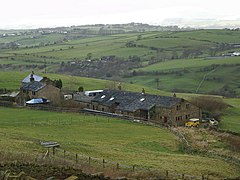 Monk Hall farm | |
 Briercliffe with Extwistle Shown within Burnley Borough Show map of the Borough of Burnley  Briercliffe with Extwistle Briercliffe with Extwistle shown within Lancashire Show map of Lancashire | |
| Area | 6.53 sq mi (16.9 km2) [1] |
| Population | 4,031 (2011) [1] |
| • Density | 617/sq mi (238/km2) |
| OS grid reference | SD8749034897 |
| Civil parish |
|
| District |
|
| Shire county |
|
| Region |
|
| Country | England |
| Sovereign state | United Kingdom |
| Post town | BURNLEY |
| Postcode district | BB10 |
| Dialling code | 01282 |
| Police | Lancashire |
| Fire | Lancashire |
| Ambulance | North West |
| EU Parliament | North West England |
| UK Parliament |
|
Briercliffe (or Briercliffe-with-Extwistle) is a civil parish in the borough of Burnley, in Lancashire, England. It is situated 3 miles (4.8 km) north of Burnley.[2] The parish contains suburbs of Burnley (including Harle Syke and Haggate), and the rural area north east of the town. Hamlets in the parish include Cockden, Lane Bottom and in the Extwistle area, the tiny hamlet of Roggerham.
The parish adjoins the Burnley parish of Worsthorne-with-Hurstwood and the unparished area of Burnley, the Pendle parishes of Brierfield, Nelson and Trawden Forest and West Yorkshire. According to the United Kingdom Census 2011, the parish has a population of 4,031,[1] an increase from 3,187 in the 2001 census.[3]
Briercliffe-with-Extwistle was once a township in the ancient parish of Whalley, becoming a civil parish in 1866.[4] In 1894, the parish was dissolved, part moving into the county borough of Burnley, with the rest becoming a new parish called Briercliffe, forming part of the Burnley Rural District.[5]
Contents
1 Extwistle Hall
2 People
2.1 Tattersall Wilkinson
3 Media gallery
4 See also
5 References
6 External links
Extwistle Hall
Extwistle Hall stands high on Extwistle Moor between Haggate (east of Brierfield) and the village of Worsthorne. The Hall, built of coursed sandstone on three sides of a courtyard, is now a ruin.[6] It was built in the 16th century in the Tudor style by the Parker family who were prominent in local affairs.
Robert Parker had bought the land, which had previously belonged to Kirkstall Abbey, in 1537 after the Dissolution of the Monasteries. The Parker family occupied it for some two hundred years before moving to Cuerden Hall around 1718.[7] John Parker was High Sheriff of Lancashire for 1653 and Robert Parker for 1710. The house was remodelled in the late 18th century.
The listed Grade II*[8] building, owned by an Isle of Man based property company, has been unoccupied for more than twenty years and is listed in English Heritage's Heritage at Risk Register.[9] In January 2012, £2million plans were revealed to save and restore the hall to its former glory, then afterwards to be sold off.[10]
People
Tattersall Wilkinson
Tattersall Wilkinson was a local antiquarian most usually known as 'The Sage Of Roggerham'.[11] Tattersall was well known in Burnley during the late 1800s. He was the first person to uncover the flint daggers and stone circles of nearby Worsthorne, and other antiquities such as burial urns. He also wrote many articles for the Burnley Express and a book of his own (with J.F Tattersall) named 'Memories Of Hurstwood'.
Media gallery
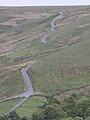
Halifax Road passing through the Thursden Valley

Extwistle Hall

World War II Pillbox

Lane Bottom

Roggerham Gate Inn
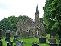
St James' Church Harle Syke


See also
- Listed buildings in Briercliffe
References
^ abc UK Census (2011). "Local Area Report – Briercliffe Parish (1170214981)". Nomis. Office for National Statistics. Retrieved 8 February 2018..mw-parser-output cite.citationfont-style:inherit.mw-parser-output qquotes:"""""""'""'".mw-parser-output code.cs1-codecolor:inherit;background:inherit;border:inherit;padding:inherit.mw-parser-output .cs1-lock-free abackground:url("//upload.wikimedia.org/wikipedia/commons/thumb/6/65/Lock-green.svg/9px-Lock-green.svg.png")no-repeat;background-position:right .1em center.mw-parser-output .cs1-lock-limited a,.mw-parser-output .cs1-lock-registration abackground:url("//upload.wikimedia.org/wikipedia/commons/thumb/d/d6/Lock-gray-alt-2.svg/9px-Lock-gray-alt-2.svg.png")no-repeat;background-position:right .1em center.mw-parser-output .cs1-lock-subscription abackground:url("//upload.wikimedia.org/wikipedia/commons/thumb/a/aa/Lock-red-alt-2.svg/9px-Lock-red-alt-2.svg.png")no-repeat;background-position:right .1em center.mw-parser-output .cs1-subscription,.mw-parser-output .cs1-registrationcolor:#555.mw-parser-output .cs1-subscription span,.mw-parser-output .cs1-registration spanborder-bottom:1px dotted;cursor:help.mw-parser-output .cs1-hidden-errordisplay:none;font-size:100%.mw-parser-output .cs1-visible-errorfont-size:100%.mw-parser-output .cs1-subscription,.mw-parser-output .cs1-registration,.mw-parser-output .cs1-formatfont-size:95%.mw-parser-output .cs1-kern-left,.mw-parser-output .cs1-kern-wl-leftpadding-left:0.2em.mw-parser-output .cs1-kern-right,.mw-parser-output .cs1-kern-wl-rightpadding-right:0.2em
^ "Parish Council Details: Briercliffe-with-Extwistle Parish Council". Lancashire Parish Portal. Lancashire County Council. Archived from the original on 27 May 2008. Retrieved 31 October 2008.
^ Office for National Statistics : Census 2001 : Parish Headcounts : Burnley Retrieved 4 February 2010
^ "Briercliffe-with-Extwistle Tn/CP through time". visionofbritain.org.uk. GB Historical GIS / University of Portsmouth. Retrieved 25 July 2015.
^ "Briercliffe CP through time". visionofbritain.org.uk. GB Historical GIS / University of Portsmouth. Retrieved 25 July 2015.
^ Historic England. "EXTWISTLE HALL (45313)". PastScape. Retrieved 18 January 2013.
^ "history of Extwistle Hall". Retrieved 18 January 2013.
^ British Listed Buildings, accessed 29 March 2012
^ "Extwistle Hall and attached garden wall", Heritage at Risk Register, English Heritage, archived from the original on 14 July 2012, retrieved 29 April 2012
^ Tyrone Marshall (11 January 2012). "£2.4million housing development plans for Briercliffe". Lancashire Telegraph. Retrieved 29 April 2012.
^ "Insight into history from 19th-century village 'sage'". Lancashire Telegraph. Retrieved 29 April 2012.
External links
![]() Media related to Briercliffe at Wikimedia Commons
Media related to Briercliffe at Wikimedia Commons
- Map of Briercliffe (272) and Extwistle (273) parish boundaries
- Briercliffe-with-Extwistle Township - British History Online
- The Briercliffe Society
Geography of the Borough of Burnley | |||||||
|---|---|---|---|---|---|---|---|
| Towns |
|  | |||||
| Villages & suburbs |
| ||||||
| Parishes |
| ||||||
| Topography |
| ||||||


