Northern Kentucky
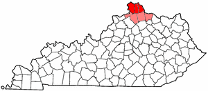
Northern Kentucky is the name often given to the northernmost (most typically the three northernmost) counties in Kentucky (Boone, Kenton, Campbell, shown in red on the map). Gallatin, Grant, Pendleton, and Bracken counties (highlighted in pink on the map) are often grouped with the aforementioned and are officially part of the Cincinnati metropolitan area, and are sometimes included in definitions of "Northern Kentucky." Historically, Trimble, Mason, and Lewis counties have also been included in "Northern Kentucky."
The three northernmost counties of Kentucky each has at least one major center of population: Florence in Boone County; Covington, Erlanger, and Independence in Kenton County; and Newport, Fort Thomas, and Alexandria in Campbell County. Immediately on the northern side of the Ohio River from Covington and Newport is Cincinnati, Ohio. However, the entire core region is relatively densely populated, with these cities surrounded by many smaller towns which have little other than a city limit sign between them. The periphery of Boone, Kenton, and Campbell counties, namely the western half of Boone County, and southernmost parts of all three of the core counties, are still primarily rural in nature. The area, primarily the three northernmost counties, has a high amount of German heritage and moderate Irish heritage, being across the river from Cincinnati. The four outer counties are still primarily rural. Combined with the southeast corner of Indiana, and Southwestern Ohio, all seven counties are a part of the Greater Cincinnati area, which has a population over two million.
The area was served by ferry service across the Ohio River until the completion of the John A. Roebling Suspension Bridge (prototype of the famous Brooklyn Bridge) in 1866, whereupon land values in the areas near the river quadrupled overnight.
Beginning in the 1970s, many factors combined to create major growth. The proximity to Cincinnati, the completion of I-75, the nexus of rail service and river traffic, creation of several industrial parks, and the growth of Cincinnati/Northern Kentucky International Airport (located near Hebron in northeastern Boone County near the Kenton County line) drew many industries into the area. Its geographically central location (within 800 miles (1,300 km) of 80% of the US population) makes it ideal for distribution centers, and those shipping all over the country.
In addition to location, the Northern Kentucky area hosts several organizations which strive to enhance the quality of life and the local economy. These organizations include: The Northern Kentucky Chamber of Commerce (NKY Chamber), the Northern Kentucky Tri-County Economic Development Corporation (NKY Tri-ED), Vision 2015, Southbank Partners, the Catalytic Fund, the Northern Kentucky One Stop, and the Kentucky Cabinet for Economic Development (KCED). The primary airport (CVG) serving Cincinnati is located in Northern Kentucky.[1]
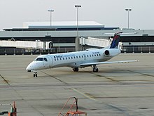
Plane at CVG-Cincinnati and Northern Kentucky's International Airport
Climate
Northern Kentucky is located within a climatic transition zone and is at the extreme northern limit of the humid subtropical climate. Evidence of both humid subtropical climate and humid continental climate can be found here, particularly noticeable by the presence of plants indicative of each climatic region; for example, the Southern magnolia, and Crape-myrtle, from the subtropics and the Blue spruce, Maple, and Eastern Hemlock from cooler regions are successful landscape plants in and around Northern Kentucky. Some significant moderating variables for the overall climate of Northern Kentucky include: the Ohio River, the region's relatively large hills and valleys, and an urban heat influence due to the proximity of the Cincinnati/Northern Kentucky metropolitan area. The common wall lizard, introduced from Italy in the 1950s, is an example of fauna in the area that lends a subtropical ambiance to areas near the urban core of Cincinnati. Northern Kentucky is considered to be within the periphery of both the Midwest and the Upland South.
| Geographic Area | July 1, 2008 | July 1, 2005 | Census 2000 | 1990 Census | 1980 Census | 1970 Census | 1960 Census | 1950 Census |
|---|---|---|---|---|---|---|---|---|
TOTAL | 417,079 | 403,336 | 362,741 | 315,390 | 302,583 | 282,257 | 261,191 | 225,353 |
Boone County, Kentucky | 115,231 | 106,272 | 85,991 | 57,589 | 45,842 | 32,812 | 21,940¹ | 13,015¹ |
Bracken County, Kentucky | 8,569 | 8,279¹ | 7,766¹ | 7,738¹ | 7,227¹ | 7,422¹ | 8,424¹ | |
Campbell County, Kentucky | 87,038 | 87,251 | 88,616 | 83,866 | 83,317 | 88,501 | 86,803 | 76,196 |
Gallatin County, Kentucky | 8,071 | 8,134 | 7,870 | 5,393¹ | 4,842¹ | 4,134¹ | 3,867¹ | 3,969¹ |
Grant County, Kentucky | 25,549 | 24,610 | 22,384 | 15,737¹ | 13,308¹ | 9,999¹ | 9,489¹ | 9,809¹ |
Kenton County, Kentucky | 157,629 | 153,665 | 151,464 | 142,031 | 137,058 | 129,440 | 120,700 | 104,254 |
Pendleton County, Kentucky | 14,992 | 15,125 | 14,390 | 12,036¹ | 10,989¹ | 9,949¹ | 9,968¹ | 9,610¹ |
References
^ "Cincinnati/Northern Kentucky International Airport". Retrieved 11 April 2014..mw-parser-output cite.citationfont-style:inherit.mw-parser-output .citation qquotes:"""""""'""'".mw-parser-output .citation .cs1-lock-free abackground:url("//upload.wikimedia.org/wikipedia/commons/thumb/6/65/Lock-green.svg/9px-Lock-green.svg.png")no-repeat;background-position:right .1em center.mw-parser-output .citation .cs1-lock-limited a,.mw-parser-output .citation .cs1-lock-registration abackground:url("//upload.wikimedia.org/wikipedia/commons/thumb/d/d6/Lock-gray-alt-2.svg/9px-Lock-gray-alt-2.svg.png")no-repeat;background-position:right .1em center.mw-parser-output .citation .cs1-lock-subscription abackground:url("//upload.wikimedia.org/wikipedia/commons/thumb/a/aa/Lock-red-alt-2.svg/9px-Lock-red-alt-2.svg.png")no-repeat;background-position:right .1em center.mw-parser-output .cs1-subscription,.mw-parser-output .cs1-registrationcolor:#555.mw-parser-output .cs1-subscription span,.mw-parser-output .cs1-registration spanborder-bottom:1px dotted;cursor:help.mw-parser-output .cs1-ws-icon abackground:url("//upload.wikimedia.org/wikipedia/commons/thumb/4/4c/Wikisource-logo.svg/12px-Wikisource-logo.svg.png")no-repeat;background-position:right .1em center.mw-parser-output code.cs1-codecolor:inherit;background:inherit;border:inherit;padding:inherit.mw-parser-output .cs1-hidden-errordisplay:none;font-size:100%.mw-parser-output .cs1-visible-errorfont-size:100%.mw-parser-output .cs1-maintdisplay:none;color:#33aa33;margin-left:0.3em.mw-parser-output .cs1-subscription,.mw-parser-output .cs1-registration,.mw-parser-output .cs1-formatfont-size:95%.mw-parser-output .cs1-kern-left,.mw-parser-output .cs1-kern-wl-leftpadding-left:0.2em.mw-parser-output .cs1-kern-right,.mw-parser-output .cs1-kern-wl-rightpadding-right:0.2em
External links
- Northern Kentucky Convention and Visitors Bureau
Frankfort (capital) | ||
| Topics |
|  Seal of Kentucky |
| Society |
| |
| Regions |
| |
| 25 largest cities |
| |
| Metropolitan areas |
| |
| Counties |
| |