Monte Bondone
| Monte Bondone | |
|---|---|
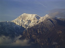 Monte Bondone seen from Povo. | |
| Highest point | |
| Elevation | 2,180 m (7,150 ft) |
| Prominence | 1,685 m (5,528 ft) [1] |
| Listing | Ultra |
| Coordinates | 45°59′17″N 11°1′51″E / 45.98806°N 11.03083°E / 45.98806; 11.03083Coordinates: 45°59′17″N 11°1′51″E / 45.98806°N 11.03083°E / 45.98806; 11.03083 |
| Geography | |
 Monte Bondone Location | |
| Location | Trentino, Italy |
| Parent range | Garda Mountains |

Viote Landscape
Monte Bondone is a mountain of Trentino, northern Italy, located west of the provincial capital of Trento. It has an elevation of 2,180 metres (7,152 ft). It is highest mountain of the Garda Prealps and with a prominence of 1,685 metres (5,528 ft) it qualifies as an Ultra. It lies between the Etschtal valley in the east and the Sarca valley in the west. Due to its location high above the city, it is often called the mountain of Trento.[2]
References
^ "Monte Bondone". Peakbagger.com. Retrieved 23 February 2015..mw-parser-output cite.citationfont-style:inherit.mw-parser-output .citation qquotes:"""""""'""'".mw-parser-output .citation .cs1-lock-free abackground:url("//upload.wikimedia.org/wikipedia/commons/thumb/6/65/Lock-green.svg/9px-Lock-green.svg.png")no-repeat;background-position:right .1em center.mw-parser-output .citation .cs1-lock-limited a,.mw-parser-output .citation .cs1-lock-registration abackground:url("//upload.wikimedia.org/wikipedia/commons/thumb/d/d6/Lock-gray-alt-2.svg/9px-Lock-gray-alt-2.svg.png")no-repeat;background-position:right .1em center.mw-parser-output .citation .cs1-lock-subscription abackground:url("//upload.wikimedia.org/wikipedia/commons/thumb/a/aa/Lock-red-alt-2.svg/9px-Lock-red-alt-2.svg.png")no-repeat;background-position:right .1em center.mw-parser-output .cs1-subscription,.mw-parser-output .cs1-registrationcolor:#555.mw-parser-output .cs1-subscription span,.mw-parser-output .cs1-registration spanborder-bottom:1px dotted;cursor:help.mw-parser-output .cs1-ws-icon abackground:url("//upload.wikimedia.org/wikipedia/commons/thumb/4/4c/Wikisource-logo.svg/12px-Wikisource-logo.svg.png")no-repeat;background-position:right .1em center.mw-parser-output code.cs1-codecolor:inherit;background:inherit;border:inherit;padding:inherit.mw-parser-output .cs1-hidden-errordisplay:none;font-size:100%.mw-parser-output .cs1-visible-errorfont-size:100%.mw-parser-output .cs1-maintdisplay:none;color:#33aa33;margin-left:0.3em.mw-parser-output .cs1-subscription,.mw-parser-output .cs1-registration,.mw-parser-output .cs1-formatfont-size:95%.mw-parser-output .cs1-kern-left,.mw-parser-output .cs1-kern-wl-leftpadding-left:0.2em.mw-parser-output .cs1-kern-right,.mw-parser-output .cs1-kern-wl-rightpadding-right:0.2em
^ "Monte Bondone". summitpost.org. Retrieved 23 February 2015.
External links
Monte Bondone tourist promotional agency website (in Italian) (in English) (in German)

Viote Landscape

Dos D'Abramo and Monte Cornetto seen from Cima Verde
This Trentino-Alto Adige/Südtirol location article is a stub. You can help Wikipedia by expanding it. |


