Shadia, Punjab
Shadia | |
|---|---|
Town and union council | |
| Country | Pakistan |
| Region | Punjab |
| District | Mianwali District |
| Time zone | UTC+5 (PST) |
Shadia is a town and union council of the Mianwali District in the Punjab province of Pakistan.[1] It is part of the Mianwali Tehsil subdivision and is located at 32°22'46N 71°45'39E and has an altitude of 198 metres (652 ft)[2] and a population of approximately 17,783.
Shadia may have been named after the word shadi which means marriage in Urdu/Punjabi. In the 18th century Shadia was famous for frequent marriage processions to adjacent villages and places such as Bandial, Okhli Mohla, or Jabbi Dhokri. Shadia was a hub for matrimonial ceremonies, as well as a resting place for caravans.
According to another tradition the village is called Shadia because there used to be a lamp or deeya on the grave of a syed, commonly known as the Shah. The name shah da deeya was gradually corrupted to Shadia.
The union council of Shadia consists of Shadia itself as well as other surrounding towns and villages: Dhakuwa Wala, Pakka Sandanwala, Muhammad Shah, Chak No.1, Chak No.2, Chak No.3, Chak No.4, Chak Qudrat Abad, Chandni, Maira, Taala, and Dera Jaat.
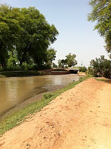
Much of the land in Shadia and its environs is irrigated by the Chashma Mohajir branch canal, though some of Shadia's soil is desert and is irrigated by rainwater only. Shadia has fertile lands which yield seasonal crops, such as kinos (mandarins) and oranges of all types, wheat, sugar cane, cotton, rice, channa and guara. Shadia is particularly famous for its mandarin orchards, which are the second largest in Pakistan after Sargodha.
Another prominent site in Shadia is one of Asia's oldest graveyards, Wanjhara. It is believed Wanjhara was built on a ruined city which was devastated in an earthquake centuries ago, and several times during the excavation of graves people have found old pottery and remnants of antique household items which may have been used in the Hindu Era before the invasion of India by Muslim conquerors.
The inhabitants of this village are mostly zamindars consisting of the Janjua clan
References
^ Tehsils & Unions in the District of Mianwali - Government of Pakistan Archived 2008-06-11 at the Wayback Machine.
^ Location of Shadia - Falling Rain Genomics
Coordinates: 32°22′46″N 71°45′39″E / 32.37944°N 71.76083°E / 32.37944; 71.76083


