Serra d'Esparreguera
| Serra d'Esparreguera | |
|---|---|
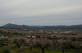 Eastern end of the Serra d'Esparreguera, near Albocàsser; the Penyagolosa can be discerned in the distance | |
| Highest point | |
| Elevation | 1,087 m (3,566 ft) |
| Listing | List of mountains in the Valencian Community |
| Coordinates | 40°18′31″N 0°5′21″W / 40.30861°N 0.08917°W / 40.30861; -0.08917Coordinates: 40°18′31″N 0°5′21″W / 40.30861°N 0.08917°W / 40.30861; -0.08917 |
| Geography | |
 Serra d'Esparreguera Spain | |
| Location | Alt Maestrat, Valencian Community |
| Parent range | Iberian System, Eastern end |
| Geology | |
| Mountain type | Karstic |
| Climbing | |
| Easiest route | From Culla or from La Torre d'En Besora |
Serra de d'Esparreguera or Serra Esparreguera[1] (Spanish: Sierra de Esparraguera,[2] although the spellings Sierra de Espaneguera or Sierra Espaneguera are common in many maps[3]) is an over 17 km (11 mi) long mountain range in the Alt Maestrat comarca, Valencian Community, Spain.
Contents
1 Geography
2 See also
3 References
4 External links
Geography
This mountain chain rises abruptly from a plain and looks quite impressive from certain angles. It extends in a roughly SW-NE direction between Atzeneta del Maestrat and Albocàsser. Its highest point is 1087 m high Esparreguera; another important summit is Morral Blanc (1060 m). These mountains are frequently covered in snow in the winter.
See also
- Culla
- Mountains of the Valencian Community
References
^ Vicenç M. Rosselló i Verger, Toponímia, geografia i cartografia
^ Sierra de Esparraguera ca. 829 m
^ Mendikat Espaneguera
External links
- El País Valencià poble a poble; comarca a comarca - Alt Maestrat
- La Torre d'En Besora tourism