| Mason-Dixon Trail |
|---|
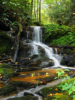 Upper Mill Creek Falls as seen from the Mason-Dixon Trail in York County
|
| Length |
193 mi (311 km) |
|---|
| Location |
Delaware / Maryland / Pennsylvania, USA
|
|---|
| Designation |
National Recreation Trail |
|---|
| Trailheads |
South: Appalachian Trail at Whiskey Springs, Pennsylvania
North: Brandywine Creek at Chadds Ford, Pennsylvania
|
|---|
| Use |
Hiking |
|---|
The Mason-Dixon Trail is a 195.9-mile (315.3 km), blue-blazed footpath that connects the Appalachian Trail with the Brandywine Trail, passing through Gifford Pinchot State Park and White Clay Creek Preserve in Pennsylvania and White Clay Creek State Park in Delaware.[1] About 30 per cent of the "trail" is a route marked along public roads; the remainder is actual trail.[2]
The trail starts near Mount Holly Springs at Whiskey Springs on the Appalachian Trail, in Cumberland County, Pennsylvania. It then heads east towards the Susquehanna River, passing through Gifford Pinchot State Park. The trail then follows the west bank of the Susquehanna south, first to Wrightsville, Pennsylvania, and then to Havre de Grace, Maryland. In the 65-mile (105 km) section between Wrightsville and Havre de Grace, it passes Long Level, Holtwood Dam, Susquehanna and Tidewater Canal Lock 12, Peach Bottom, and Conowingo Dam. The trail then crosses the Susquehanna River, passes through Elk Neck State Park, and crosses the border between Maryland and Delaware. After heading northeast through Newark, Delaware, the Mason-Dixon Trail ends at Chadds Ford on the banks of Brandywine Creek near the Delaware border.

A rough overview of the 200-mile-long Mason-Dixon Trail
"Mason Dixon Trail- York County" This 30 mile section follows across the lower Susquehanna River in Pennsylvania.
References
^ Backpacking Pennsylvania: 37 Great Hikes, Mitchell, Stackpole Books, 2004, .mw-parser-output cite.citationfont-style:inherit.mw-parser-output qquotes:"""""""'""'".mw-parser-output code.cs1-codecolor:inherit;background:inherit;border:inherit;padding:inherit.mw-parser-output .cs1-lock-free abackground:url("//upload.wikimedia.org/wikipedia/commons/thumb/6/65/Lock-green.svg/9px-Lock-green.svg.png")no-repeat;background-position:right .1em center.mw-parser-output .cs1-lock-limited a,.mw-parser-output .cs1-lock-registration abackground:url("//upload.wikimedia.org/wikipedia/commons/thumb/d/d6/Lock-gray-alt-2.svg/9px-Lock-gray-alt-2.svg.png")no-repeat;background-position:right .1em center.mw-parser-output .cs1-lock-subscription abackground:url("//upload.wikimedia.org/wikipedia/commons/thumb/a/aa/Lock-red-alt-2.svg/9px-Lock-red-alt-2.svg.png")no-repeat;background-position:right .1em center.mw-parser-output .cs1-subscription,.mw-parser-output .cs1-registrationcolor:#555.mw-parser-output .cs1-subscription span,.mw-parser-output .cs1-registration spanborder-bottom:1px dotted;cursor:help.mw-parser-output .cs1-hidden-errordisplay:none;font-size:100%.mw-parser-output .cs1-visible-errorfont-size:100%.mw-parser-output .cs1-subscription,.mw-parser-output .cs1-registration,.mw-parser-output .cs1-formatfont-size:95%.mw-parser-output .cs1-kern-left,.mw-parser-output .cs1-kern-wl-leftpadding-left:0.2em.mw-parser-output .cs1-kern-right,.mw-parser-output .cs1-kern-wl-rightpadding-right:0.2em
ISBN 0-8117-3180-4
^ Blue Ridge Outdoors
External links
Mason-Dixon Trail System - official home page
Mason-Dixon Trail on Facebook - official Facebook Page
Hiking trails in Pennsylvania
|
|---|
- Allegheny Front
- Appalachian
- Baker
- Black Forest
- Brandywine
- Bucktail Path
- Chester Valley
- Chuck Keiper
- Conestoga
- Cresheim
- Cross County
- Darlington
- Donut Hole
- Evansburg
- Forbes Road
- GAP
- GET
- Glacier Ridge
- Golden Eagle
- Horse-Shoe
- John P. Saylor
- Laurel Highlands
- Liberty Bell
- Lost Turkey
- Lower
- Loyalsock
- Mason-Dixon
- Mid State
- Mill Creek
- Montour
- North Country
- Old Loggers Path
- Panhandle
- Pennypack
- Perkiomen
- Pinchot
- Pine Creek
- Potomac Heritage
- Power Line
- Quebec Run
- Quehanna
- Rachel Carson
- Rock Run
- Schuylkill East
- Schuylkill River
- Standing Stone
- Struble
- Susquehannock
- Tanbark
- Terrace Mountain
- Thunder Swamp
- Tuscarora
- US 202 Parkway
- Valley Forge
- Warrior
- West Rim
- Wissahickon
- Youghiogheny River
|
|
Hiking trails in Maryland
|
|---|
- Allegheny Highlands
- American Discovery
- Anacostia Tributaries
- Appalachian
- B&A
- Billy Goat
- Borden Tunnel
- BWI
- Capital Crescent
- Catoctin
- C&O Canal
- College Park Trolley
- Cross Island
- Dalecarlia Tunnel
- East Coast Greenway
- Eastern Continental
- GAP
- Great Eastern
- Grist Mill
- Gwynns Falls
- Jones Falls
- Ma and Pa
- Mason-Dixon
- Metropolitan Branch
- North Bethesda
- Patuxent Branch
- Potomac Heritage
- Rachel Carson
- Savage Mill
- Short Line
- Sligo Creek
- Torrey C. Brown (Northern Central)
- Trolley Line #9
- Tuscarora
- WB&A
- WMRT
|
|
Protected areas of Pennsylvania
|
|---|
| Federal |
NPS National Historical Parks
& National Historic Sites |
- Allegheny Portage Railroad NHS
- Edgar Allan Poe NHS
- Eisenhower NHS
- First State NHP
- Friendship Hill NHS
- Gloria Dei (Old Swedes') Church NHS
- Hopewell Furnace NHS
- Independence NHP
- Steamtown NHS
- Valley Forge NHP
|
|---|
| National Memorials |
- Benjamin Franklin
- Flight 93
- Johnstown Flood
- Thaddeus Kosciuszko
|
|---|
National Battlefields and
National Military Parks
|
- Fort Necessity NB
- Gettysburg NMP
|
|---|
| National Trails |
|
|---|
| Other protected areas |
- Allegheny National Recreation Area
- Blue Marsh National Recreation Area
- Delaware and Lehigh National Heritage Corridor
- Delaware Water Gap National Recreation Area
- Lackawanna Heritage Valley National and State Heritage Area
- Middle Delaware National Scenic River
- Upper Delaware Scenic and Recreational River
|
|---|
| National Forests |
|
|---|
| USFS National Historic Sites |
|
|---|
| National Wildlife Refuges |
- Cherry Valley
- Erie
- John Heinz
- Ohio River Islands
|
|---|
|
|---|
| State |
| State Parks |
|
|---|
| State Forests |
- Bald Eagle
- Buchanan
- Clear Creek
- Cornplanter
- Delaware
- Elk
- Forbes
- Gallitzin
- Loyalsock
- Michaux
- Moshannon
- Pinchot
- Rothrock
- Sproul
- Susquehannock
- Tiadaghton
- Tioga
- Tuscarora
- Weiser
- William Penn
|
|---|
| Scenic Rivers |
- Bear Run
- French Creek
- Lehigh River
- LeTort Spring Run
- Lick Run
- Lower Brandywine
- Octoraro Creek
- Pine Creek
- Schuylkill River
- Stony Creek
- Tucquan Creek
- Tulpehocken Creek
- Yellow Breeches Creek
|
|---|
| State Game Lands |
|
|---|
| Wild areas |
- Algerine
- Asaph
- Burns Run
- Clear Shade
- Hammersley
- Kettle Creek
- Russell P. Letterman
- Martin Hill
- McIntyre
- Quebec Run
- Quehanna
- Thickhead Mountain
- Trough Creek
- Tuscarora
- White Mountain
- Wolf Run
|
|---|
|
|---|
| Other |
|
|---|
 Category Category
- Pennsylvania Department of Conservation and Natural Resources
- Philadelphia
 Commons Commons
|
Protected areas of Maryland
|
|---|
| Federal |
| National battlefields |
|
|---|
| National historical parks |
- Chesapeake and Ohio Canal
- Harriet Tubman Underground Railroad
|
|---|
| National historic sites |
- Clara Barton
- Hampton
- Thomas Stone
|
|---|
| National monuments |
- Fort McHenry National Monument and Historic Shrine
|
|---|
| National seashores |
|
|---|
National Park Service
parks |
- Catoctin Mountain Park
- Fort Foote Park
- Fort Washington Park
- Glen Echo Park
- Greenbelt Park
- Harmony Hall
- Oxon Cove Park and Oxon Hill Farm
- Piscataway Park
|
|---|
| National wildlife refuges |
- Blackwater
- Eastern Neck
- Martin
- Patuxent Research Refuge
- Susquehanna River
|
|---|
National historic
and scenic trails |
- Appalachian Trail
- Captain John Smith Chesapeake National Historic Trail
- Potomac Heritage National Scenic Trail
- Star-Spangled Banner National Historic Trail
|
|---|
| Other protected areas |
- Chesapeake Bay Gateways Network
- Chesapeake Bay National Estuarine Research Reserve
|
|---|
|
|---|
| State |
|
|---|
County and
municipal |
| Parks and sanctuaries |
- Acorn
- Allen Pond
- Belmont
- Blandair
- Benjamin Banneker
- Carroll
- Centennial
- Clifton
- Constitution
- Cromwell Valley
- Cylburn Arboretum
- David Force
- Dinosaur
- Druid Hill
- Fairgrounds
- Falls Road-Hadley
- Federal Hill
- Flag Ponds
- Fort Smallwood
- Foxhill
- Gene Mason
- Generals
- Gwynns Falls Leakin
- Gwynn Oak
- Hagerstown City
- Herring Run
- Jefferson Patterson
- Jonas Green
- Jug Bay Wetlands
- Kinder Farm
- Lake Artemesia
- Lake Elkhorn
- Lakefront
- Lakelands
- Lake Roland
- Liberty Reservoir
- Loch Raven
- Middle Patuxent
- Oregon Ridge
- Patterson
- Pen Mar
- Prettyboy Reservoir
- Quiet Waters
- Riverside
- Rockburn Branch
- Thomas A. Dixon Jr. Aircraft Observation Area
- Sligo Creek
- Symphony Woods
- Troy
- Wilde Lake
- Wheaton
- Wyman
|
|---|
|
|---|
Non-
governmental |
| Parks and sanctuaries |
- Battle Creek Cypress Swamp Sanctuary
- Conservation and Environmental Research Areas of UMBC
- Merkle Wildlife Sanctuary
- Mount Pleasant Farm Center
- Sherwood Gardens
- Somers Cove Marina
- Sugarloaf Mountain
- University of Maryland Arboretum & Botanical Garden
- Western Maryland Rail Trail
- Youghiogheny Scenic & Wild River
|
|---|
| Nature centers |
- List of nature centers in Maryland
|
|---|
|
|---|
Maryland Department of Natural Resources (web): Maryland Forest Service and Maryland Park Service (web)
|
Coordinates: 39°32′20″N 75°40′02″W / 39.53899°N 75.66730°W / 39.53899; -75.66730